Walkers, hikers or ramblers?

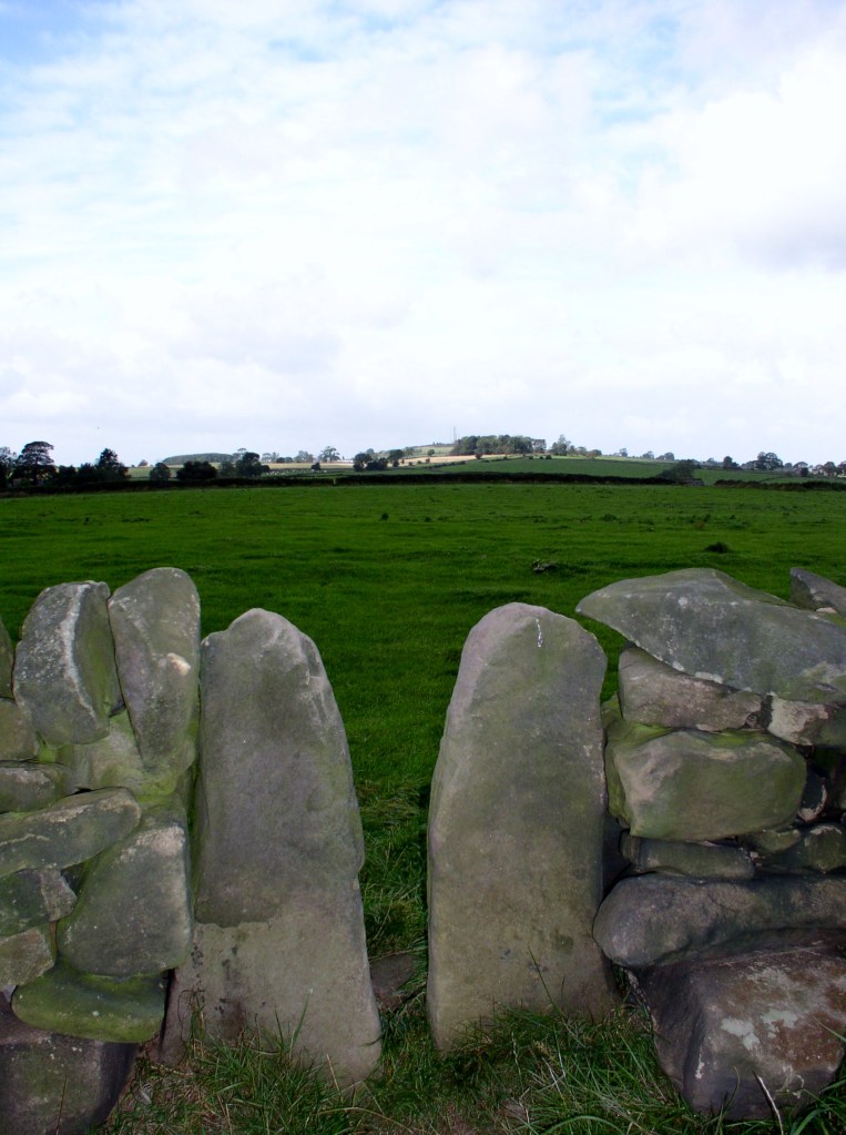
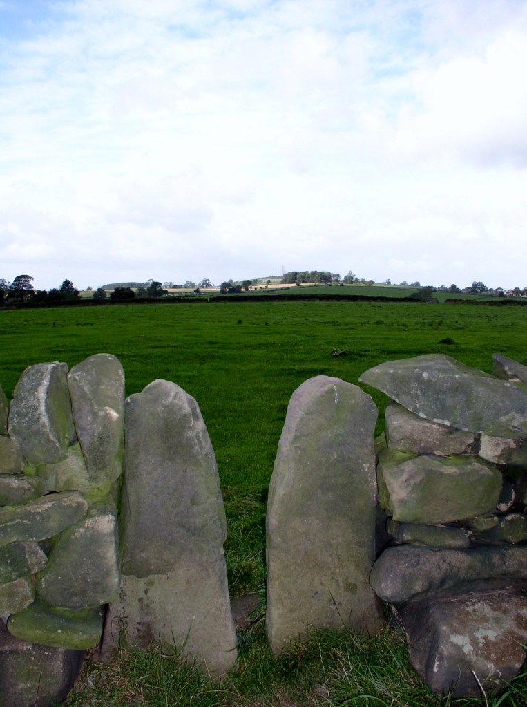
Squeeze style on path to Alport Height

Many of our field paths were created by people walking to work, possibly in mines or mills. With the enclosure of moors and commons in the late eighteenth or early nineteenth centuries and the building of drystone walls to delineate the new fields, these routes became fossilised, often marked by a series of squeeze stiles, as on the path above. Today the mills and mines have gone, yet the paths are kept open by walkers – a leisure activity that would probably have surprised the mill hands of Arkwright’s day.

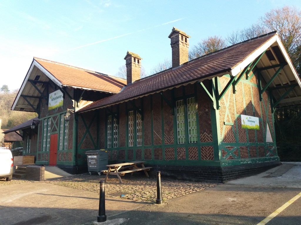
Matlock Bath’s Swiss-style station

Walking for pleasure became popular from the mid-nineteenth century, as some workers in the industrial cities of Sheffield and Manchester gained a half-day holiday on Saturday and were able to take advantage of the new railway lines to escape from the smoky cities into the hills of Derbyshire, Yorkshire and Lancashire. At first the focus was on the Dark Peak moors, especially Kinderscout, which became a regular scene of conflict between walkers and the gamekeepers employed by the Duke of Devonshire, who owned much of the moors.

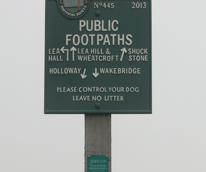
PNFS signpost near Alderwasley

The Manchester Association for the Preservation of Ancient Public Footpaths was founded as early as 1826, and Manchester remained a centre for the defence of workers’ interests, notably establishing the first public library (1852) and the first cooperative society (Rochdale, 1844). In 1894 the Peak District and Northern Counties Footpath Preservation Association (thankfully abbreviated now to Peak & Northern) was formed, and is still doing excellent work defending walkers’ rights and interests, notably through over 500 steel signs like the one above.

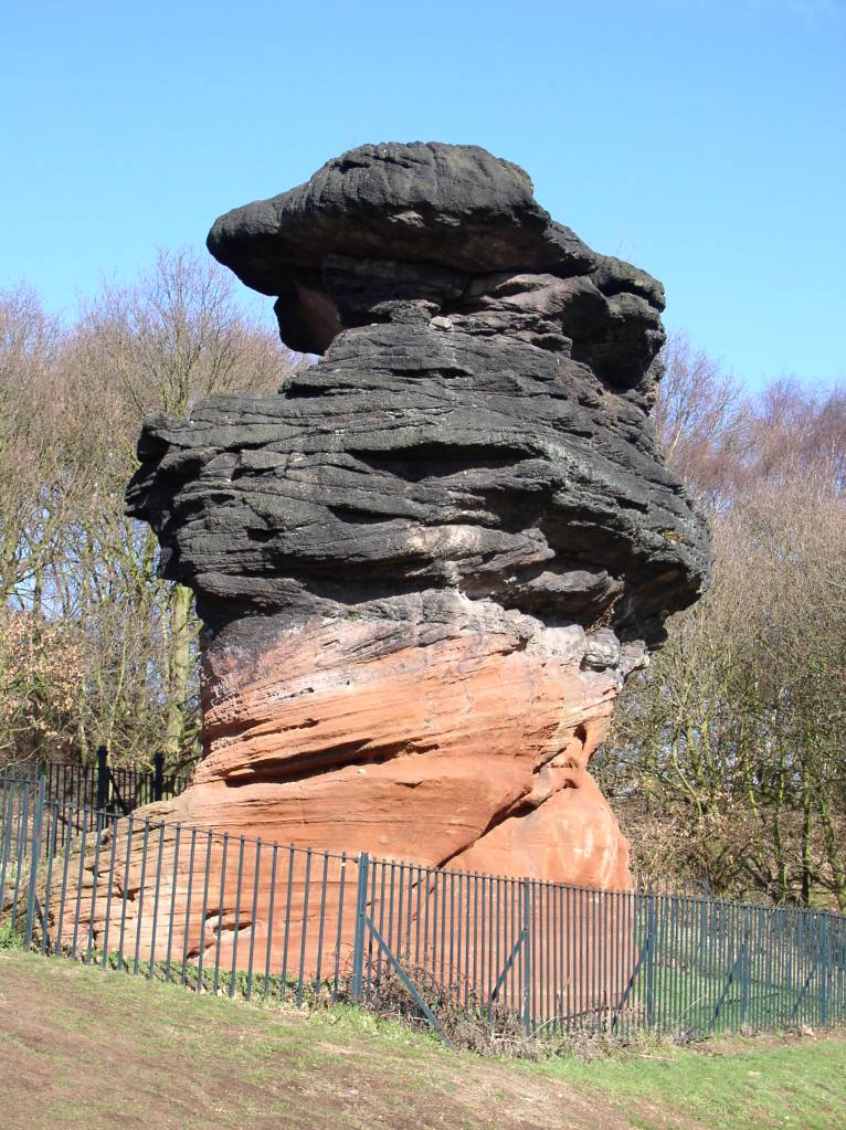
The Hemlock Stone today

The inter-war Kinderscout mass trespass has been widely publicised, but it was far from typical of the experience of many walkers in the Derbyshire hills. In general farmers and landowners have respected public rights of way and co-existed succesfully with ramblers. Perhaps a more typical walk is described by DH Lawrence in his Bildungsroman novel Sons and Lovers. Here, a party of friends and family, mostly connected with the Eastwood Congregationalists, set out to walk from Eastwood to the Hemlock Stone in Bramcote Hills one Bank Holiday. The walk actually took place at Easter 1905, and is an example of the way young people at that time, with little spare cash but plenty of energy, enjoyed their precious free time. The connection exemplified there between nonconformity, radical thought and hiking is interesting, and worth exploring further.

Milestoned?

Milestone from Bakewell to Ashbourne turnpike, near Winster

As might be expected, the Romans were the first to use milestones in Britain. Theirs were usually stone cylinders, and a fragment of one is in Buxton Museum. Clearly, they had two useful functions: not only did they tell travellers how far they had to go, but at the same time they provided reassurance that they were on the right road. Unsurprisingly, no Roman milestones survive in situ, and they were not seen here again until the eighteenth century.

Milestone near Matlock Bath

The turnpike trusts seem to have re-introduced milestones on their routes, with each trust using a slightly different style, as seen in the two examples above. Spelling of place names is also non-standardized. Many of these survive, and provide a useful indicator of the routes of different trusts. For instance, on the Alfreton to Ashbourne route, between Crich and Carsington almost all the stones are still in place, although sometimes they are hidden in the undergrowth.

Milepost at Fritchley

In the early nineteenth century some trusts began using iron, possibly because it was cheaper to letter. The above example is on the Cromford to Langley Mill turnpike near Fritchley, and gives more information than the earlier models.

This super-milepost is also made of iron, and is found opposite the Red Lion in Wirksworth. Unusually, it has the name of the iron founders (Harrison of Derby) at the base. Wirksworth was on the route of the Nottingham to Newhaven turnpike, and horses were probably changed at the Red Lion. Newhaven was an important turnpike junction, where coaches would join the Ashbourne to Buxton road.

Finally, it’s worth noting that although today few people use milestones for travel, we still talk about them in everyday conversation, as in ‘she had reached a critical milestone in her life …’. Perhaps a reminder that, at least for pedestrians, every milestone passed was an achievement!

A trip to London in the 1660s

Renishaw Hall, home of the Sitwell family

The reality of travel for the wealthy in the 1660s is illustrated by Sir George Sitwell’s description of his ancestor’s annual visits to London from Renishaw Hall, at Eckington near Sheffield. This was usually at the end of April, when the roads were again passable:

His plans were laid a month or six weeks in advance, and a week or ten days before starting a box or trunk of clothes was sent on by carrier. He left Renishaw at seven o’clock in the morning, attired in a riding suit, top boots, a horseman’s cloak and a ‘mounteroe’ or Spanish travelling cap, of velvet. Pistols were borne in the holsters, for Sherwood was a noted haunt of highwaymen’.

He was accompanied by a footman, dressed in livery, carrying more clothes. It was a four day journey; the first night spent at Nottingham, the second at Harborough, and the third at Dunstable, with an average stage of about thirty miles.

‘In London, Mr Sitwell frequented the Greyhound Inn in Holborn …. and there he paid about eight shillings and fourpence a week for chamber rent and washing, and eighteen shillings and eightpence for hay and corn for his horses. Food and minor expenses came to about £1 6s. 8d. a week.

His stay in London usually lasted about a fortnight, and allowed him to meet family and friends as well as attending to business at his lawyer’s. He was also able to keep in touch with the political world via his cousin, Roger Allestry, an MP. But the fact that this trip required spending eight days on the road well illustrates the reality of seventeenth century life.

Sir George Sitwell, ‘Country Life in the Seventeenth Century’, in ‘Memorials of old Derbyshire’, 1907, Ed. C. Cox

The name of the lane

Road name near Holbrook

Although name signs like this are relatively modern, roads have been named for hundreds of years, and today road names are a useful resource for historians. We do not know what names the Romans actually gave their routes, but after their departure they were called ‘streets’ as in Ryknild Street, which ran from Derby to Chesterfield. Many place names e.g. ‘Stretton’ reflect this. Anglo-Saxons used the noun ‘way’ for their roads, and this survives in many expressions such as ‘highway’ and ‘byway’. The word ‘road’ was not common until the seventeenth century, and may be derived from the verb ‘rode’.

The most obvious type of name gives the destination of the road, hence Chesterfield Road or Brassington Lane. Another refers to some feature found on the road, either natural or man-made, such as Chapel Lane or Cuckoostone Lane. In the case of an ancient route like Hearthstone Lane, running from Cromford to Riber, there is no obvious Stone, raising the question ‘Where was it?’

Hermitage Walk, Nottingham

This sign in The Park in Nottingham is a valuable clue that the ‘Walk’ led to an ancient group of caves (now inaccessible) that contained a rock-cut chapel. Other names refer to the state of the road: Long Lane, Marsh Lane, New Road. In this last case, the name suggests that there is an ‘old road’ that could be investigated.

Many road names refer to natural features using archaic vocabulary. ‘Shaw’ or ‘Carr’ names are common in Derbyshire, and mean a wood on a steep slope, as in Leashaw, Upper Holloway. ‘Sitch’ is Anglo-Saxon for a small stream. ‘Well’ endings as in Bakewell suggest a natural spring.

A few names refer to an individual, either familiarly in ‘Samuel’s Lane’ or more grandly with ‘Via Gellia’, named by Anthony Gell, the road developer, after himself in pseudo-Roman style.

Road sign on the Ridgeway near Heage

But there will always be names that elude discovery, or can only be the subject of wild guesswork. What’s the story behind Lickpenny Lane, for instance, or the Clatterway at Bonsall? Or did Wapentake Lane near Kirk Ireton really lead to the site of the ancient Wapentake?

Crossed out?

Cross in Eyam churchyard

Anyone who has travelled in the more Catholic parts of Europe such as Bavaria or Brittany may have seen the roadside crosses which frequently mark the route. Medieval England would probably have had the same, until various acts of parliament after the Reformation ordered their removal as ‘Popish elements’. The cross was obviously the symbol of Christianity (after 692 CE), and it is thought that they were erected for three reasons: as a base for preaching before churches were built, as a waymark for travellers (particularly pilgrims approaching a shrine), and to mark the boundary of monastic estates. In addition to these religious uses, crosses often marked the site of a weekly market.

Morley Cross, in the churchyard but probably a market cross.

Perhaps because it is relatively remote, Derbyshire is quite rich in the remains of crosses, although the great majority must have been destroyed or lost. Eyam Cross (above) is one of the finest and oldest, although even here a section of the shaft is clearly missing. It is thought to be Saxon work from the ninth century, and its original location is unknown. Not all early crosses had a cross arm: Stapleford Cross (on the Notts/Derby border, below) is simply a shaft with carvings.

Stapleford Cross, which marked the point where the Portway entered Nottinghamshire.

When I first saw the road name ‘Cross Lane’ I assumed it referred to a crossroads, but eventually realised it referred to an actual cross or crosses. One example is at Dethick, where the cross base still survives, half hidden in the undergrowth. But there are others (e.g. at Wessington) which would be worth investigating. Presumably these crosses marked the route to some pilgrimage destination, as would some rare survivals in north Derbyshire such as Wheston.

Wheston Cross, guarded by geese.

Clearly this is a subject which offers plenty of scope for further research by historians, since there are now so few traces of what must have been a significant feature of medieval life. A good starting point is Neville Sharp’s excellent book: Crosses of the Peak District, which includes crosses in parts of Cheshire and Staffordshire.

Inn or ale-house?

The Red Lion at Wirksworth

How long have inns offered roadside refreshment to travellers? Not an easy question to answer, since many claim to be the ‘Oldest Pub in England’ or something similar. Nottingham has at least two claimants, The Trip to Jerusalem and The Bell, while in Derbyshire the Holly Bush at Makeney has clearly served a few pints over the centuries. The pilgrims in ‘The Canterbury Tales’, written in the late fourteenth century, stayed at the Tabard Inn in Southwark, so clearly inns were part of medieval travel.

However, the early eighteenth century saw a significant growth in travel, due to road improvement by the turnpike trusts and the invention of coaches with steel springs, cutting journey times and making travelling a little more comfortable. To cater for the expansion of stagecoach routes coaching inns were built or developed, often with the characteristic arched entrance to allow the coach and horses to enter the interior yard, where stabling was provided. To maintain good timing, horses had to be changed regularly, and grooms and ostlers were needed for their care.

The Holly Bush at Makeney

There was an important distinction between inns and ale houses. The former offered accommodation as well as food and drink, while the latter were more down market and, as the name suggests, dealt mainly in (possibly home-brewed) beer. But even in the inns there were class distinctions: gentry in their private carriages or on horseback were more welcome than the occupants of stage coaches, while those on foot were often turned away. The owners of inns were frequently caricatured as greedy and grasping, in particular landladies, while the chambermaids were often portrayed as warm-hearted and generous.

This is the situation shown in Fielding’s humorous novel ‘Joseph Andrews’ (1742), which vividly portrays life on the road. Joseph, the hero, is robbed at the roadside, but is rescued by a passing coach and taken to the nearest inn, the Dragon. The company are sitting in the kitchen by the fire:

The discourse ran altogether on the robbery, which was committed the night before, and on the poor wretch, who lay above, in the dreadful condition, in which we have already seen him. Mrs Tow-Wouse said, ‘she wondered what the devil Tom Whipwell meant by bringing such guests to her house, when there were so many ale-houses on the road proper for their reception? But she assured him, if he died, the parish should be at the expense of the funeral.’

Wells, springs and troughs

Dressed well, Tissington

Travellers have always needed to drink, and so have their horses and dogs. Yet on the ancient ridgeways, crossing the limestone hills of north Derbyshire, there are few streams or ponds, and so providing drinking places has been critical. Stone troughs fed by springs are found by many old roads, though it is not clear who first installed them. The four horses needed to haul a stagecoach uphill for a mile or two would have needed a long drink by the time they reached the top of the climb.

St Alkmunds Well, Derby

Wells were another source of water, though usually designed just for human use. and more commonly found in villages. Well dressing is a famous Derbyshire custom, and is normally seen as a celebration of a reliable and plentiful water supply – possibly pre-Christian, although now, as the example above shows, co-opted by the Church. Wells have frequently given their name to streets, as with Coldwell Street in Wirksworth or Coldwell End in Youlgrave. Others were sanctified with a saint’s name, such as St Alkmund’s well above, or St Anne’s well in Buxton. It seems likely that the tradition of ‘holy wells’ pre-dates the Reformation in 1539, and in some cases the water from these wells was thought to have a healing value.

Well in Youlgrave ‘The Gift’ 1876

Today it seems shocking how long it took to provide a piped, clean water supply in many Derbyshire villages. Youlgrave was unusual in that it installed its stone reservoir in the centre of the village in 1829 (below), from which local wells such as the one above were supplied. Even today Youlgrave still has its own water supply, independent of Severn Trent. But right up to 1940 nearby Elton people relied on carrying water in buckets from a spring at Burycliffe, half a mile from the village.

Water reservoir, Youlgrave

The names of some old wells can be found on large-scale OS maps, for example Lady Wall Well, north of Baslow on the old route over the moor to Sheffield. Sadly, many of these have become filled with rubbish and are easily overlooked. Cleaning and renovating a local well would be a valuable project for a volunteer neighbourhood group, and help to preserve a link with the not-so-distant past.

Wayfarers all – 1

William Hogarth: Strolling actresses dressing in a barn

Many people imagine that in the past travelling was uncommon, since most folk stayed put all their lives, with the occasional visit to the nearest market town. But in fact, despite the difficulties, substantial numbers were on the move, mainly from necessity. With a much smaller population, widely scattered across the country, few towns were large enough to support a range of services. Justice, for example, might be dispensed by the local magistrate , but for more serious offences the quarter sessions were held every three months, with the assize judges travelling from town to town.

Similarly, outside London few places were large enough to have their own theatres. So at least from Tudor times, and probably earlier, ‘strolling players’ would be on the road, probably with a couple of carts for their props, bringing their dramatic repertoire to an audience quite deprived of entertainment.

The more respectable troupes would be invited to perform at the houses of the gentry, but the majority could have rigged up a temporary stage at an inn yard or even the churchyard. Hogarth’s engraving, above, satirically suggests the low social standing of the players, forced to prepare their performance in a barn, where they would presumably be spending the night. At least the children seem to be enjoying the atmosphere!

As with many kinds of itinerant workers who have left no written records, it is hard to know what kinds of plays they performed. Apparently well-known stories such as Robin Hood were popular. Some of the performers could have been acrobats or jugglers, foreshadowing the travelling circus, which first appeared in England in the 1760s.

However, the authorities were always nervous of the theatre, fearing it would inflame popular rebellion, and although London theatres were often closed (firstly by the Puritans in 1642), strolling players were more difficult to control. But an Act of Parliament of 1737 (just visible on the bed in the foreground) sought to suppress them, and the performers in the engraving may be making their last bow.

How old is Matlock?

St Giles, Matlock

Today it is easy to drive on the main roads through Matlock Bath or Matlock Bank without seeing Old Matlock, centred on St Giles Church and the handful of stone houses around it. But seen from Hall Leys park, the church is in a remarkable position, on top of a steep cliff, bounded by the Derwent on one side and the Bentley Brook on the other. Most of the church was rebuilt in the mid-nineteenth century, although the font is Norman. Yet it seems likely that this site has had some sacred significance since pre-Christian times, given the watery surroundings.

Pic Tor Lane

The road from here through Starkholmes and down to Cromford bridge is an old route, and the only road out of Matlock that was never turnpiked, and so remained toll-free. But another ancient way appears to run down Pic Tor Lane, past the old vicarage and under the railway bridge to the river. At this point there is geological evidence of a possible ford, and the route would have gone up Masson Hill along what is now St John’s Road and joined up with Salter’s Lane, which came via Leek and Hartington.

Pedestrian bridge under railway

The current Matlock bridge dates from the fourteenth century, but the position of the church supports the theory that the earlier crossing could have been here, further downstream. The significance of this route is further reinforced by the construction of the railway bridge and the pedestrian river bridge in the mid-nineteenth century, suggesting that this route was then seen as worth maintaining.

Dark Lanes and Holloways

Longwalls Lane above Blackbrook

How many ‘Dark Lanes’ can you find on the Ordnance Survey maps of Derbyshire? I know several, for example the one running from Wheatcroft towards Plaistow Green, but there are probably more. In practice these lanes are usually shady holloways, so that the meaning of the name is obvious. But what is the origin of holloways, which are found all over the county, though more commonly on sloping ground?

Over hundreds of years’ use, these tracks, which were most likely no more than packhorse routes, became eroded by the constant wear and tears of hooves and boots. Rain would erode the surface soil until bare rock was reached, as can be seen on Longwalls Lane above. There may well be a relation between the depth of the holloway and the age of the route, though that would be difficult to calculate. But what is clear is that a deep cut lane, lying a yard or more below the surrounding fields, must be several hundred years old.

Holloway near Lea

The picture above shows a good example of an ancient holloway, running between Lea and Upper Holloway. Unusually it can be partly dated from an adjacent stile stone (below) of 1780, meaning that the holloway was in use 240 years ago (and probably many more). A steep road in Holloway, leading up to the moor, is called The Hollow, and must have linked to the Lea route as well as giving the village its name.

Dated squeeze stile, Lea

Over time, some holloways became waterlogged, especially in winter, forcing road users to travel alongside. The old path bottom gradually became overgrown and clogged with saplings and brambles, so that the right of way moved parallel but above. Today it seems reasonable to estimate that any holloway is earlier than an enclosure road (most of which date to the early nineteenth century), and may well indicate the local medieval road network.