

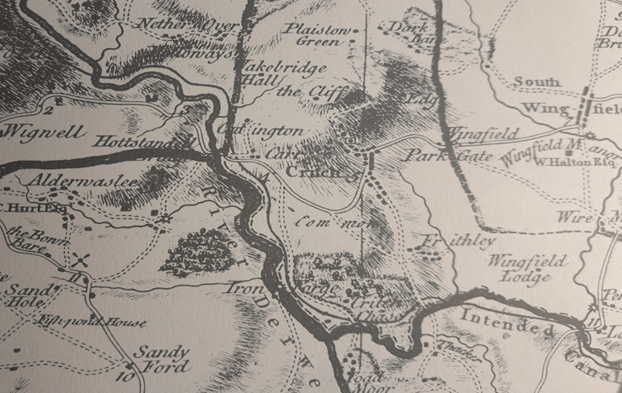
Burdett’s map (above), first published in 1767, is the earliest large-scale map of the roads around Crich, but even the revised 1791 version fails to show the Cromford/Langley Mill turnpike of 1766. The Oakerthorpe/ Ashbourne road is marked by a double solid line with mileages, minor roads are shown by double broken lines, but footpaths are not marked. Crich grew up at the junction of two ancient routes: one running roughly east-west from Alfreton to Ashbourne and the other north-south, from Belper to Cromford and Matlock. The fords (and later bridges) at Whatstandwell, Bullbridge, South Wingfield and Cromford determined the road pattern; in the past rivers were wider, wilder and more of an obstacle than they are today. Given the steep climbs, for example at Bullbridge, most of the freight traffic until the mid-eighteenth century would have been by packhorse. Other distinct routes fanned out from the river crossings but avoided Crich, such as the track from Whatstandwell Bridge which still climbs up through Duke’s Quarries to Wakebridge, and then higher to Shuckstone Cross and possibly on to Ashover or Chesterfield.

Little changed in this scenario until the arrival of turnpike roads in the second half of the eighteenth century. Turnpike trusts were allowed to charge road users (except travellers on foot) a toll, and in return had to improve and maintain the road surface to a suitable standard for wheeled traffic such as carts and coaches. The Cromford Bridge and Langley Mill turnpike, for example, was divided into six sections, with gates at Burgin Lane, Holloway, Hartsay and Peasehill Lane, plus chains at Codnor and Langley Mill. Although the tolls were widely resented, these upgraded routes encouraged the growth of industry, and travel generally in the period of the early Industrial Revolution.

By the mid-nineteenth century the improved roads had transformed life in Crich. Carriers ran a regular service of carts or waggons to Derby, Nottingham and Wirksworth. Several coaching inns, notably the Bulls Head (opposite St Mary’s) and the White Swan offered daily coach services throughout the north: The Champion to Manchester at 10.30 a.m., The Peak Guide to Buxton at 4.30 p.m., another service to Nottingham at the same time and to Derby at 5 p.m. When the Midland railway opened, an ‘omnibus’ ran four times a day to Ambergate station. Despite the new possibilities, most men in Crich still worked in the quarries, as lead miners, as framework knitters or in agriculture. However, Pigot’s Directory for 1835 lists two wheelwrights in the town, Thomas Hunt and John Smith, while Ralph Taylor was a sadler, while others worked as inn keepers.

Despite the centre of the town being called the Market Place, there is little evidence that a regular market was held there. However, Crich Fair was held twice a year, on the 6th of April (Lady Day) and 11th October (Old Michaelmas Day). It was originally for livestock, and was held on the Cromford Road above the Cross. By the early twentieth century it had become more of a fun fair with swings and roundabouts, but would still have generated local travel.
 The Old Roads of Derbyshire
Interesting, thanks SteveDave
LikeLike
Hi Steve, I really like your articles. I have heard you talk in the past, probably as part of the Wirksworth book festival. Do you still do talks? Im secretary of the Wirksworth Civic society and book our speakers. I’m looking at 2027 now. Would it be something you would consider? I would be happy to discuss. Thanks, Lyn ________________________________
LikeLike