Signposting the Peaks and Paths

Sign at the junction of five paths near Alderwasley

Many progressive social movements, such as the Cooperative Society, started in the Manchester area, and in 1894 this was the birthplace of one of Britain’s oldest footpath protection clubs, the Peak and Northern Footpath Society. Today it operates in Lancashire, parts of Yorkshire, Derbyshire, Cheshire and Staffordshire, with its headquarters in Stockport. Partly thanks to the pandemic, which drove so many people to explore their local areas, the society has become even stronger and more active, with over 1,300 members. To some extent this may also be the result of so many local authorities being unable or unwilling to maintain the footpath network.

An early model

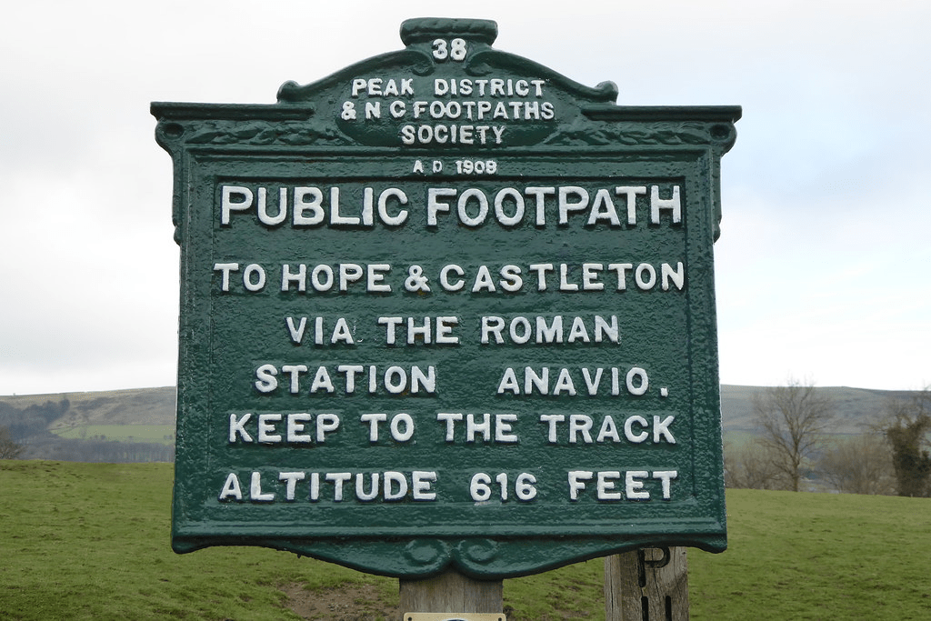
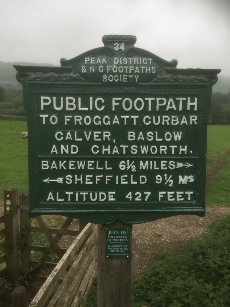
Originally founded to obtain access to the high moors of Kinderscout, the society developed a concern for all rights of way for walkers in its area. It soon started to mark these with its distinctive signposts, a vital reassurance at a time when many walkers could not afford maps (while map apps hadn’t even been dreamed of!) Today there are over 550 distinctive aluminium signposts scattered around the five counties, maintained by a team of dedicated volunteers. In fact the PNFS is entirely run by volunteers, a remarkable example of cooperative achievement. These volunteers include 172 footpath inspectors in 730 parishes who regularly walk the paths and report any faults to a path database.

Another popular route

Although a great deal of fuss is made of the so-called ‘Mass Trespass’ of 1932 the PNFS has been effectively defending the rights of walkers for well over 100 years, challenging planning applications and forcing landowners to open up paths that they were trying to block. In addition, the Society has also helped pay for many footbridges at crucial points of the path network, and organises a regular programme of long-ish (and longer) walks on both sides of the Pennines. A quarterly magazine, inevitably called ‘Signpost’ keeps members informed of developments. Why not join – it’s only £15 per year? See: http://www.peakandnorthern.org.uk/

Tolls, riots and Rebeccas

Toll cottage and toll gate at the National Museum of History in St Fagan’s.

Many toll houses survive in Derbyshire (see previous blogs) but the only surviving ensemble of cottage, gate and board of charges is found at the National Museum of Wales, near Cardiff. This was moved to the Museum from its original location near Aberystwith. The list of charges (see below) gives a fascinating insight into the traffic that used the turnpike roads in the early nineteenth century. Sixteen different kinds of horse-drawn passenger vehicles are listed, including chariot, Berlin, landau, chaise, phaeton, vis a vis and calash – all charged at six pence per horse (over £2 at modern values). Agricultural traffic was rated at four pence per animal, unless the cart was pulled by an ass, in which case it was only two pence. Droves of large animals like cattle cost the drover ten pence per score, while flocks of sheep were only five pence. It is easy to imagine the disputes that could have arisen about whether an animal was a cow or a calf (half price) or how many animals were in a drove!

The list of exemptions is also revealing. Farmers leading horses to work on the adjoining fields were free of charge, as were attendees at Sunday services, or funerals. Waggons carrying vagrants or prisoners were also free, as was military traffic and clergy doing parish business, sheep going to be washed and people taking part in county elections. Again, there seems to be plenty of scope for argument in such a lengthy list!

A contemporary image of the Rebecca riots

Despite these exemptions, ordinary people commonly hated the turnpikes, which seemed to take away a basic freedom – to use the ‘King’s highway’ without paying. This was especially the case in Wales, where an agricultural depression between 1839-42 caused widespread misery. This lead directly to the Rebecca riots, when protesters disguised themselves in women’s clothing and attacked and burned the toll gates, which had come to represent the general burden of taxation on the poor.

The Waters of Life and Death

Burycliffe Troughs, Elton

It is easy to forget the significance of a good water supply for both residents and travellers, something which is taken for granted today. But less than a century ago, up to 1940, the village of Elton was dependent for its water on Burycliffe Troughs, half a mile away, water which had to be laboriously carried by householders in buckets. Yet nearby Youlgrave had built its own water system in 1829, as indicated on its central cistern. Though this is not in use today, the village still maintains its independent supply, and provides it much cheaper than Severn Trent!

Youlgrave cistern

In nineteenth-century villages water was not usually piped to individual houses. Instead villagers collected it from wells scattered around, like this attractive example, also from Youlgrave, titled ‘The Gift’ and dated 1876. Similar examples can be found in many Derbyshire settlements.

The Gift, Youlgrave

Springs and wells had symbolic value in Christianity (and probably also in pagan beliefs). A late example of this is St John’s chapel in St John’s Road, Matlock Bath, a remarkable Arts and Crafts structure of 1895 built over a well, presumably a reference to St John as baptist. The stained glass windows also illustrate ‘The Waters of Life’ and ‘The Waters of Death’.

Well below St John’s chapel.

Many drinking troughs and wells can be found outside villages, as a critical part of the old transport infrastructure. The spring-fed example below, found near the top of the long climb out of Wirksworth and just below the Malt Shovel crossroads, would have provided a welcome drink for horses labouring up the incline, as well as for cattle and other animals being driven to and from market.

Drinking well on Wirksworth – Whatstandwell Road

Sadly, many of these wells have become choked with debris and allowed to dry up. It would be a positive addition to the landscape if they were cleaned and restored – and any passing horses would be very thankful.

Bridge building

Below Matlock bridge

In the current dry weather it’s quite easy to climb down and inspect the underside of the arches of Matlock bridge, a structure thought to date from the fifteenth century. As can be seen in the photo, this reveals a clear joint between the original structure and the widening carried out in 1904, which allowed two-way traffic on the bridge (since reduced to one-way in the latest traffic scheme). This is a reminder that most pre-twentieth century bridges would have only been wide enough for one cart or coach at a time, as is still the case with One-Arch Bridge at Chatsworth.

Holme Bridge north of Bakewell

Some were still narrower, such as Holme Bridge, on the River Wye upstream of Bakewell; just wide enough for a train of packhorses to cross. This is a reminder that bridge building was high skilled and thus expensive, yet bridges were absolutely critical to the transport network. The earliest bridges probably had a wooden superstructure resting on stone piers: easier to construct but liable to be washed away in any flood. All-stone bridges, with arches and breakwaters to deflect floating debris, were commonly constructed from the twelfth century but their cost was often met by a local monastery or abbey. In addition, tolls were frequently charged to pay for their upkeep.

St Mary’s bridge chapel, Derby

Important river crossing often had chapels attached, as with St Mary’s bridge in Derby (the only bridge in medieval times) or Cromford bridge (now ruined). The chapels would have provided a shrine for travellers to pray for a safe onward journey, and doubtless to leave an offering for bridge maintenance.

Bridge over River Bradford at Youlgrave

With most ancient bridges, establishing a date is almost as difficult as dating a road. The example above, with its simple round arch, and too narrow for a cart, could be anything from a hundred and fifty to a thousand years old, and would probably have been repaired many times after especially violent floods.

What’s going on at Wingfield?

The window of the Great Hall

The ruins of Wingfield Manor are an impressive sight, on a hill overlooking the River Amber and above the village of South Wingfield. The manor was only a mile west of the old Roman road known as Ryknield Street, from Derby to Chesterfield and Sheffield, still a major route but now the A61. This road would have been convenient for the second owners of the Manor, the Talbot family, Earls of Shrewsbury, who also owned Sheffield Castle and Sheffield Manor.

The buildings were deliberately ruined during the Civil War to prevent their use by Royalist forces, after a Parliamentary siege in 1644. Since the eighteenth century the structure has been effectively abandoned, although substantial ruins have survived. The most famous occupant was Mary Queen of Scots, imprisoned here for some years from 1569, in the care of the sixth Earl of Shrewsbury and his wife, Bess of Hardwick.

Mary Queen of Scots – all dressed up and nowhere to go

Clearly such an extensive ruin with famous associations should attract flocks of visitors. The Manor is in the ‘care’ of English Heritage (“unlimited access to hundreds of historic places” – website) but is firmly shut up, as it has been for several years. Their web page says:  ‘currently closed for the safety of visitors, and no public access is allowed’.  A meaningless statement that explains nothing.

Over a hundred years ago no such restrictions applied. DH Lawrence paid a visit at Easter 1905 with a group of friends, a visit which he fictionalised in his novel Sons and Lovers:

‘The young folk were in raptures. They went in trepidation, almost afraid that the delight of exploring this ruin might be denied them’.

Back entrance to the Manor

However, despite the best efforts of English Heritage, it is possible to get a good view of some parts of the ruin by following the public footpath around the back. Starting from the village and heading south, follow the track downhill, beside the garden wall of Wingfield Hall. Cross the stream at the bottom and bear right uphill. The ruins of the Manor can be clearly seen on the right.

Surprising Bradbourne

All Saints churchyard with cross

Halfway between Brassington and Tissington is the small village of Bradbourne, with a population of just over a hundred. Yet the substantial church was once part of a priory, and was the centre of a network of local chapelries. The church tower, complete with elaborately carved doorway, is Romanesque. while in the churchyard is a rare Saxon cross from about 800, showing a crucifixion scene. Why would such a small settlement have such rich monuments?

Crosses of this date are quite rare in Derbyshire: Bakewell and Eyam have good examples. Clearly older than the church itself, they may have signalled the conversion of the area to Christianity, and formed a base for preaching before the church was built. It is possible that such crosses were more common, but many may have been destroyed during iconoclastic periods such as the Reformation. Wirksworth, only a few miles away, would probably be the local minster church.

Doorway to tower with a variety of carved creatures

There is little sign that Bradbourne was ever on a major route. According to the parish council website, the north eastern parish boundary was the course of the Roman road from Little Chester to Buxton, but no source is given for this claim. However, this is now good walking country; the Limestone Way runs about a mile to the north, and to the south Haven Hill (partly access land) offers a convenient circular walk.

The two Williams

St Anne’s, Beeley

Diaries can be a useful source in studying travel patterns in the past. William Hodkin was a farmer and general dealer at Beeley, on the Chatsworth estate in the mid-nineteenth century. He kept a diary, mainly of his farming work, from 1864 to 1866, which reveals the shape of his trading network. Although the station at Rowsley was open at this time he made relatively little use of the railway, either riding on horseback or travelling with a cart when collecting or selling livestock or deadstock.

During two and a half months April to June 1864 he travelled to Bakewell 13 times, to Calton Lees 5 times, and to Chesterfield, Beeley Moor and Rowsley 4 times each. Other trips took him to Ashford, Matlock and Edensor. Interestingly, the state of the roads is never discussed: presumably he knew them all so well that there seemed no need to mention it, although he does once mention that his horse had collapsed on the steep hill to Chesterfield.

Hilltop House, Beeley, one of William’s regular destinations

It has to be admitted that William Hodkin was no Pepys. A typical entry (Thursday July 5th, 1864) reads: ‘Went rabbitting in the morning, making bills out at night. Father not doing much Thomas thrashing John carting stone to the highways’. This last job is a reminder that the roads around Beeley were not then tarmaced, and were still maintained by local labour. His wife is only referred to as ‘The Mrs’, although there are frequent mentions of the weather, and the occasional reference to the vicar’s sermon shows that William did sometimes take time off.

William’s landlord, William Cavendish, 7th Duke of Devonshire

Defoe’s Derbyshire tour

Biography of Daniel Defoe author of "Robinson Crusoe"
An early tourist

Few people living in Derbyshire in the eighteenth century have left an account of their travels; clearly they didn’t feel any need to describe their everyday experiences. Therefore it is left to the handful of early tourists to provide an impression of journeying in the county three hundred years ago. Daniel Defoe was an early novelist and journalist who visited many English counties in the 1720s in order to produce his A Tour of England and Wales.

Beginning at Derby, he had clearly chosen a wet season for his visit, since he had to abandon plans to visit Ashbourne on account of ‘the river drowning the low-grounds by a sudden shower, and hastening to the Trent with a most outrageous stream’, a reminder that, not so long ago, travel was very much at the whim of the weather. There are other references to the Derwent as ‘a frightful creature when the hills load her current with water’.

Cave at Harborough Rocks

Defoe’s next stop was Wirksworth, which he found interesting due to the lead trade, despite the inhabitants being ‘a rude boorish kind of people’. The most remarkable part of this visit was an excursion to Harborough Rocks, which was called the Giant’s Tomb at that time. Here he found a lead miner’s family living in a cave, which had been lived in by his family for several generations. Defoe was both horrified, and impressed that people could cope with such crude conditions: ‘they seemed to live very pleasantly, the children look’d plump and fat’. Defoe’s party had a whip-round and gave the miner’s wife several shillings. (Today the cave can be visited quite easily by climbing up from the High Peak Trail).

Other items on his itinerary were more predictable: the Wonders of the Peak, and a focus on spas, which were just beginning to be significant destinations at this time. He is suitably impressed by Chatsworth, but comments about the moor above the house: ‘a waste and howling wilderness, over which, when strangers travel, they are obliged to take guides, or it would be next to impossible not to lose their way’. As for getting to Matlock (which he labels as a village), Defoe maintains that the warm springs would be worth visiting if access was not by ‘ a base, stony, mountainous road’ – presumably the route over Scarthin, which was eventually superseded by blasting the present road through the rocks at Cromford.

Nineteenth-century painting of High Tor, Matlock

The Stonehenge of the north?

Arbor Low

Between Buxton and Youlgreave, high up above the Derbyshire dales, Arbor Low is the largest henge monument in the north of England. The November morning I visited was bleak and grey, with a keen wind from the west and a temperature barely above freezing. Unsurprisingly I was the only visitor when I arrived, although another car pulled up in the layby shortly after. I walked up the farm track for several hundred metres to where an English Heritage board gave some rudimentary information. There are two related sites here: the circular henge and Gib Hill, apparently a tumulus, a field away to the west. Then I walked up to the farmyard, where a small sign asked for a modest £1 for using ‘private land’.

Many farms in the Peak District are tatty; this one looked particularly run-down. A woman was pushing a wheelbarrow full of firewood through the yard – nobody else was around. The cattle were still in the fields, so the stall block was empty. There was a sign advertising‘B & B’ by the roadside, but I couldn’t imagine anyone choosing to stay in such a bleak location. Presumably they earn a few pounds a week from visitors’ contributions, but there was no attempt to offer tourist fare such as teas or postcards.

Beyond the farmyard Arbor Low is a circular bank containing a ditch and inside that over 40 stones, lying flat, with a few more stones at the centre. Impressive enough, especially given the situation, with a view of several miles in every direction. There are information boards at both the henge and the Gib Hill site, although these contain little actual information, beyond the standard visual recreations of scary looking people doing weird things. Apparently there has been no excavation here for a century, and so our knowledge of these places is even vaguer than usual with the prehistoric.

The contrast with the real Stonehenge is total. On Salisbury Plain coaches full of tourists, many from abroad, arrive every hour. There are lavish facilities for visitors, and a hefty £13.90 price tag to buy the timed tickets. Hundreds of visitors wander round the circle every hour. Scores of books and dozens of TV programmes have attempted to reveal the ‘secrets of the circle’. Yet, standing on the bank around the fallen stones, with an icy wind in my hair, I felt far closer to the past, whatever it contained, than I ever had in the south.

Burdett’s map of 1767 showing The Street north of Pikehall

Something not mentioned by English Heritage is that a Roman road ran through this area just 100 metres away, south east from Buxton, and that this probably followed the line of an older ridgeway. A henge monument on the scale of Arbor Low must have attracted visitors for (presumably) seasonal festivals from all over the district, and so the proximity of the henge to the road is not mere coincidence. It can be seen that the eighteenth-century turnpike did not follow the exact route of the older road, which remained in use until the time of Burdett’s map, but which has now disappeared except as a parish boundary. Overall the route presents a classic example of a road that may be at least four thousand years old, starting as a ridgeway serving the henge and other sites nearby, then being re-engineered by the Romans, and more recently re-routed as a turnpike road.

A life on the road

Tramps" — illustration for "The Uncommercial Traveller" by Sol Eytinge, Jr.

Tramps on the roadside in Victorian times

In contrast with the rich and powerful, whose historical journeys were often recorded, we know very little about the thousands of people in the past who made a living from being on the move. Some may have been semi-criminals, but the great majority supported themselves by providing a service; moving goods to where they were wanted. Yet the stigma attached to itinerant workers persisted; they were often seen as a threat to the settled householder or shopkeeper. For some, such as the drovers, it could be a profitable business, while others had no choice but to beg from village to village, relying on the kindness of strangers.

Well into the twentieth century tramps were a familiar sight on our roads, with George Orwell providing an unusual glimpse of their lives in his Down and Out in Paris and London. Written in the 1930s, he describes the grim conditions in the ‘Spike’, where workhouse-style accommodation was provided by the local authorities. Today, of course, the volume of traffic on the roads makes old-style tramping impractical, so that the destitute sleep rough in cities, where there is more food, money and shelter.

Gypsies and Caravan (Photos Prints Framed Posters Puzzles Cards Gifts  Canvas...) #20031226
A gypsy family in the 1930s

Gypsies, travellers or Roma are one marginal group that has attracted much interest and been heavily romanticised by writers such as George Borrow, while surviving into modern times. But others have been made redundant by the increase in personal mobility – we forget how isolated a Derbyshire village would have been up to the 1950s. Drovers were one of the most respected trades, responsible for the well-being of herds of valuable animals and their safe delivery to market. They would avoid turnpikes and use their own routes, with an overnight halt in an inn with grazing attached. Today it is difficult to trace droving roads, though place names such as Bullbridge may provide clues.

Probable west-east drove road near Minninglow

Pedlars (or travellers or hawkers) supplied the needs of isolated farms and cottages, in particular catering for women who could rarely visit a market town yet needed lightweight items such as sewing materials. They carried their goods in a pack, today commemorated in the name of the Hathersage pub, the Scotsman’s Pack. They must have been welcome visitors, but it is now hard to imagine how difficult their lives would have been, outdoors in all weathers and with the burden of the pack. Another significant group were the badgers or higglers, who bought goods such as eggs and butter from farmers and resold them at market. In theory they needed a licence to operate, so that for example in 1748 179 licences were issued at the Derbyshire Quarter Sessions, although many people may have operated unlicensed. As few, if any of these thousands of itinerant workers left a written record, tracing their lives is frustratingly difficult, but clearly their work was vital for the rural economy of the pre-motor age.