On the road to Dale

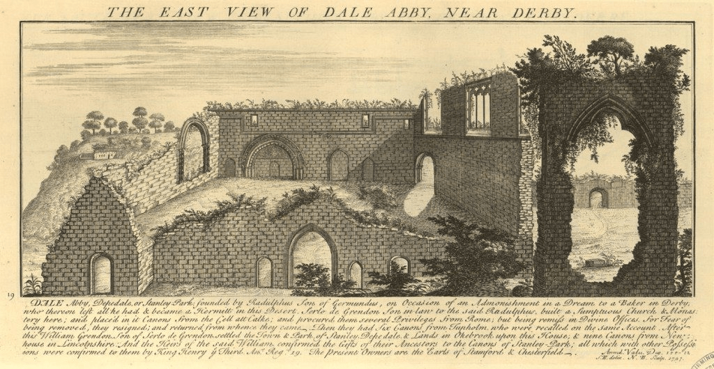
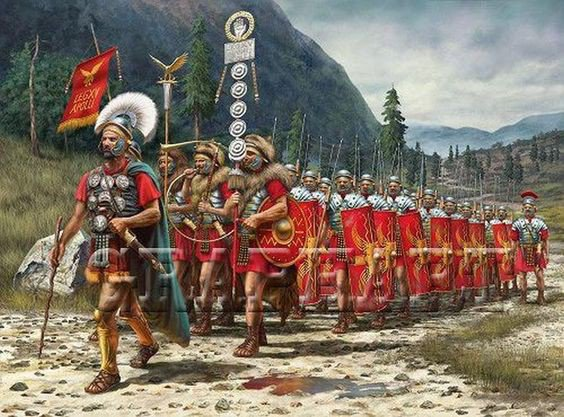
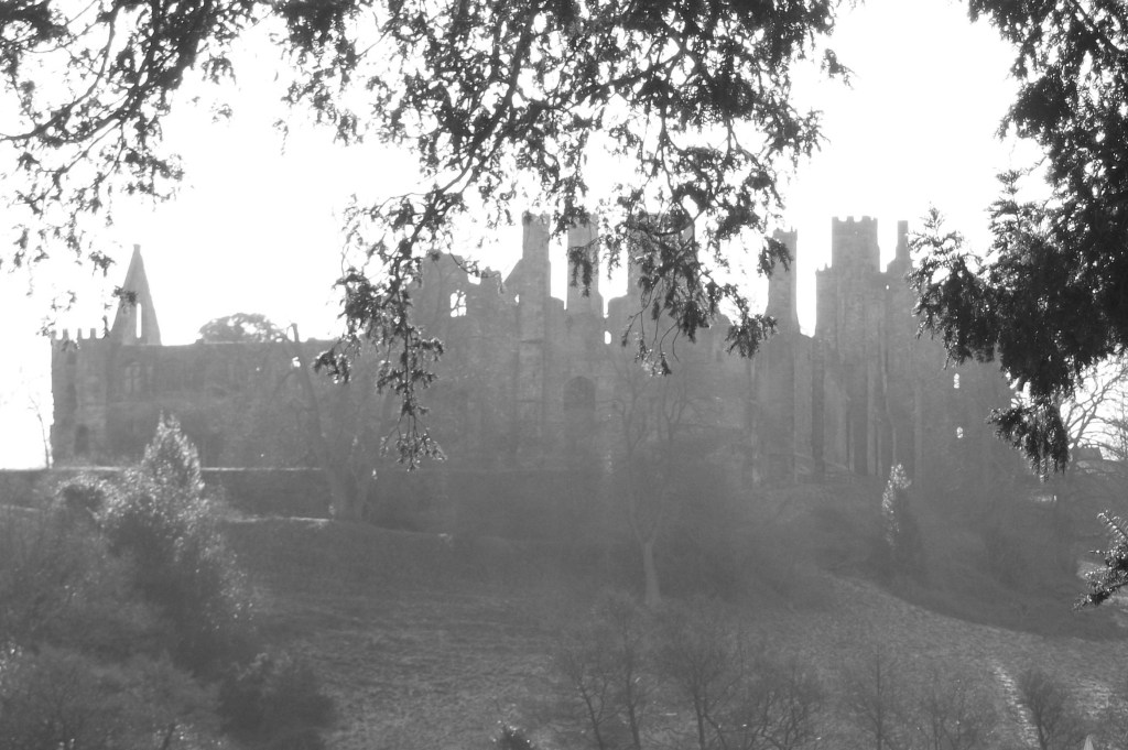
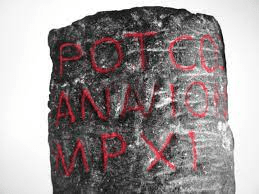
Compared with neighbouring Yorkshire, Derbyshire has hardly any visible remains of its abbeys. Even the location of Darley Abbey in Derby is uncertain, while Dale Abbey, between Ilkeston and Ockbrook, has just one solitary surviving arch (see below). The engraving above shows the state of the ruins in the eighteenth century, before the robbing of dressed stone had been completed. Yet at its height in the fifteenth century this abbey owned about 24,000 acres of land, throughout the county and beyond; endowments it had accumulated over the years. With only about 15 canons in residence, the job of administering these estates may have been given to lay people, but this task must have involved constant travelling. In addition, abbeys like Dale attracted pilgrims who came to pray before relics, in this case a phial of St Mary’s milk. For both reasons, Dale Abbey must have been sited on a good long-distance route.

The remains of the east window, Dale Abbey

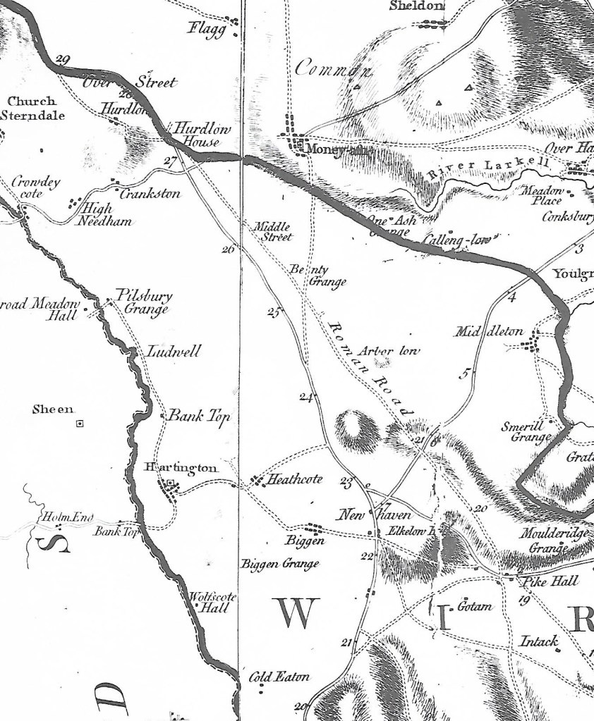
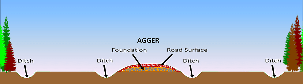
The conventional view is that monasteries and abbeys were sited in remote, inaccessible places where the inmates could spiritually benefit from the tranquility of isolation. That may have been true at one time, but the running costs of both the abbey and its agricultural lands meant that two-way traffic steadily developed. In fact Dale was on the route of the Derbyshire Portway, linking it directly with Nottingham to the east, and to the northwest with Wirksworth and its estates at Griff Grange just beyond that town (‘grange’ suggests a monastic farm).

Dale church today

Dale Abbey was closed in 1538 (by William Cavendish) and its huge estates, consisting of churches and mills in addition to moors, woods and fields were sold off. By this time the influence of Protestantism was undermining the twin ideals of the monastic life and pilgrimage. The buildings were soon pillaged: some stained glass, for example, being taken to nearby Morley church. Today the village of Dale provides good walking, one of England’s few semi-detached churches (another survival from the Abbey) and a remarkable hermitage above in the woods, supposed to have been created by a Derby baker who sought a religious life there in the twelfth century.

Chaps with maps

Part of Speed’s Derbyshire map of 1611: Wirksworth in centre.

It is a mystery of history that maps in the modern sense, as aids to travel, did not appear until the early eighteenth century. A few maps survive from the Roman and medieval periods, but they seem to have been rare and would not have helped the traveller. Presumably wayfarers simply had to ask the way. The first county maps of England, and probably the first in Europe, were produced by Christopher Saxton in the 1570s, and these were plagiarised by John Speed, whose 1611 Derbyshire map is shown above. This might have been of some use to travellers, although roads are not shown: the dotted lines are boundaries of hundreds. However his map does show rivers, some bridges (e.g. Belper bridge), and the fenced estates of the wealthy. Although it has the modern convention of north at the top it is still semi-pictorial in style, with little mountains and water mills. Note the erratic spelling: two versions of Wirksworth!

The first practical map for travellers was Ogilby’s strip map of 1675. As can be seen above, this maps the route from Derby (top right) to Manchester (bottom left), and shows villages, side roads, hills and some inns. This map is part of Britannia, a book of 100 major routes in the kingdom, at the innovative scale of one mile to an inch. However, this is the only Derbyshire road in the book, and it was not until 1767 that the whole county was surveyed for Peter Perez Burdett’s map (below). Although far from perfect, this is an invaluable reference for historians, depicting in detail the county’s villages, forests, and, for the first time, the main roads.

Burdett’s map of 1767 – the Derwent runs from top to bottom on right.

The map was revised in 1791 and so shows the turnpike roads (and mileages) as solid double lines. However, minor roads, lanes and paths are not marked. (The very thick black line is a hundred boundary). Upland is now shown by hatching, but it is obvious that the Via Gellia, west of Cromford, did not yet exist (or had not been recently surveyed). The names of some landowners are included, for instance Richard Arkwright at Cromford, and the maps were probably aimed at this class of customers, rather than ordinary travellers.

Ordnance Survey map of Youlgreave 1898: 25 inches = 1 mile

The first Ordnance Survey maps of Derbyshire, at a one inch to one mile scale, were not produced until 1840. Perhaps for the first time, accurate maps were available at a reasonable price. Later in the century larger scale maps were produced, such as the one above, which show every footpath, field and house, and so are a valuable resource for historians. Today we are so used to planning trips on cheap folding paper maps, or, increasingly map apps using GPS on our phones, that it’s easy to forget how recent these resources are. But perhaps the biggest mystery is how our ancestors moved around the country not only without maps, but without ever having seen a map in their lives?

“A fine lady upon a white horse …”

Woman riding side-saddle: No portrait of Celia appears to exist.

Celia Fiennes (1662-1741) was a well-connected lady who toured much of England on horseback around the end of the seventeenth century. Her journal provides a rare insight into the Peak District at this time, before turnpikes but when ‘tourism’ was just beginning. Although independent female travelers were rare at that time, her wealth allowed her to have two servants: an entourage that did not always protect her from the difficulties of travel. As the unmarried daughter of a Cromwell-supporting nobleman, Celia lived partly with a married sister in Hackney and seems to have traveled for both health and curiosity.

Woodcut of the old Buxton bathhouse

Like many more modern travelers Celia found much to complain of. At Buxton, where her party stayed at the Duke of Devonshire’s Buxton Hall, the beer was so bad that ‘very little can be dranke’. Worse were the bedrooms, which were overcrowded: ‘sometimes they are so crowded that three must lye in a bed’. Needless to say: ‘Few people stay above two or three nights it is so inconvenient’. It is easily forgotten that modern notions of privacy were quite foreign at this time. The main attractions were the bath and the water from St Anne’s Well. The former was about 40 feet long by 30 feet wide, and it was barely warm: ‘Just enough to open the pores of ones body’. Worryingly, the flow of water was weak, so that: ‘Its not capable of being cleansed after everybody has been in’. She must have questioned the health benefits of the process, but nevertheless plunged in.

Memorial to Celia in the (suitably named) No Mans Heath, Cheshire

Celia Fiennes visited the so-called ‘Wonders of the Peak’ in the same way a modern tourist might tick off the local attractions in their guidebook. But equally interesting are her comments on travel generally, which she seems to have found extremely difficult in this area:

Indeed all Derbyshire is but a world of peaked hills, which from some of ye highest you discover ye rest like steeples or tops of hills as thick as can be, and tho’ they appear so close yet ye steepness down and up takes up yr time…

Even the guides couldn’t be relied on:

The country here about is so full of moore or quagmires and such precipices that one that is a stranger cannot travel without a guide, and some of them are put to a loss sometymes.

Her journals were not published in her lifetime, but eventually appeared in 1888 with the title Through England on a Side-saddle. The full text can be found at:

https://l4.tm-web-01.co.uk/lib/celia-fiennes-M171235.webp

The Tunnel Road

Butterley and Ripley from Sanderson’s map of 1835

The Butterley Tunnel, shown on the map above, was one of the biggest engineering challenges in the construction of the 14 mile-long Cromford Canal, opened in 1794. Just over 3,000 yards (1.75 miles) long, the tunnel was only eight or nine feet wide, for reasons of economy. Clearly this did not allow space for a tow-path, and so the horses had to be walked over the hill, on the Tunnel Road which can be seen near the centre of the map. To avoid underground collisions there were strict rules for using the tunnel in different directions, for example barges travelling west could only enter the tunnel between five and six in the morning or one and two in the afternoon. They were expected to clear the tunnel in at least three hours. As the barges had to be ‘legged’ through, with the bargees lying on their backs, you can only hope they didn’t suffer from claustrophobia! The view of the eastern tunnel mouth today, below, gives an indication of how narrow the opening was, although when in use it would have been deeper than this photo sugests.

The Butterley Ironworks, a major factor in the growth of Ripley in the nineteenth century, was founded at the same time as the Canal was developed. Coal was mined from several pits in the area and iron ore was also quarried locally. The company went on to develop forges and blast furnaces at Butterley and Codnor Park. Clearly the canal was vital for the business, carrying both coal and finished products: an underground wharf still exists so that boats could be loaded directly below the Ironworks. One iconic product from Butterley was the steel frame of the roof of St Pancras Station.

At the end of the nineteenth century the tunnel suffered from mining subsidence, with rock falls, and was finally closed to traffic in 1900, so that the Cromford Canal, already suffering from railway competition, was cut in half. Today the Tunnel Road can be walked from the back of the Ripley Police HQ to Golden Valley, and several brick air shafts can be seen on the route. A path to the north of this road leads to the Britain Pit (photo above), whose winding wheel and engine house give an indication of the industrial past of the area. Sunk in 1827, this shaft is now part of the museum of the Midland Railway Centre, which operates trains on both standard and narrow gauge tracks nearby.

…and miles to go before I sleep

The Roman legions are supposed to have been capable of marching 20 miles per day. Even allowing for the Roman mile being slightly shorter than the modern mile, reducing the length to about 18 miles, this still seems very ambitious. It assumes they were walking on fairly well-surfaced roads rather than rough ground, but they must have been burdened by heavy equipment like shields. I imagine that this distance might have been possible in brief spurts, but for longer journeys something like 15 miles seems more realistic. However, the question of how far people could and did walk in a day is interesting, and can have surprising answers.

Looking down into Edale from Hollins Cross

There are many nineteenth-century examples of people walking remarkable distances to their work, especially in rural areas such as Derbyshire. It is easy to forget the complete lack of public transport in the days before bicycles became a practical solution. The 1851 Census records about 50 mill hands living at Castleton who worked at the cotton mill in Edale – their daily commute was about 3 miles each way but involved a climb of about 800 feet over Hollins Cross – in all weathers! Thomas Hardy’s novel Jude the Obscure describes Jude’s ten-mile walk to work as a stonemason; a figure which seems fantastic now but which must have been less remarkable when published in 1895. Even the walk to school could be arduous for children from outlying farms: Alison Uttley recalls her daily trudge from Castletop Farm near Cromford to Lea School, via Bow Wood – about a mile and a half each way. At the beginning of the twentieth century DH Lawrence, when a schoolboy in Nottingham, had to walk over two miles from his home in Eastwood to Kimberley station to catch a train into the town. As fictionalised in Sons and Lovers:

‘Mrs Morel was rather anxious about his health. But she herself had had to put up with so much that she expected her children to take the same odds’.

The romantic ruins of Wingfield

Lawrence also provides a good illustration of the popularity of hiking in the early twentieth century among the more radical working classes. For the first time, people had sufficient energy to go walking in their free time – something that would have been unthinkable for a labourer a hundred years earlier. In Sons and Lovers he describes a walk taken by a group of young folk, all from the Congregational Church in Eastwood, from Alfreton station via Crich to Ambergate station. Here he fictionalises an actual walk he led at Easter 1905, in which they visited Alfreton church, Wingfield Manor and Crich Stand (clearly not the present tower). On arrival at Whatstandwell:

They managed to procure a loaf and a currant loaf, which they hacked into pieces with shut-knives, and ate sitting on the wall near the bridge, watching the bright Derwent rushing by, and the brakes from Matlock pulling up at the inn’.

Given that all the walkers had to walk to and from the station at the start and end of the walk, the minimum distance they would have walked is about sixteen miles – a distance that would give many modern (and better-shod) hikers a real challenge!

Sources:

Robert Frost ‘Stopping by woods on a snowy evening’

Fletcher, A.J. (1971) ‘The Hope Valley in 1851’. Derbyshire Archaeological Journal 91:169-182

Lawrence, D.H. Sons and Lovers, Penguin, Harmondsworth, 1948

All roads lead to ….?

A street in the ruins of Pompeii

Pompeii may provide us with a good idea of what a Roman road looked like. Until its destruction in 79 CE Pompeii was a medium-sized town with good public facilities such as baths and temples – and well-paved streets complete with raised pavements. The photo shows the ‘crazy paving’ surfacing, kerb stones and also the ruts worn in the stone by carts with iron-rimmed wheels. In the distance blocks can be seen in the roadway to allow pedestrians to cross without getting too muddy. Perhaps the most surprising feature is the narrowness of both road and pavement – you wonder what happened when two carts met, or was there a one-way system?

Burdett’s Derbyshire map of 1767 showing The Street north of Pike Hall

The Street, the Roman road that ran between Wirksworth and Buxton, is one of the best examples of a Roman road in Derbyshire. Clearly marked as such on Burdett’s map, it was still in use in the eighteenth century before the Ashbourne-Buxton turnpike was built, although today there is little visible evidence of its route. The Romans would have used whatever building material was available, so in the Peak District there was plentiful stone for foundations and kerbs, although the surface was probably something like gravel. Their roads were generally constructed on an agger, a raised platform about two or more metres wide.

Roman milestone found in Buxton. It gives the distance to Navio as 11 miles.

The Street has been thoroughly researched by the Wirksworth Archaeological Society and various sections have been excavated. There has been endless debate about the southern destination of this route, and their research establishes that it reached Wirksworth, although the route beyond is unknown. The excavations also found that the road was no wider than two metres in places, so it should be seen as a relatively minor route, just wide enough for one wheeled vehicle. Given the number of pre-Roman sites which lie next to the Street, such as Arbor Low and Minninglow, it seems that the Romans actually followed and engineered a prehistoric route rather than create a brand-new road.

The theory

Although it is claimed that some stretches of Roman road survive in the Peak, for example near the Snake Pass, in fact it is impossible to know if these fragments are medieval or earlier. In general, over the last two thousand years almost all traces have vanished, due to weathering (stone tends to sink into the ground under its own weight; ditches fill up) and robbery of stone for wall or barn building.

Source:

The Street: A re-evaluation of the Roman road from Buxton to Wirksworth.

Wirksworth Archaeological Society, 2019

On yer bikes!

A group of Ripley cyclists about 1914

Bicycles only became practical transport in the 1890s, with the arrival of the chain-driven ‘safety cycle’ fitted with pneumatic tyres. Priced at about £12, for the first time they brought leisure travel within reach of the skilled working man or women – playing a significant role in female emancipation. Pioneering cyclists organised cycling clubs for weekend excursions, partly due to the state of the roads at that time, which caused frequent punctures. In the north the left-wing Clarion movement – strongest in Sheffield – organised a cycling association which held its first meeting at Ashbourne in 1895. Open to both sexes (unlike others) they saw their outings as an opportunity to spread socialist tracts around the countryside. Still in existence, the Clarion Cycling Club has (sadly) now dropped socialism from its masthead.

In the Edwardian period writers such as Thomas Hardy, HG Wells and DH Lawrence wrote of the pleasure and independence of cycling, which must have been greater at a time when cars were rarely seen. But a more recent writer has recorded his love of cycling from Nottingham into the Peak District. Alan Sillitoe (1928-2010) wrote that he first bought a bicycle at the age of 14, and headed for Matlock via Eastwood (before the modern A610 was built). He free-wheeled down to the Erewash and then pushed the bike up part of the hill to Codnor, ‘and many another walk with the bicycle before coming into Matlock’. Clearly his bike was lacking the gears that today’s cyclists take for granted!

Alan Sillitoe, author of ‘Saturday Night and Sunday Morning’

Sillitoe writes: ‘I’d go on Easter weekends through Bakewell and Buxton to Chapel-en-le Frith, and back to Nottingham via Chesterfield and Clay Cross, sleeping in fields and barns by the roadside, or under the lee of those rough stone walls, marking off the fields, thinking the hills beautiful and restful, but in no way hating the small hilltop mining towns and settlements when I got back among them … at Easter the road was often wet, and the wind could be bitter enough, but the real impulse was to wear out the body after a week in a factory, and reach as far a point from Nottingham as a bicycle could go in one weekend’.

Source:

Sillitoe, A. Lawrence and the Real England. A Staple Special (1985)

The Horsey World

A jolly holiday crowd at Matlock Bath

Today it is easy to forget the importance of the horse before the twentieth century. Leaving cavalry and racing aside, they were critical in agriculture and travel, reaching a peak in the nineteenth century when there were an estimated three million horses in Britain. Selective breeding during the medieval period led to horses replacing oxen in plough teams, while others were bred for speed and endurance. Travellers, unless poor, generally went on horseback, certainly before reliable coach travel was available in the 1830s. For many professions, such as doctors and lawyers, travel by horse was simply the most convenient mode, combining flexibility with reasonable speed, for long and short journeys. For example, James Clegg of Chapel- en-le Frith, a dissenting minister, rode nearly 1,000 miles in the first half of 1730, according to his diary.

Clegg’s chapel at Chinley near Chapel-en-le Frith

The ability to ride was necessary for these kinds of jobs, and gentlemen in particular were expected to ride with a certain style, especially when out hunting, or otherwise displaying their social status. When and how boys (and it was generally males before the modern period) learned to ride is a good question, and although there have always been riding schools, we can presume that most were taught by their fathers, or servants such as grooms. The population was mainly rural until the mid-nineteenth century, when riding ability would have been as common as knowing how to cycle is today.

Matlock Bath as was

DH Lawrence provides an example of this in his novel The Rainbow. Set in the 1870s, he depicts the young farmer Tom Brangwen riding from Cossall to Matlock Bath:

“One Whitsuntide he went a jaunt, with two other young fellows, on horseback to Matlock, and thence to Bakewell. Matlock was at that time just becoming a famous beauty spot, visited from Manchester and from the Staffordshire towns. In the hotel where the young men took lunch, there were two girls , and the parties struck up a friendship”.

In the story Tom gets off with one of the girls, tells his companions not to wait for him, and leaves his horse with an ostler while he takes the young lady for a walk in the woods. This is a reminder of the variety of jobs that were involved with the horsey world, such as ostlers, grooms, saddle makers and many more. The 1871 census for the parish of Matlock lists 12 wheelwrights, 15 blacksmiths, 17 cab drivers, 6 coachmen, 8 grooms, and 4 saddlers, not to mention a horse breaker, a coach maker and an ostler.

Cromford to Langley Mill in six gates

Toll cottage at top of Bullbridge Hill

The Cromford Bridge to Langley Mill turnpike wasn’t the snappiest name, but the road was intended to provide access to Nottingham from Cromford long before the current A6 route was built. Opened in 1766 it ran beside the Derwent from Cromford Bridge to Lea, then up Mill Lane to Holloway, along Leashaw to Wakebridge, through Crich (where it crossed the Alfreton-Ashbourne turnpike), and down the Common to Bullbridge. Here it went over and then under the Cromford Canal, through Sawmills to Hartshay, and via Ripley to Codnor and finally Langley Mill. At least two of the hills involved, particularly the one at Bullbridge, must have been challenging for horse-drawn traffic.

One of the distinctive cast-iron mileposts

As with many turnpikes, toll collection was auctioned off, and a notice from 1827 announces the annual auction at the (recently renovated) Canal Inn at Bullbridge, where bids for running the six gates had to start at £464, which sum was the previous year’s surplus. It is difficult to identify all the toll cottages today, but the one below, on Leashaw, and the house above, at the top of Bullbridge Hill, are clearly survivors. Until quite recently the Gate Inn, at Codnor Gate, was another reminder of the turnpike’s route. Today the road is still marked by these cast-iron mileposts (although not all have survived), though it seems likely that they are nineteenth-century replacements for earlier stones. It is not clear whether a traveller on the whole route would have paid at each gate, or as seems more likely, only once on exit.

Leaving Holloway via Leashaw today

Curiously this road has been much in the news recently: firstly when the section near Cromford was eroded by the flooded Derwent in 2019, leading to a three-year closure, and now this year when a section of Leashaw slipped downhill due to heavy rain, leaving the road closed to all but cyclists and walkers. The house on the left was the toll cottage for this stretch of the turnpike. Currently there is no date for re-opening the route, despite the inconvenience for local people and businesses, and as can be seen in the picture, nobody actually at work!

Reinventing the wheel?

The wheel is often cited as a critical invention in the development of our civilisation, and today wheels are so abundant it is difficult to imagine life without them. Yet they arrived in Britain relatively late – Stonehenge was built by a wheel-less society. The earliest wheel found so far, in Flagg Fen in Cambridgeshire, dates from about 1,600 BCE and is a solid wooden disc. The wheel above, from a museum in Avila, Spain, is over 3,000 years newer, and illustrates the complexity of making wheels almost without metal. It consists of five curved wooden sections, reinforced by a rim of five narrower pieces, all held together by ten spokes radiating out from a wooden hub strengthened by iron bands. Clearly the use of spokes makes for a much lighter wheel, reducing the effort for the carthorse.

These iron wheel rims were found in a chariot burial in northern Greece. They are thought to be Thracian, dating from the Roman period, and, remarkably, the skeletons of two horses were found in the tomb, buried in a standing position. The wooden part of the wheel has disappeared, but traces left in the soil show that it had spokes. Similar chariot burials have been found in Britain, notably in East Yorkshire, where a site at Pocklington in 2018 yielded the remains of a high-status burial of a chariot, thought to belong to the Iron Age (roughly contemporary with the Greek tomb), containing a man’s skeleton, along with the bones of two horses.

Wheeled vehicles such as carts, waggons and coaches were historically less common in north Derbyshire, due to the steep, poor roads and use of packhorses. However, for working lowland farms and for market journeys carts were more efficient than packhorses, needing only one horse to carry a ton of goods. With the improvements in road surfacing brought about by turnpike roads in the second half of the eighteenth century, all major Derbyshire towns were connected by regular coach services by the early nineteenth century. The picture above shows a passenger-carrying brake or charabanc outside the Sun Inn at Buxton, perhaps waiting for a tourist party to finish their lunch?