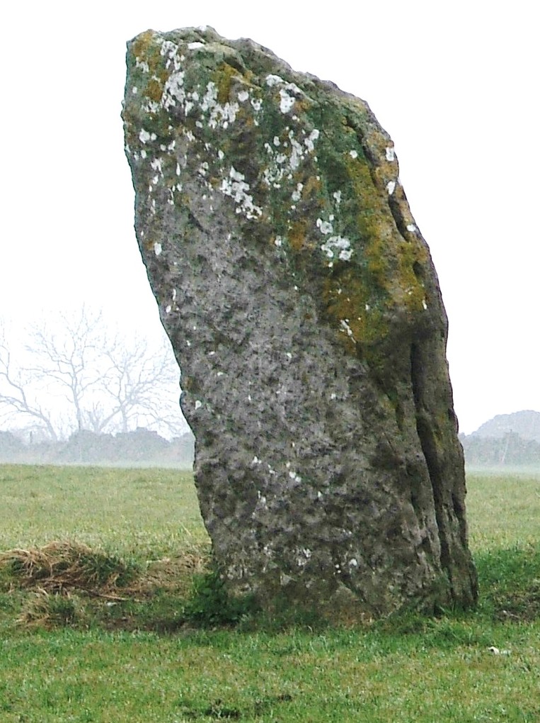
Hermits and their hermitages

Sneinton Hermitage

Hermits are generally imagined to be solitary recluses, who adopted an isolated life to focus on spiritual matters. Yet little is known about the lives of individual hermits, which are first mentioned in Britain about 700 CE. Most surviving ‘hermitages’ are natural or man-made caves, and a remarkable feature of our region is the four hermitages on the route of the Portway; two in Nottingham and two in Derbyshire. This distribution suggests that the hermits who lived there helped travellers on the road, either with practical information or possibly with their religious issues. Hermitages were sometimes linked to a monastery or abbey, and in our case one was connected with Lenton Abbey west of Nottingham, while Dale Hermitage was a forerunner to Dale Abbey, built close by.

Nineteenth-century painting of ‘druidical remains’, Nottingham by W. Bradbury

Sneinton Hermitage, a mile east of the centre of Nottingham, is cut into the sandstone rock on which much of the town was built. It is now protected by steel railings, and was apparently larger before the site was developed by railway construction. Travellers disembarking from boats on the River Trent would have approached the town this way.

The second hermitage, illustrated in the painting but wrongly described as ‘druidical remains’, is now on private ground behind a modern block of flats on Castle Boulevard. Hermitage Walk, a street in the Park above, used to give access to the caves, which, judging by the painting, were given a parkland setting at some point. The most unusual feature of this group of caves is a rock-cut chapel known as St Mary de la Roche, which may have been the work of friars and could have been a pilgrimage centre before the site was acquired by the monks of Lenton Abbey in the thirteenth century.

Dale Hermitage

The third hermitage, and the most accessible, is in an idyllic woodland setting near Dale in southeast Derbyshire. At this point the Portway descends a steep slope, and a hermit could have given travellers practical guidance. The photo shows a series of holes cut in the rock face above the door, which presumably allowed a wooden extension to be built in front of the cliff face. According to legend, a Derby baker was told in a dream to come and live in Depedale, and he was the predecessor to the monks who established the Abbey, now almost entirely demolished, in about 1200 CE.

Cratcliffe crucifix

Cratcliffe Hermitage can be found by forking off the main path up to Robin Hood’s Stride on Harthill Moor. It’s a bit of a scramble to reach it, but the position is spectacular, looking back over the Portway towards Winster. The rock opening is flanked by two old yew trees, presumably planted in the nineteenth century, and railings protect the remarkable carved crucifix on the wall inside. Unusually, there is a record in the accounts of Haddon Hall (only two miles away) of the hermit selling rabbits to their kitchen in 1550, so apparently he had survived the Dissolution of a few years earlier.

Taken together, these four sites provide a possibly unique insight into the reality of medieval travel. Among the various types of wayfarers would have been pilgrims, heading for shrines in Dale or Lenton Abbeys, who may have supported the hermits in return for their prayers for a successful journey. Other travellers would have been glad of information about the next stage of the journey, and possibly suggestions about where to find food and shelter for the night.

Cromford Bridge

Upstream view of bridge

It is easy to forget how crucial bridges were to the medieval traveller, who could otherwise be delayed at a ford for days, waiting for the river to be passable. Many bridges, including Cromford, were probably originally timber structures with stone piers.

The name ‘Cromford’ means a ford on a (river) bend, and it seems likely that the ford was roughly in the same place as the bridge, just below the point where the Derwent curves out of Matlock Bath. This must have been a vital crossing point, linking the route descending Cromford Hill from Wirksworth and beyond with the road to Starkholmes and old Matlock, plus the older route up along Hearthstone Lane, and the road to Lea Bridge going through Bow Wood.

Dating bridges is always difficult since most have been widened and frequently repaired. In this case it can be seen that the arches are pointed on the upstream side, but more rounded on the downstream, suggesting a substantial rebuild from an original packhorse width. It is generally thought to be fifteenth century, but may be older.

What makes this bridge so special are the ruins of a bridge chapel on the west bank – not to be confused with the later fishing house. Bridge chapels were built to allow travellers the chance to pray for a safe journey and perhaps leave an offering for the upkeep of the bridge. Only a handful survive in Britain, and this example may have been built at the same time as the bridge. It became ruined after the Reformation, but was excavated and repaired by the Derbyshire Archaeological Society in 1951.

Next door to the chapel ruins is the more recent fishing lodge, which has very recently been given a new stone roof. Over the door is the inscription ‘Piscatoribus sacrum’ meaning sacred to fishermen. It may well have been built by the Arkwrights, possibly for their water bailiff. Their grand house, Willersley Castle, dominates the view on the opposite side.

The fishing lodge

Another, easily overlooked feature of this busy bridge is a stone inscription ‘THE LEAP OF MR B H MARE JUNE 1697’ on the southern parapet, marking the spot where a Benjamin Hayward leapt on horseback from the bridge into the river. Presumably the river was in full flow at the time as apparently both horse and rider survived.

Mare’s leap

The bridge is near the terminus wharf of the Cromford canal, opened in 1794. But it was also the rather unlikely starting point of the Cromford Bridge and Langley Mill turnpike road, which ran from there along the east bank of the river towards Lea Bridge, and then on to Holloway, Crich and Bullbridge. This road seems to have opened in the early nineteenth century, and would have provided a faster link with Nottingham and district, replacing the old hilly route past Castletop and through Bow Wood. This is the road which was badly affected by flooding in late 2019 and has been closed ever since.