Beating the bounds

Boundary stone near Fritchley

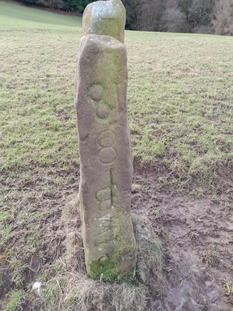
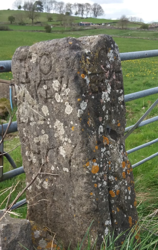
This stone, partly broken, can be found lurking in the hedge of the minor road that links Fritchley with Wingfield. Although partly broken, one side still reads ‘Winfiel(d)’ and the other ‘Crich’. Easily mistaken for a milestone, this is actually a boundary stone marking the limits of these two parishes, marked BS on Ordnance Survey maps. The boundary here can still be followed on public footpaths, southwards to a footbridge over the River Amber and Sawmills, northwards (briefly) to Park Head. The OS maps mark the boundaries with black dots, though they can be difficult to see.

A custom revived

The parish system of local government is thought to have been established in Saxon times, although individual parishes were originally much larger. In the past, parishes were the only kind of local authority that affected most people’s lives, being responsible, for example, for road maintenance. Therefore the limits of the parish were important, and in a largely pre-literate society this knowledge had to be handed down orally, hence the annual perambulation known as ‘Beating the Bounds’. This involved the priest, various landowners and some unfortunate young lads, whose fate was to be beaten at critical points so they would remember them. Who knows whether this beating was symbolic or real?

Another stone in North Derbyshire

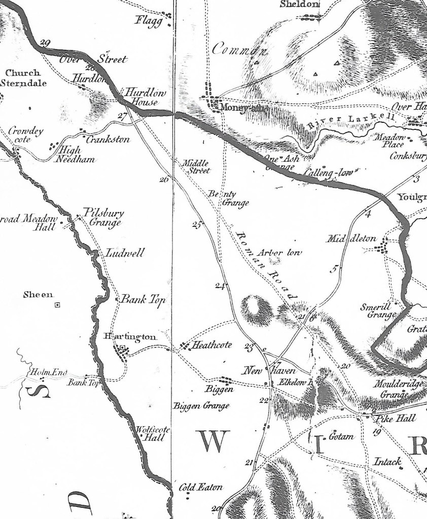
Rivers and streams were often used as boundaries, since they were unlikely to move very much, but as they were not always available other marks, such as large trees, might be used, and clearly boundary stones were sometimes also needed. Where the line of a road (or footpath) is a boundary it suggests that the road is very ancient and important, such as sections of the old Roman road (The Street) running north from Pikehall, which was in use for at least 1,500 years. Today the custom of bounds beating is obviously redundant, but in places it has been revived as an enjoyable excuse for a group walk, as in the Macclesfield example above. More locally, a WEA group from Crich re-enacted the ceremony in 1984, and produced a very helpful written account of their route around the 14 miles of the parish boundary. See: https://www.crichparish.co.uk/PDF/beatingbounds.pdf

Mystery stone

Any offers?

Walkers in the Peak District come across standing stones of various types. The banal gatepost often remains after a wall or hedge has disappeared, and can be identified by the hinge posts which were often fixed in their holes by molten lead. More ancient, crudely shaped stones appear to have been route markers (see previous blogs). Eighteenth century guide stoops are clearly distinguished by the names of the towns carved on each of the four sides. But the stone above, which I found just 100 metres off the Limestone Way, in between Harthill Moor Farm and Youlgreave, is none of these.

1888?

The stone is about four feet high and rectangular, with a square hole cut right through, and the suggestion that it might have been taller, with a piece broken off the top. The inscription is only on one of the narrow sides, and might be the date 1888. Lower down there appears to be a ‘W’. The parish boundary runs along a nearby stream (Bleakley Dike), which may offer a clue as stones were often used as boundary markers, though it’s still not clear why anyone would go to the trouble of cutting the hole. I’d be glad to see photos of anything similar, or suggestions about the function of this one!

Goodbye to another pub?

The Jug and Glass at Lea Green, pictured above, is the latest in a long list of Derbyshire pubs that have closed in recent years. Just in the Matlock area these include the Lime Tree and the Crown in Matlock itself, the Jovial Dutchman and the King’s Head in Crich, the Yew Tree in Holloway, the Nelson at Bullbridge, the Derwent Hotel at Whatstandwell, the Homesford Cottage on the A6, the George and the Vaults in Wirksworth, and many more. So what accounts for this spectacular collapse of what is still seen as an important English institution?

For sale in Chesterfield – The historic Royal Oak

Although pubs are now seen mainly as a community resource and valued for providing a meeting space for local clubs, inns (as opposed to alehouses) originally catered to travellers, and provided meals, beds and a change of horses, as well as drink and company. Inns must certainly date back to Chaucer’s time (c. 1370), since his pilgrims stay at the Tabard in Southwark, and are probably much older. But the arrival of railways reduced their importance, and drink drive legislation was a further blow. Today’s traveller is lucky to find any wayside pub or inn open, since so many have had to restrict their opening hours.

The classic look

There are many reasons for the recent decline in pub-going. The price of beer, pushing £5 a pint in places, and the shortage of staff willing to work unsocial hours, made worse by the folly of Brexit, all contribute. But perhaps the critical factor has been the reluctance of many to enter a communal space, which was exacerbated by the pandemic. ‘Pub’ stands for public house, which means a place where you can meet your neighbours on neutral ground. Yet it seems that more and more people prefer to drink in the safety of home, where the drinks are cheap, and there’s no danger of having to talk to a stranger.

All roads lead to ….?

A street in the ruins of Pompeii

Pompeii may provide us with a good idea of what a Roman road looked like. Until its destruction in 79 CE Pompeii was a medium-sized town with good public facilities such as baths and temples – and well-paved streets complete with raised pavements. The photo shows the ‘crazy paving’ surfacing, kerb stones and also the ruts worn in the stone by carts with iron-rimmed wheels. In the distance blocks can be seen in the roadway to allow pedestrians to cross without getting too muddy. Perhaps the most surprising feature is the narrowness of both road and pavement – you wonder what happened when two carts met, or was there a one-way system?

Burdett’s Derbyshire map of 1767 showing The Street north of Pike Hall

The Street, the Roman road that ran between Wirksworth and Buxton, is one of the best examples of a Roman road in Derbyshire. Clearly marked as such on Burdett’s map, it was still in use in the eighteenth century before the Ashbourne-Buxton turnpike was built, although today there is little visible evidence of its route. The Romans would have used whatever building material was available, so in the Peak District there was plentiful stone for foundations and kerbs, although the surface was probably something like gravel. Their roads were generally constructed on an agger, a raised platform about two or more metres wide.

Roman milestone found in Buxton. It gives the distance to Navio as 11 miles.

The Street has been thoroughly researched by the Wirksworth Archaeological Society and various sections have been excavated. There has been endless debate about the southern destination of this route, and their research establishes that it reached Wirksworth, although the route beyond is unknown. The excavations also found that the road was no wider than two metres in places, so it should be seen as a relatively minor route, just wide enough for one wheeled vehicle. Given the number of pre-Roman sites which lie next to the Street, such as Arbor Low and Minninglow, it seems that the Romans actually followed and engineered a prehistoric route rather than create a brand-new road.

The theory

Although it is claimed that some stretches of Roman road survive in the Peak, for example near the Snake Pass, in fact it is impossible to know if these fragments are medieval or earlier. In general, over the last two thousand years almost all traces have vanished, due to weathering (stone tends to sink into the ground under its own weight; ditches fill up) and robbery of stone for wall or barn building.

Source:

The Street: A re-evaluation of the Roman road from Buxton to Wirksworth.

Wirksworth Archaeological Society, 2019

Cromford to Langley Mill in six gates

Toll cottage at top of Bullbridge Hill

The Cromford Bridge to Langley Mill turnpike wasn’t the snappiest name, but the road was intended to provide access to Nottingham from Cromford long before the current A6 route was built. Opened in 1766 it ran beside the Derwent from Cromford Bridge to Lea, then up Mill Lane to Holloway, along Leashaw to Wakebridge, through Crich (where it crossed the Alfreton-Ashbourne turnpike), and down the Common to Bullbridge. Here it went over and then under the Cromford Canal, through Sawmills to Hartshay, and via Ripley to Codnor and finally Langley Mill. At least two of the hills involved, particularly the one at Bullbridge, must have been challenging for horse-drawn traffic.

One of the distinctive cast-iron mileposts

As with many turnpikes, toll collection was auctioned off, and a notice from 1827 announces the annual auction at the (recently renovated) Canal Inn at Bullbridge, where bids for running the six gates had to start at £464, which sum was the previous year’s surplus. It is difficult to identify all the toll cottages today, but the one below, on Leashaw, and the house above, at the top of Bullbridge Hill, are clearly survivors. Until quite recently the Gate Inn, at Codnor Gate, was another reminder of the turnpike’s route. Today the road is still marked by these cast-iron mileposts (although not all have survived), though it seems likely that they are nineteenth-century replacements for earlier stones. It is not clear whether a traveller on the whole route would have paid at each gate, or as seems more likely, only once on exit.

Leaving Holloway via Leashaw today

Curiously this road has been much in the news recently: firstly when the section near Cromford was eroded by the flooded Derwent in 2019, leading to a three-year closure, and now this year when a section of Leashaw slipped downhill due to heavy rain, leaving the road closed to all but cyclists and walkers. The house on the left was the toll cottage for this stretch of the turnpike. Currently there is no date for re-opening the route, despite the inconvenience for local people and businesses, and as can be seen in the picture, nobody actually at work!

Traveller’s Tree

The yew tree in St Helen’s churchyard at Darley Churchtown is a well-known example of an ancient tree in a sacred setting. Growing near the west church porch, it is 33 feet in girth (which makes it hard to illustrate clearly), and is estimated to be 2,000 years old. Clearly it pre-dates the (twelfth-century) church, suggesting that this was a significant site even possibly in pre-Roman times. Certainly the nearby river crossing at Darley bridge has been part of an important west-east route for thousands of years.

There has been much speculation about churchyard yews, such as the idea that they were grown to provide wood for longbows, but their great age suggests a less prosaic function, as markers of significant sites for travellers.

The Darley yew is not the only ancient one in the county. The yew at St Edmund’s, Allestree may have given the name to the village, suggesting that the tree was already sizable when ‘Adelard’ had his settlement there. There are others at Beeley, Brailsford, Doveridge, Marston Montgomery and Muggington.

The Old Yew Tree, South Wingfield

Although native, the yew is not a common species in Derbyshire. However, it appears to be quite a common name for pubs and farms: with pubs at Dronfield, South Wingfield, Ednaston and (sadly now closed) Holloway. In some cases there is a yew growing on site – it would be interesting to know which came first, the tree or the pub? Pubs and inns were clearly important for travellers in the past, and before inn signs were displayed inn keepers hung an evergreen bush outside their door – usually holly or yew. This is the origin of the saying ‘A good wine needs no bush’. There are currently five Hollybush pubs in Derbyshire, at Grangemill, Makeney (which claims to be one of the oldest pubs in the county), Ripley, Breedon-on-the Hill and Church Broughton.

The Thorn Tree, Ripley

The most common pub tree name is the Royal Oak, which is the third most popular pub name in England. However, this is really a Royalist-type name, commemorating the escape of the future Charles II from Parliamentary troops by hiding up an oak. Other ‘tree pubs’, in descending order of popularity, are: Orange, Walnut, Pear, Oak and Cherry. It is notable that Matlock has a good variety of such pubs, all with rather unusual names: Thorn Tree, Laburnum, Sycamore and (until recently) Lime.

Sources

The Sacred Yew, Chetan and Brueton (1994)

The Place-Names of Derbyshire, Cameron (1959)

Wayside worship

Altar to the Quadruviae in Germany

For at least two thousand years European roads were marked by shrines and sanctuaries, giving travelers the chance to rest, make offerings and pray for a safe journey. The Romans dedicated some to well-known gods such as Hercules and Mars, but they also had divinities specific to travel: Biviae at the meeting place of two roads, Triviae for three and Quadruviae for four, as in the example above, found in Germany. These junction divinities were all female, and give us some insight into the mindset of the ancient world. Even in medieval times in England a crossroads was seen as a place of significance, suitable for the burial of suicides (finally abolished by act of parliament in 1832).

Roadside scene (detail). Eighteenth century

The painting above, in the Thyssen Museum in Madrid, provides a rare glimpse of what may have been a common sight in the pre-industrial world: at a small stone shrine one man is on his knees, while another, on horseback, makes an offering. Yet in Catholic areas of Europe this tradition continued into the twentieth century, as described by DH Lawrence in his essay ‘The Crucifix across the Mountains’. In 1912 Lawrence and Frieda made an epic journey, mainly on foot, from Bavaria to Lake Garda in Italy. Lawrence was struck by the carved wooden crucifixes they found by the roadside:

Coming along the clear, open roads that lead to the mountains, one scarcely notices the crucifixes and the shrines … But gradually, one after another looming shadowily under their hoods, the crucifixes seem to create a new atmosphere over the whole of the countryside, a darkness, a weight in the air …

Wheston Cross near Tideswell

Derbyshire roads had their share of shrines, although little is known of pre-Christian examples. However, it is difficult to judge which of the surviving crosses were boundary markers and which were wayside crosses. At the reformation in the sixteenth century the crosses, usually dedicated to a saint, were generally destroyed as being Popish. However, a few survived, such as the cross at Wheston, which has the Madonna and Child on one face and the Crucifixion on the other. It is about 11 feet tall, but part of the shaft is more recent. Such crosses must have helped travelers navigate generally, but may also have been used to point the way to pilgrimage churches. One clue to the previous existence of a cross is the name ‘Cross Lane’, found in various locations in the county, such as just above Dethick. The topic is fully explored in Neville Sharpe’s ‘Crosses of the Peak District’.

Baslow and beyond

East end of Baslow old bridge

Driving on the busy A623 through Baslow today, it is easy to miss the medieval bridge next to St Anne’s church. Yet this was part of an important route in the eighteenth century: carrying the turnpike from Monsal Head to Chesterfield, while before then it carried packhorse traffic heading for East Moor and Sheffield. In 1500 an order was issued forbidding the carriage of millstones over the bridge; presumably their weight was damaging the earliest structure (which may have been wooden at that date). The small stone hut at the end of the bridge is sometimes called a watchman’s shelter, but elsewhere it is presumed to be for a toll collector. However the entrance is so low it is hard to imagine how this would work, unless the job was given to a child!

Lady Well, Bar Road

The old route can be followed from the bridge by crossing the main road and following School Lane uphill. This takes you through the heart of the old village but then continues more steeply uphill as Bar Road. Although this name may suggest a barrier or turnpike, according to Dodd and Dodd (1974) Bar was a name widely given to tracks that led down from the moors. Rather confusingly, Burdett’s map of 1762 tautologically names the river that flows through Baslow into the Derwent ‘River Barbrook’. Higher up Bar Road, beyond the houses, is the Lady Well, providing a welcome drink for travellers and their animals before climbing the last stretch up onto the moor. Once on the top, various landmarks such as the Eagle Stone and the Wellington Monument provide guidance.

Painting of the old bridge

The mystery of the milestone

Milestone near Tissington

Walking near Tissington the other day I stopped for a drink of water, and propped my walking pole on what I took for an old gatepost, embedded in the rather ragged hedge. Then I realised it wasn’t a gatepost, but was inscribed on the side facing the lane. The inscription was finely carved, in serif lettering, but was difficult to read, being partly covered in moss. I finally decided it reads, in part:

From

London

(illegible)

Miles

(Illegible)

Guide stoop above Winster

Clearly this was not a guide stoop, which, as the example above shows, were inscribed on all four sides with the distance to the nearest market towns. The Tissington stone seems to only show the distance to London – not the most useful information for the traveller here. Moreover, it is located on a lane running east to the ford and nearby Bradbourne Mill, which seems an unlikely route to London: the obvious way to the capital was via Ashbourne and Derby.

Distance marker, corner of town hall, Wirksworth

Another, much later example of a marker showing the distance from London is found in Wirksworth, by the town hall. This version also gives the mileage to key towns on local turnpike routes. Again few travellers would have needed to know how far they were from London, but the marker does link the local community to the prestige and glamour of the capital. Could this be the motive for the Tissington stone – to associate this remote village with the majesty of London?

Any better ideas welcome!

Love in the slow lane

The Long Engagement’ by Arthur Hughes (Birmingham Art Gallery)

Before the mid-twentieth century many homes were overcrowded, with a lack of privacy that would surprise younger people today. Furthermore, parents were often inclined to supervise their children’s indoor behaviour, so that most ‘courting’ took place out of doors, away from adult eyes. This applied equally to middle-class people: in the Hughes’ painting above a curate is meeting his fiancee in the woods, where ivy has grown over their initials carved into a tree, symbolising their lengthy enforced wait until he can afford to marry.

Path from Crich to Chadwick Nick

Most towns and villages would have had a ‘lovers’ lane’ where courting couples could find some privacy, as in the Crich footpath above, which still has boulders carved with sets of initials. Suitable venues would not be too far from habitation, nor the paths too rugged for girls dressed in their best! The situation is well-described by DH Lawrence, always an honest depictor of working-class life at the turn of the twentieth century, in ‘Sons and Lovers’, when Paul and Clara take the Clifton path by the River Trent:

He held her fast as he looked round. They were safe enough from all but the small, lonely cows over the river. He sunk his mouth on her throat, where he felt her heavy pulse beating under his lips. Everything was perfectly still. There was nothing in the afternoon but themselves.

Statue of Lawrence at the University of Nottingham

Lawrence’s early stories and novels also give us a good idea of what were then acceptable distances for walking, either for work or pleasure. In 1905 public transport was limited and bicycles were only for wealthier people. On another occasion in ‘Sons and Lovers’ Paul and Clara are out in the hills after dark and she says that she needs to hurry back to the station to get the last train home to Nottingham. He says:

‘But you could easily walk it Clara, it’s only seven miles to the tram. I’ll come with you’.

It’s hard to imagine any contemporary lover thinking that an extra half hour with their darling was worth a two hour walk!