The lost fords of the Derwent – 1

Railway bridge on Ladygate leading to Old Matlock

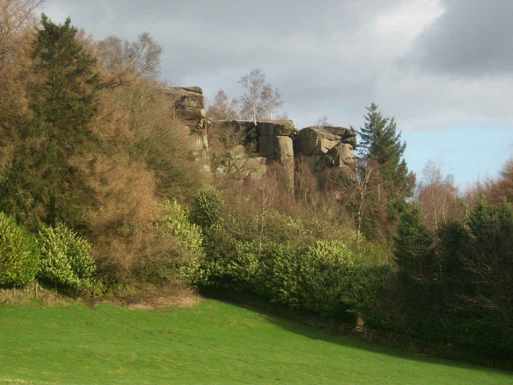
River crossings have always been critical points on the road network, and originally these would have been fords, passable for riders in normal conditions, and possibly having stepping stones for those on foot. From medieval times onwards fords on the Derwent were mainly replaced by stone bridges, though their location is still remembered by the place names Bamford, Grindleford, Cromford, Homesford and Milford (from north to south). The original name for Matlock appears to have been Mestesforde (i.e. in the Domesday Book), and many historians have assumed that this ford was near the site of the current bridge. But the nucleus of old Matlock is actually at Starkholmes, not near Crown Island, and so it has been argued that the ford was near the point where Ladygate Lane now crosses the river on a footbridge.

Well below St John’s Chapel

The westward route would have climbed up the hill, past the nineteenth century St John’s Chapel (built over a perpetual spring), and up to Bonsall, near where it linked up with Salters’ Way. The more modern route of Salters’ Lane, leading to Matlock Bridge, developed after this bridge was constructed, although the date of the original bridge is not clear. The access to the bridge on the east side was easy, but because this land (i.e. Hall Leys) flooded regularly (and still does) development may have continued around St Giles for some time.

The site of Homesford from Sanderson’s 1835 map

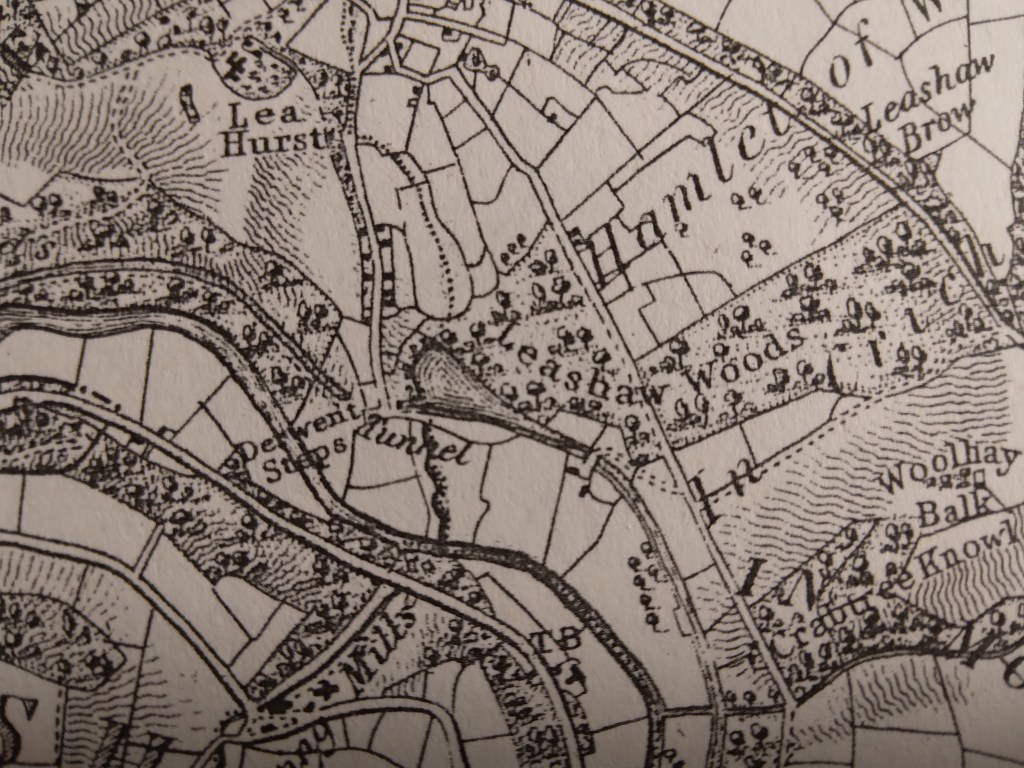
A few miles downstream, the Homesford Cottage pub (still advertised as selling Kimberley Ales) has become a guest house, and the name Homesford is not found on the OS map. Yet Sanderson’s map from 1835 shows a road from Upper Holloway running down past Lea Hurst (Florence Nightingale’s home) and over Gregory Tunnel on the Cromford Canal. The name ‘Derwent Steps’ by the river suggests a well-established set of stepping stones, with presumably a ford beside for carts and livestock. Today the Derwent can still be crossed here on a footbridge, suggesting that this was an ancient route, but there is no sign of any steps in the currently fast-flowing, turbulent river!.

A walk on the Portway

The Portway as Islington Lane

This walk, which can stand alone or be incorporated into a longer route, gives a taste of one of Derbyshire’s oldest roads, and incorporates many features of historic (or even prehistoric) travel. Starting behind the Miners’ Standard pub above Winster (car parking generally possible opposite) , the track runs north between stone walls. Today the track is labelled as part of the Limestone Way, although Islington Lane, an older name, is a reminder of the miners’ settlement here in the boom days of lead mining. This old road was replaced by the Ashbourne turnpike, now the B5056, which zig zags down the slope to allow carriages an easier incline.

Looking towards Cratcliffe Rocks from the end of Dudwood Lane

After about a mile you cross the Elton road and continue on Dudwood Lane, downhill on what is now a tarmac surface. On the right is the site of the Portaway lead mine, once a substantial producer, which provides clear evidence for the route of the old road. At the bottom of the hill you bypass the cattle grid and start climbing towards Cratcliffe Rocks, with the twin peaks of Robin Hood’s Stride on the left. These rock outcrops must have provided clear landmarks for medieval travellers, and the path runs between them. Evidence has been found at the top of the Rocks of prehistoric habitation, probably to provide shelter for travellers: the summit certainly provides excellent views of the route. Another feature is the medieval hermit’s cave, found in the woods below, which is discussed in a previous blog (Hermits and their Hermitages, 6th August).

Cratcliffe Rocks

Now the track runs beside Robin Hood’s Stride, one of the many Derbyshire features named after this hero. Its striking profile with the rocky pinnacles also gave it the name ‘Mock Beggar’s Hall’. However, the most interesting features of this area are found on the other side of the path, on Harthill Moor, where the stone circle suggests a Neolithic dating. Known as Nine Stone Close, there are actually only four uprights, and there is a suggestion that they may have been re-erected quite recently. Less obvious is an example of cup-and-ring marking on a boulder, a Bronze Age feature not fully understood by archaeologists, but possibly associated with long-distance trackways.

Nine Stone Close

From here the walk can extended on the Limestone Way to Youlgreave, or even to Bakewell via Alport, but the simplest option is to head back towards the Miners’ Standard, where a good lunch and a decent pint can usually be found!

The style of stiles

Since the nineteenth century stiles have been a familiar feature of the rural landscape, providing a bucolic focus for pictures of simple country folk or lovers’ trysts. Before the enclosure of moors and commons stiles weren’t needed, but with the arrival of hedges and dry stone walls access was needed for pedestrians. ‘Stile’ comes from the old German word ‘stigel’ which means to climb or go over.

Squeeze stile near Alport Height

Squeeze stiles are a distinctive feature of the Derbyshire landscape. They are simple to pass through, but clearly are only effective if too narrow for sheep to slip between, and so can prove quite tricky for the overweight! They have the advantage of clearly marking the route of a path, so that when entering a field you can normally see the next stile ahead, and aim for that. Very occasionally the stile stones are dated, as in the example below at Lea, which suggests that this area was enclosed about 1780.

Other types of stile are with wooden steps, or stone steps let into a wall. Both can be more difficult for walkers if not well-maintained, and an upright wooden post should be provided for hand support. Dogs can also find stiles tricky, so the ideal model has a dog gate which can be raised when needed. But today there is a move to replace stiles with gates, more convenient for elderly walkers but also requiring more maintenance – and easily left open.

Stile and gate near Holbrook

Beyond their practical function, stiles can be seen as fossilised markers of footpaths, possibly 250 years old in many cases, but indicating routes that were in existence before the enclosures and which had to be preserved subsequently. In places the paths they serve could be medieval, and may once have been a long-distance road, now merely a Sunday ramble.

Lea Road: A sorry, soggy story

Gateposts in Bow Wood show that this was more than a path

The tendency of Derbyshire roads, over time, has been a shift from high-level routes to more convenient ways in the valleys, with gentler gradients. A good example is the road from Cromford Bridge to Lea Bridge, which in medieval times ran past the site of Cromford Station and then turned uphill at Wood End, away from the Derwent, and ran past Castletop farm and through Bow Wood and down to the Lea Brook. This route can still be followed on foot, taking the path just past the railway bridge, up through the wood, and then joining the old track beyond the house.

However, when the Cromford Bridge and Langley Mill Turnpike Trust was established, an easier route was selected, following the river up to what is now High Peak Junction, and then turning north east to Lea Bridge, at that time quite an industrial complex. This new road went on to Holloway, Crich, Bull Bridge and Codnor Gate (where until recently the turnpike was commemorated by the Gate pub).

The road had a tendency to flood in very wet weather, especially near the Cromford railway bridge, but remained a useful route for over two hundred years. But following heavy rain in November 2019, the river had undercut the bank and part of the road collapsed in January 2020, causing the council to close the road the next day.

The road today

In the nearly two years since the road closure the residents of Lea Bridge and Holloway have had no direct access to Cromford or Matlock, and so have had to make lengthy detours on narrow lanes, such as the route over Riber hill. What they find most annoying is the lack of any sense of urgency in re-opening this critical route. Derbyshire County Council and their contractors, Eurovia, have produced a variety of excuses for the prolonged closure, claiming that there have been further landslips. Yet on a a warm dry autumnal day like today no-one is working on the site, while the road, for some reason, is even closed to walkers and cyclists.

They shall not pass

Given that the old turnpike road was engineered by men with wheelbarrows and picks, it seems incredible that today, with modern equipment, we are incapable of repairing a few hundred yards of road in less than two years.

Saints and sinners

Carving of pilgrim, Youlgrave church

This figure from Youlgrave church is thought to represent a pilgrim, with his (or her) staff and waist-hung satchel. We often think of pilgrimage in terms of the great medieval shrines of Christianity such as Santiago or Canterbury, but during the high middle ages (about 1100 – 1300 CE) many pilgrimages must have been more local, perhaps within a day’s journey of the pilgrim’s home. In Derbyshire, abbeys such as Dale as well as churches like St Alkmund’s in Derby would have attracted pilgrims. The main draw was the burial place of a saint or the ownership of a holy relic, such as a flask of Mary’s milk.

Sarcophagus in DerbyMuseum

Pilgrims hoped that being close to the remains of a holy person would benefit them in some way. Many were seeking a cure for an illness, often with the belief that a particular saint would help with certain conditions. Others might be making the journey as a penance, to compensate for some crime or misdemeanor. St Alkmund was a local saint who was murdered in Derby in the eighth century, and whose impressive stone sarcophagus can be seen in Derby Museum – the (rebuilt) church was demolished to make way for the city’s ring road.

St Bertram’s church, Ilam

Another local saint, although actually in Staffordshire, is St Bertram at Ilam near Ashbourne. He also lived in the Saxon period, becoming a hermit after his wife and child were eaten by wolves. One unusual feature of the church is that the shrine of the saint has survived, perhaps due to the remote location of the village. Most aspects of pilgrimage, such as shrines and relics, were removed during the Protestant Reformation of the sixteenth century. Yet although discouraged, pilgrimage was hard to suppress, and saw an effective revival in the growth of spa towns such as Buxton in the eighteenth century.

Ex-votos, Passau, Bavaria

In Britain there are few relics of pilgrimage, but in Catholic areas of Europe such as Spain or Bavaria it is possible to find displays of ex-votos such as the example above. These are often small paintings of a miracle rescue or healing brought about by the local saint, and given to the church in thanksgiving. In other places models of the afflicted body part, such as arm, foot or head, are displayed. Clearly, in an age of very limited medical knowledge, making a pilgrimage was often seen as an effective remedy.

The story of the lane

Hearthstone Lane near Castle Top farm

It is rare to find a historic written description of a Derbyshire road: most literate people in the past took the state of the roads for granted. Therefore it’s especially interesting to have an account of Hearthstone Lane, which runs north from Castle Top farm to Riber, and is today a bridle path. This was written by Alison Uttley, who was brought up at the farm in the late nineteenth century, in her memoir ‘Ambush of Young Days’. She says:

This latter was the old highway, dating from long before any of the roads in the valley. We knew, from family tradition, that the packhorses travelled along it, and that lead from the Roman mines in the hills was once carried down its winding slopes on ponies’ backs. It wandered up to the crest of the hills, cutting through some of our fields, and then it followed the high ridge, between two stone walls, with the land dropping on either side to two valleys. This hill road was grass-covered, and only horses and cows went along it in those days, with sometimes a countryman who was visiting us, the pig-killer, the mole-catcher, the hedger or the thatcher’.

Higher up Hearthstone Lane

Less than a mile from Castle Top farm is the site of an old cottage, easy to miss if you haven’t read Uttley: ‘The Boggart House was sinister, ghostly, and I crept up on tiptoes, although the grass in the lane hid all sound.There were stories about this cottage, which was said to be haunted. I had no fear of the ghost, but of one of the inhabitants. A man and his wife lived there, a good couple, living the most lonely life imaginable … But with them dwelt their son, who had had an accident in the quarries, long ago. He had two noses, it was said, and this is what alarmed me’. Today there are still gooseberry bushes growing in what was their garden, but it seems extraordinary that a family could have lived there, so remote even from a well.

The site of the Boggart House

The Lane is partly a ridgeway, as Uttley appreciated, and the highest point, before it drops down towards Riber, is called Bilberry Knoll. In the field here are a collection of large stones, and it is thought that these are the remains of a megalithic structure which once crowned this hilltop. Given the names of many roads in the vicinity (Holestone, Cuckoostone, etc) it seems likely that this was the Hearthstone (or Heartstone?) after which the Lane was named. Many of these prehistoric sites were destroyed by puritanical landowners who saw them as idolatrous, pagan remains, and this may have been the case here.

Bilberry Knoll

Walkers, hikers or ramblers?

Squeeze style on path to Alport Height

Many of our field paths were created by people walking to work, possibly in mines or mills. With the enclosure of moors and commons in the late eighteenth or early nineteenth centuries and the building of drystone walls to delineate the new fields, these routes became fossilised, often marked by a series of squeeze stiles, as on the path above. Today the mills and mines have gone, yet the paths are kept open by walkers – a leisure activity that would probably have surprised the mill hands of Arkwright’s day.

Matlock Bath’s Swiss-style station

Walking for pleasure became popular from the mid-nineteenth century, as some workers in the industrial cities of Sheffield and Manchester gained a half-day holiday on Saturday and were able to take advantage of the new railway lines to escape from the smoky cities into the hills of Derbyshire, Yorkshire and Lancashire. At first the focus was on the Dark Peak moors, especially Kinderscout, which became a regular scene of conflict between walkers and the gamekeepers employed by the Duke of Devonshire, who owned much of the moors.

PNFS signpost near Alderwasley

The Manchester Association for the Preservation of Ancient Public Footpaths was founded as early as 1826, and Manchester remained a centre for the defence of workers’ interests, notably establishing the first public library (1852) and the first cooperative society (Rochdale, 1844). In 1894 the Peak District and Northern Counties Footpath Preservation Association (thankfully abbreviated now to Peak & Northern) was formed, and is still doing excellent work defending walkers’ rights and interests, notably through over 500 steel signs like the one above.

The Hemlock Stone today

The inter-war Kinderscout mass trespass has been widely publicised, but it was far from typical of the experience of many walkers in the Derbyshire hills. In general farmers and landowners have respected public rights of way and co-existed succesfully with ramblers. Perhaps a more typical walk is described by DH Lawrence in his Bildungsroman novel Sons and Lovers. Here, a party of friends and family, mostly connected with the Eastwood Congregationalists, set out to walk from Eastwood to the Hemlock Stone in Bramcote Hills one Bank Holiday. The walk actually took place at Easter 1905, and is an example of the way young people at that time, with little spare cash but plenty of energy, enjoyed their precious free time. The connection exemplified there between nonconformity, radical thought and hiking is interesting, and worth exploring further.

Milestoned?

Milestone from Bakewell to Ashbourne turnpike, near Winster

As might be expected, the Romans were the first to use milestones in Britain. Theirs were usually stone cylinders, and a fragment of one is in Buxton Museum. Clearly, they had two useful functions: not only did they tell travellers how far they had to go, but at the same time they provided reassurance that they were on the right road. Unsurprisingly, no Roman milestones survive in situ, and they were not seen here again until the eighteenth century.

Milestone near Matlock Bath

The turnpike trusts seem to have re-introduced milestones on their routes, with each trust using a slightly different style, as seen in the two examples above. Spelling of place names is also non-standardized. Many of these survive, and provide a useful indicator of the routes of different trusts. For instance, on the Alfreton to Ashbourne route, between Crich and Carsington almost all the stones are still in place, although sometimes they are hidden in the undergrowth.

Milepost at Fritchley

In the early nineteenth century some trusts began using iron, possibly because it was cheaper to letter. The above example is on the Cromford to Langley Mill turnpike near Fritchley, and gives more information than the earlier models.

This super-milepost is also made of iron, and is found opposite the Red Lion in Wirksworth. Unusually, it has the name of the iron founders (Harrison of Derby) at the base. Wirksworth was on the route of the Nottingham to Newhaven turnpike, and horses were probably changed at the Red Lion. Newhaven was an important turnpike junction, where coaches would join the Ashbourne to Buxton road.

Finally, it’s worth noting that although today few people use milestones for travel, we still talk about them in everyday conversation, as in ‘she had reached a critical milestone in her life …’. Perhaps a reminder that, at least for pedestrians, every milestone passed was an achievement!

A trip to London in the 1660s

Renishaw Hall, home of the Sitwell family

The reality of travel for the wealthy in the 1660s is illustrated by Sir George Sitwell’s description of his ancestor’s annual visits to London from Renishaw Hall, at Eckington near Sheffield. This was usually at the end of April, when the roads were again passable:

His plans were laid a month or six weeks in advance, and a week or ten days before starting a box or trunk of clothes was sent on by carrier. He left Renishaw at seven o’clock in the morning, attired in a riding suit, top boots, a horseman’s cloak and a ‘mounteroe’ or Spanish travelling cap, of velvet. Pistols were borne in the holsters, for Sherwood was a noted haunt of highwaymen’.

He was accompanied by a footman, dressed in livery, carrying more clothes. It was a four day journey; the first night spent at Nottingham, the second at Harborough, and the third at Dunstable, with an average stage of about thirty miles.

‘In London, Mr Sitwell frequented the Greyhound Inn in Holborn …. and there he paid about eight shillings and fourpence a week for chamber rent and washing, and eighteen shillings and eightpence for hay and corn for his horses. Food and minor expenses came to about £1 6s. 8d. a week.

His stay in London usually lasted about a fortnight, and allowed him to meet family and friends as well as attending to business at his lawyer’s. He was also able to keep in touch with the political world via his cousin, Roger Allestry, an MP. But the fact that this trip required spending eight days on the road well illustrates the reality of seventeenth century life.

Sir George Sitwell, ‘Country Life in the Seventeenth Century’, in ‘Memorials of old Derbyshire’, 1907, Ed. C. Cox

The name of the lane

Road name near Holbrook

Although name signs like this are relatively modern, roads have been named for hundreds of years, and today road names are a useful resource for historians. We do not know what names the Romans actually gave their routes, but after their departure they were called ‘streets’ as in Ryknild Street, which ran from Derby to Chesterfield. Many place names e.g. ‘Stretton’ reflect this. Anglo-Saxons used the noun ‘way’ for their roads, and this survives in many expressions such as ‘highway’ and ‘byway’. The word ‘road’ was not common until the seventeenth century, and may be derived from the verb ‘rode’.

The most obvious type of name gives the destination of the road, hence Chesterfield Road or Brassington Lane. Another refers to some feature found on the road, either natural or man-made, such as Chapel Lane or Cuckoostone Lane. In the case of an ancient route like Hearthstone Lane, running from Cromford to Riber, there is no obvious Stone, raising the question ‘Where was it?’

Hermitage Walk, Nottingham

This sign in The Park in Nottingham is a valuable clue that the ‘Walk’ led to an ancient group of caves (now inaccessible) that contained a rock-cut chapel. Other names refer to the state of the road: Long Lane, Marsh Lane, New Road. In this last case, the name suggests that there is an ‘old road’ that could be investigated.

Many road names refer to natural features using archaic vocabulary. ‘Shaw’ or ‘Carr’ names are common in Derbyshire, and mean a wood on a steep slope, as in Leashaw, Upper Holloway. ‘Sitch’ is Anglo-Saxon for a small stream. ‘Well’ endings as in Bakewell suggest a natural spring.

A few names refer to an individual, either familiarly in ‘Samuel’s Lane’ or more grandly with ‘Via Gellia’, named by Anthony Gell, the road developer, after himself in pseudo-Roman style.

Road sign on the Ridgeway near Heage

But there will always be names that elude discovery, or can only be the subject of wild guesswork. What’s the story behind Lickpenny Lane, for instance, or the Clatterway at Bonsall? Or did Wapentake Lane near Kirk Ireton really lead to the site of the ancient Wapentake?