Mystery stone

Any offers?

Walkers in the Peak District come across standing stones of various types. The banal gatepost often remains after a wall or hedge has disappeared, and can be identified by the hinge posts which were often fixed in their holes by molten lead. More ancient, crudely shaped stones appear to have been route markers (see previous blogs). Eighteenth century guide stoops are clearly distinguished by the names of the towns carved on each of the four sides. But the stone above, which I found just 100 metres off the Limestone Way, in between Harthill Moor Farm and Youlgreave, is none of these.

1888?

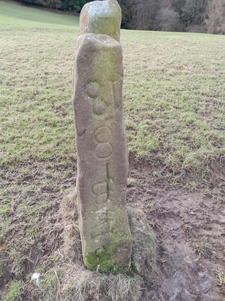
The stone is about four feet high and rectangular, with a square hole cut right through, and the suggestion that it might have been taller, with a piece broken off the top. The inscription is only on one of the narrow sides, and might be the date 1888. Lower down there appears to be a ‘W’. The parish boundary runs along a nearby stream (Bleakley Dike), which may offer a clue as stones were often used as boundary markers, though it’s still not clear why anyone would go to the trouble of cutting the hole. I’d be glad to see photos of anything similar, or suggestions about the function of this one!

Snowmotion

A recent winter view of Youlgreave

Winter has never been the best season for travel, but in the past it must have been far more difficult than today. Not only were roads much worse, but at times the weather seems to have been much colder. Especially in the upland areas of Derbyshire farms and villages were likely to be cut off by snowdrifts, with the constant threat of hunger if people were unable to reach markets. According to the Youlgreave Churchwardens’ records:

This year 1614 began the greatyst snow that ever fell within many memorye. And for heaps or drifts of snow they were very deep; so that passengers both horse and foot, passed over gates and hedges and walls it fell at ten severall times, and the last was the greatest … it continued by daily increasing until 12th day of March …

Snowdrifts at Farley above Matlock in 1947

The freezing winter of 1947, still within living memory, was made worse by the decrepit nature of the country’s infrastructure, worn out by years of war. Heavy snow began in late January and continued well into March. Conditions were primitive in many parts of Derbyshire, as recorded by a Mrs Alsop of Hulland Ward near Ashbourne:

All the local men were called by the council to leave their jobs to help clear the roads. This was all done by hand and shovels – no mechanical diggers in those days. The strong northeast, gale-force winds daily filled the roads. The men worked seven days a week for six weeks or more. … Younger folk trudged to Ashbourne (five miles or more) for bread.

In the Peak conditions were worse and neither roads or railways could be kept open, despite heroic efforts. Around Buxton, Longnor and the Staffordshire side of the Dove valley bombers were used to supply isolated settlements. Thousands of pounds of flour, sugar, jam and tinned goods were dropped by parachute. Tragically, one of the planes crashed on Grindon Moor, killing all eight on board. The weather finally relented in early March, when the landlord and landlady of the Barrel Inn at Bretton could leave the bedroom where they had been trapped for the past five weeks, having been dug out by rescuers.

Source: The Derbyshire and Nottinghamshire Weather Book (1994) Markam, L.