The mystery of Fin Cop

Aerial view of the site of Fin Cop: Curve of ramparts visible top left

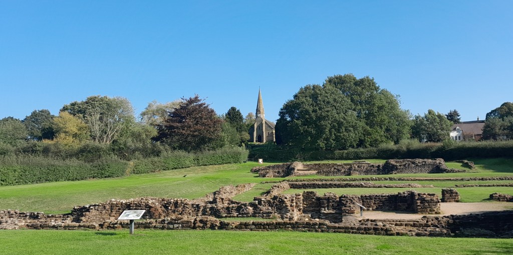
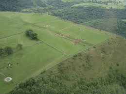
Fin Cop lies on the route of the Portway, about two kilometres north of Ashford in the Water. It is perched on a headland high above the sharp curve in the River Wye in Monsal Dale, and consists of a ditch and incomplete ramparts enclosing an area of about ten acres. Pennyunk Lane, which is believed to be a Celtic name, passes nearby, and is a section of the Portway whose route been somewhat modified by field enclosures. The question is – what was the purpose of the site?

Monsal Dale viaduct with Fin Cop in distance

The OS map marks the site as ‘settlement’, although it is often labelled ‘hillfort’. In fact it may have had several functions, as revealed by the extensive excavations which were carried out in 2009 and 2010 by the local history group supported by Archaeological Research Services. These reveal activity on the site going back to the Mesolithic – the time of hunter gatherers, when local chert was worked into tools. During the Bronze Age there were a number of barrow burials on site, and some kind of enclosure, possibly for corralling livestock. However, the idea of a permanent settlement seems unlikely, at nearly a thousand feet and far above a water source – much more probable that this was a ‘caravanserai’ on the Portway, being about ten miles from the next at Mam Tor, enclosing enough pasture for travellers’ animals to graze on.

Remains of a woman in her 20s, found at Fin Cop in 2010

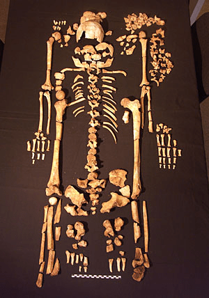
There seems to have been a change, possibly climatic, in the Peak District in the Iron Age, indicated by a reduced population. This theory is supported by the dramatic finds made by the excavation of 2010, which show that about 400 BCE the ramparts were hurriedly raised to a height of about three metres and a ditch dug alongside. In the excavated sections the skeletons of nine women and children were found, whose bodies appear to have been hurriedly thrown into the ditch before the walls were broken down. Given that only a fraction of the site was excavated, this suggests a massacre of possibly over a hundred people, and warfare on a serious scale. We will never know the full story of this fascinating place, but these recent finds give us a taste of one chapter in its long history.

Source: https://www.archaeologicalresearchservices.com/projects/site/index.html

Canal competition

Leawood pump house in steam

For thousands of years goods had to be carried by roads, and a horse and cart could move about a ton of stone or coal. But with industrial growth in the eighteenth century increasing demand for raw materials canals became a feasible mode of transport, a horse-drawn narrowboat could carry 30 tons. From about 1760 the canal network grew quickly, and by 1788 a route was planned from Cromford to Langley Mill, where it would link up with the Erewash Canal and so gain access to the Trent basin. Local entrepreneurs such as Gell at Hopton and lead smelters at Lea and Crich were keen to promote this facility for their minerals, while also benefiting from cheaper coal deliveries.

The aqueduct at Bullbridge

Building the canal with nothing more advanced than shovels and wheelbarrows seems remarkable today, especially as aqueducts were needed to cross the Derwent by the Leawood pump house and over the Amber (above – the railway came later!). In addition, Butterley tunnel, about 3,000 yards long, proved difficult to cut and maintain. The entire route from Cromford to the Butterley tunnel was on a level, so no locks were needed. This saved water, which was always an issue given the original supply was the Bonsall Brook, shared with Arkwright’s mill. The pump house was a later addition, lifting water from the Derwent. The estimate for the canal’s construction was about £42,000, but inevitably the actual cost was nearly twice this when it finally opened in 1794.

The staff of Wheatcroft’s office at Cromford Wharf

The sign in the photo gives a good idea of the goods carried by the canal: not just coal and coke but also salt, pipes and straw. However, by the time this was taken the canal was in decline: from the 1850s the railway was providing a cheaper and faster service. At its peak in the early 1800s the canal carried 300,000 tons per year, and paid shareholders a whopping 20%. But in 1852, as profits declined, the canal was sold to its railway rival – which was already operating the High Peak line from Cromford to Manchester. The tunnel suffered several rock falls, which finally closed the through route in 1900, though local traffic between Hartsay and Cromford continued until 1944. It seems curious that such a substantial, splendid piece of engineering should have such a short life, effectively becoming redundant after only 50 years!

Comfort at the crossroads

Relief showing a Roman imperial messenger arriving at a mansio in a chariot

Roman military dominance depended on its well-known road system, which not only allowed troops to move quickly, but also allowed messengers to ride rapidly with news or orders. To accommodate such travellers a kind of guest house, called ‘mansio’ in Latin, was built at regular intervals on the main roads, offering fresh horses as well as food and lodging.

Just over the Staffordshire boundary, south of Lichfield, are the extensive ruins of a Roman settlement built at the junction of Watling Street (near the line of the A5) and Ryknield Street, which continues to Little Chester and beyond. Both were important Roman roads, and this was first the site of a fort, then a mansio was built, and subsequently a small town grew up around it, known to the Romans as Letocetum.

Excavated ruins at Wall

The remains of the settlement can be visited in the village of Wall, on a gently sloping site only a few hundred metres from the noisy M6 toll road. In the foreground of the picture above are the ruins of a bath house, so that tired wayfarers could have a warm soak after a day in the saddle. It seems strange to imagine public baths in such a remote spot, and it would be interesting to know who was allowed to use them.

Foundations of the mansio

Despite the care with which this site is preserved by English Heritage it is hard to imagine it in its heyday. But an inscription from Aesernia in Italy of the dialogue between an innkeeper and a departing guest gives more flavour, and can be translated as: ‘Innkeeper, let’s settle our account. One measure of wine and bread, one coin; some stew, two coins. Agreed. The girl, eight coins. That, too, is agreed. Fodder for the mule, two coins. That animal can take me to my destination…’.