That elusive cromlech at Riber

The Welsh model

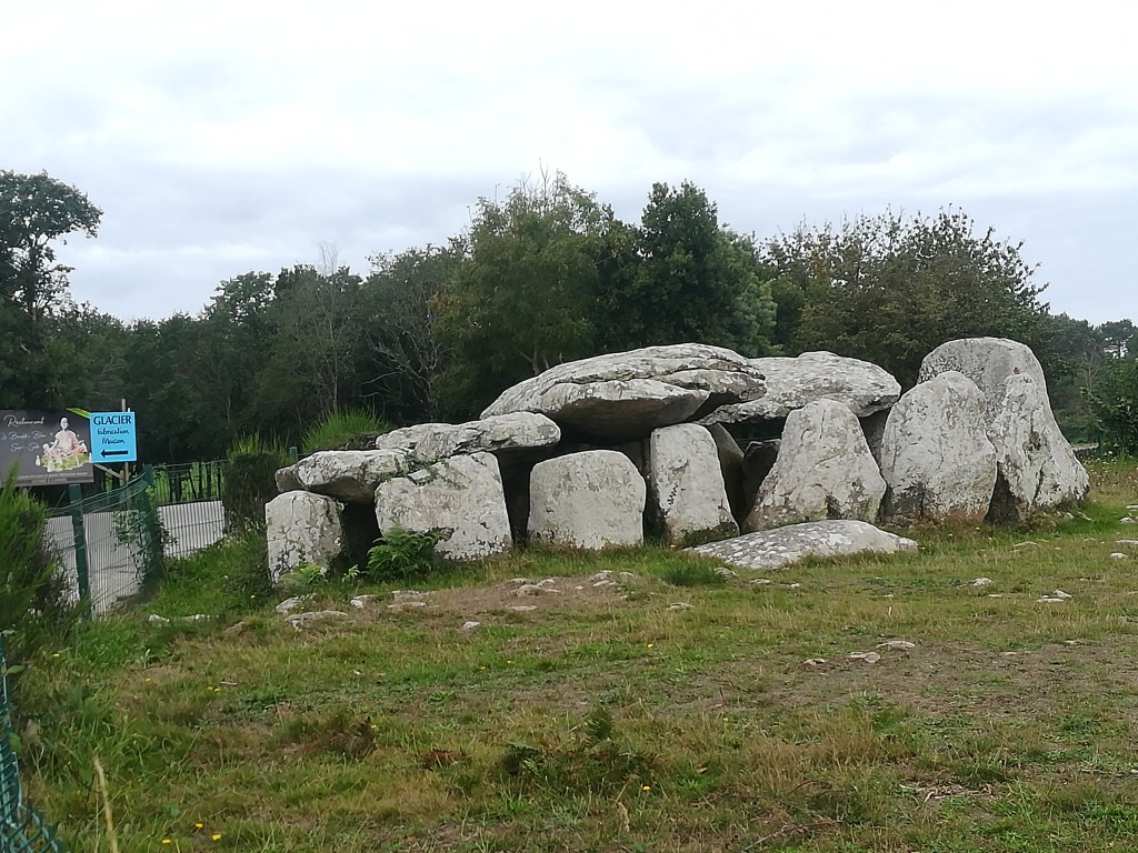
Cromlechs are ancient megalithic structures, thought to pre-date stone circles, so possibly over 6,000 years old. Welsh examples consist of a flat cap stone supported by several upright stones, as in the photo above. They may have been burial sites, but they certainly were not ‘Druidical altars’, as was imagined by early antiquarians. As far as I know there are now none in Derbyshire, but there is some evidence that at least one existed until the early nineteenth century.

Hearthstone Lane, south of Riber

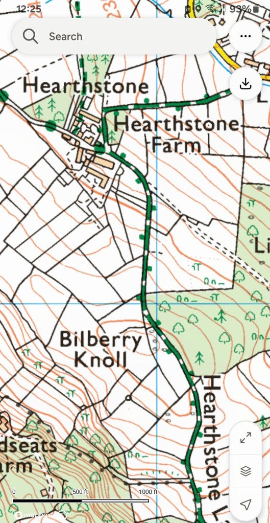
Hearthstone Lane is an ancient route that runs south from Riber to Cromford and beyond. Writing in the Derbyshire Archaeological Journal for 1887, Benjamin Bryan looked at the evidence for a cromlech in this area. There were a surprising number of guide books to the county in the late eighteenth and early nineteenth centuries, and Bray’s Tour of Derbyshire of 1783 mentions a structure on Riber hill consisting of one capstone resting on uprights. A similar monument is mentioned in Pilkington’s View of Derbyshire of 1789, and then Beauties of England and Wales (1803) names this as the Hirst Stones, and describes a hole sunk into the top slab. Frustratingly, none of these writers provides an illustration or an exact position.

Hearthstone Lane above Castletop Farm

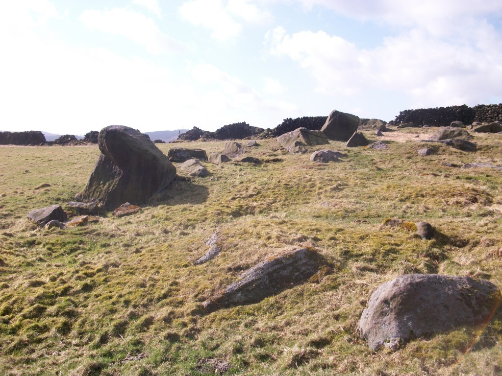
The Matlock Companion of 1835 describes the cromlech as recently broken up, and claims that it had been destroyed by the farmer looking for material for stone walls. In 1866 the editor of the DAJ questioned two old ‘cottagers’ of Riber about the stones, and was told that they both used to play on the monument as children. So there seems little doubt that there had been a cromlech on Riber hill until the early nineteenth century, and it seems likely that the name Hearthstone Lane is a corruption of Hirststone. Several roads in the area are named after prominent stones e.g. Holestone Lane and Cuckoostone Lane. The obvious site of the cromlech is at the top of Bilberry Knoll, the highest point on the lane, providing impressive views in every direction.

The French version, Brittany

This story is a reminder of the chance nature of survival of ancient structures, and how recently and easily they could have been lost. Yet Hearthstone Lane remains as a rewarding historical walk, easily accessible from Cromford station: one of the finest green lanes in the district.

The story of the lane

Hearthstone Lane near Castle Top farm

It is rare to find a historic written description of a Derbyshire road: most literate people in the past took the state of the roads for granted. Therefore it’s especially interesting to have an account of Hearthstone Lane, which runs north from Castle Top farm to Riber, and is today a bridle path. This was written by Alison Uttley, who was brought up at the farm in the late nineteenth century, in her memoir ‘Ambush of Young Days’. She says:

This latter was the old highway, dating from long before any of the roads in the valley. We knew, from family tradition, that the packhorses travelled along it, and that lead from the Roman mines in the hills was once carried down its winding slopes on ponies’ backs. It wandered up to the crest of the hills, cutting through some of our fields, and then it followed the high ridge, between two stone walls, with the land dropping on either side to two valleys. This hill road was grass-covered, and only horses and cows went along it in those days, with sometimes a countryman who was visiting us, the pig-killer, the mole-catcher, the hedger or the thatcher’.

Higher up Hearthstone Lane

Less than a mile from Castle Top farm is the site of an old cottage, easy to miss if you haven’t read Uttley: ‘The Boggart House was sinister, ghostly, and I crept up on tiptoes, although the grass in the lane hid all sound.There were stories about this cottage, which was said to be haunted. I had no fear of the ghost, but of one of the inhabitants. A man and his wife lived there, a good couple, living the most lonely life imaginable … But with them dwelt their son, who had had an accident in the quarries, long ago. He had two noses, it was said, and this is what alarmed me’. Today there are still gooseberry bushes growing in what was their garden, but it seems extraordinary that a family could have lived there, so remote even from a well.

The site of the Boggart House

The Lane is partly a ridgeway, as Uttley appreciated, and the highest point, before it drops down towards Riber, is called Bilberry Knoll. In the field here are a collection of large stones, and it is thought that these are the remains of a megalithic structure which once crowned this hilltop. Given the names of many roads in the vicinity (Holestone, Cuckoostone, etc) it seems likely that this was the Hearthstone (or Heartstone?) after which the Lane was named. Many of these prehistoric sites were destroyed by puritanical landowners who saw them as idolatrous, pagan remains, and this may have been the case here.

Bilberry Knoll