Uphill work in the Dale

Village idyll: Farm and church seen from the wood above Dale Abbey village

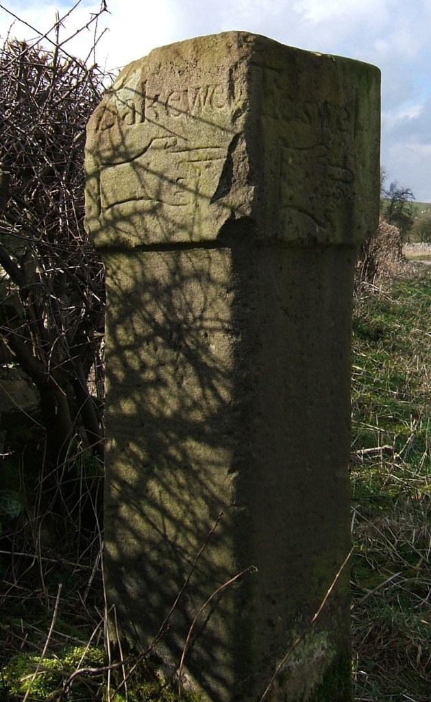
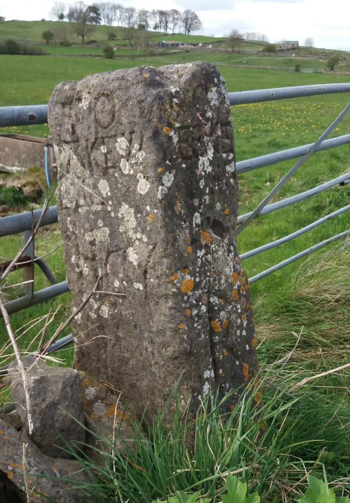
The importance of public rights of way – both footpaths and bridleways – in England is shown by the tremendous effort expended on settling disputes when these routes are challenged. A recent example is at Dale, near Ockbrook in the east of Derbyshire, where the Portway runs past the remains of Dale Abbey and the Hermit’s Cave. The ancient track leaves Hermit’s Wood, goes past the church and into the village, and this point has been the focus of the disagreement.

The bridleway in dispute at Verger’s Farm (A-C on map)

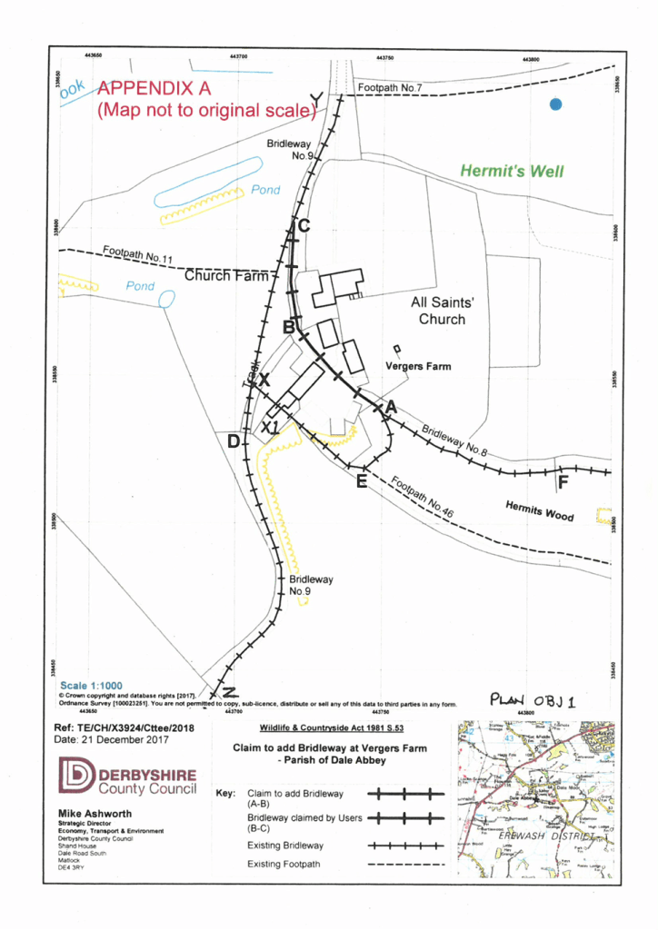
The owners of Verger’s Farm attempted to obstruct use of the route through their farmyard, claiming that an alternative route (E to X on map) should be used, although this involved a stiff climb. This led to an official inquiry opening in 2019, led by an inspector from Defra (Department for Environment, Food and Rural Affairs), who was unable to carry out a site visit until 2021 due to the COVID pandemic. 23 people gave evidence in support of the long-standing existence of the bridleway through the yard, including members of the British Horse Society, a powerful lobby. Against these were 14 objectors, including the family of the farm. A mass of documentary evidence was also presented, including old photos and guidebooks to the district. The inspector, in her final decision in 2023, confirmed the validity of the original route of the bridleway on the strength of the historical evidence, leaving aside the personal statements.

Dale Abby church, semi-detached to the farmhouse next door

This case illustrates the extraordinary passions that a right of way dispute can generate. The bridleway in question is only a few hundred metres long, but caused an argument involving dozens of people, the parish council, the county council (DCC) and Defra, which continued for over four years. Now that the way is officially waymarked, we should recognise their efforts by visiting the village; either walking from the Carpenters’ Arms in Dale village or taking the more ambitious route along field paths from the Royal Oak in Ockbrook.

What’s in a name?

Sign near Holbrook

There are several ‘portways’ in England, such as the route over the Long Mynd in Shropshire, but the Derbyshire Portway seems to be the longest and the best-researched. The route in Derbyshire was first suggested by Cockerton, an historian from Bakewell in the 1930s, who based his idea of a long-distance route on a string of ‘port’ place names such as Alport and Alport Height, which can be linked together in a roughly north-south alignment by existing tracks and paths. These place names are reinforced by references to a ‘Portwaye’ in some medieval documents and two Portway lead mines. Cockerton discussed the origin of the name ‘Portway’ at length, without coming to a definite conclusion. But it seems clear that the word is Anglo-Saxon, and was applied by them to pre-existing, non-Roman routes. Some have suggested an origin linked to ‘porter’, that is someone who carries, but then all roads are for carrying goods. The common Anglo-Saxon word for road was ‘way’, except for the old Roman roads which were ‘streets’. So a ‘portway’ was something special.

The line of the Portway running south from Cratcliffe Rocks, turnpike road to left

A ‘port’ suggests a place of safety and shelter, so I think a portway was a a long-distance route which had ‘ports’ for travellers at intervals of roughly ten miles. These might have been similar to the caravanserai found in the Middle East – defensive sites where wayfarers could sleep, cook and graze their animals overnight. In Derbyshire these are likely to have been on high ground for defence, and a string of probable sites can be identified, from north to south: Mam Tor, Fin Cop, Cratcliff Rocks, Harborough Rocks, Alport Height, Arbour Hill at Dale and Arbour Hill in Wollaton Park. It is noteworthy that three of these have a similar ‘arbour’ component, and a harbour of course is similar to a port.

Harborough Rocks, between Wirksworth and Brassington

Several of these sites, including Mam Tor, Fin Cop and Harborough, have been excavated and evidence of occupation, such as pottery, has been found. But permanent settlement in such high and waterless places seems unlikely, while the designation ‘hill fort’ is too vague. Far more likely that they served to protect tired travellers, and thus answered a question too rarely asked by pre-historians – how did merchants, drovers, priests, soldiers and pilgrims make lengthy journeys before the arrival of inns?

Reading the stone

The stone in the north wall of St Mary’s, Wirksworth

The Wirksworth Stone must be one of the most remarkable examples of sculpture from the Saxon era in England. Discovered in 1820 face down, buried under the church floor, it is thought to have been the lid of a sarcophagus belonging to an early saint, possibly Betti. It dates from about 700 CE, and displays a sophisticated iconography which reveals a strong Eastern influence e.g. the use of the Greek cross with equal arms. Perhaps the most interesting question is who produced this work 1,300 years ago, and was it carried here or made on the spot?

St Mary’s in its oval churchyard

Clearly the present thirteenth-century building (above) was not the first on this site; in fact the name of the local river, Ecclesbourne, suggest a very ancient foundation, probably a minster church for the whole wapentake of Wirksworth. Just as churches were built by travelling stone masons we can assume that sculpture like this was the work of itinerant artists, who would also produce crosses like those at Bradbourne and Eyam. It is claimed that the Wirksworth stone shows the work of two masons, the one responsible for the lower half being more skilled than his (or her) workmate. Although overall the workmanship is somewhat crude, the scenes portrayed cover the whole range of Christian teaching.

The ascent of Christ, in mandala (detail)

The left hand side of the stone has been broken off, so originally there were ten scenes but now only eight are visible. It appears that the stone should be read vertically, top to bottom, rather than left to right like a modern comic strip. So the top left scene shows Christ washing the feet of the disciples, and the one below the Harrowing of Hell, when the crucified Christ is supposed to have descended into Hades. The next pair are clearly the Crucifixion (with four evangelists) paired with the Ascension below. The third scene on the top represents the death of the Virgin, and below this the Annunciation is shown, with Mary seated. The final scene on top is the Presentation of the infant Christ in the temple, and under this the disciples prepare for their preaching mission (note the figure in the boat). Overall, and assuming the missing section showed the Nativity and the Baptism of Christ, the whole panel presents a remarkable statement of fundamental Christian beliefs. The position of Wirksworth on the Derbyshire Portway reinforces the theory that this was the work of travelling craftsmen, bringing the essentials of their religion in pictorial form to the (presumably) illiterate of the Peak.

Harboro’ highlife?

Harboro’ Rocks seen from the High Peak Trail

A couple of miles west of Wirksworth, just above the High Peak Trail, Harboro’ Rocks are a distinctive limestone outcrop rising to 379 metres. The summit offers a splendid view of Carsington Water to the south and the Via Gellia valley to the north, while providing practice pitches for climbers. The Rocks have been the subject of several archaeological digs, the latest reported in the Derbyshire Archaeological Journal (Makepeace 1990 and 2004). According to these, evidence was found of a Late Bronze Age or Early Iron Age settlement: pottery fragments, domestic animal bones, a flint tool and a button. There is also a remarkable cave in which Daniel Defoe found a lead-ming family living in 1720, and which clearly could have been occupied in prehistoric times.

Cave at Harboro’

However, this picture ignores three factors. First, why should anyone settle on such a bleak and elevated spot, with no source of water? The thesis also fails to mention that the Rocks are near the junction of two important ancient routes: The Street, which was engineered by the Romans over an older ridgeway and ran from Wirksworth to Buxton, and the Portway, which headed north from Harboro’ towards Mam Tor and beyond. Finally, the name ‘Harboro” goes back to at least c. 1200 CE and may mean ‘shelter’ or ‘fortified place’, according to Cameron (1959). What must be significant is that this name crops up on two other hilltops along the Portway’s route: Arbour Hill outside Dale and another Arbour Hill in Wollaton.

Burdett’s map of 1762 showing roads west of Wirksworth and position of the Rocks (arrowed)

So my suggestion is that this was not the site of a Bronze Age ‘settlement’, but could have been a fortified campsite for travellers on these two important routes. This would account for the sparse nature of the finds from the excavations – people were travelling light. Similar to the caravanserai found in the Middle East, these campsites seem to have been spaced every six or seven miles along the Portway and would have given the travellers some security for themselves and their animals when they stopped for the night. The next, going southeast, is Alport Height, and to the north, Cratcliffe Rocks.

Inns for travellers were part of the Roman road system, but I doubt whether any were provided in such a backward area as Derbyshire. We can only guess how these campsites were organised; whether locals sold water and provisions to travellers, and how they were maintained. However, there is enough evidence to suggest that these places provided vital protection for long-distance wayfarers until the growth of towns and the development of the modern inn during the medieval period.

Too many ways?

Section of the Portway below Robin Hood’s Stride, aka the Limestone Way

It took 30 years for the first national long-distance trail, the Pennine Way, to be opened. In 1935 an article by Tom Stephenson suggested the creation of the route, inspired by American models such as the Appalachian Trail, but it was not opened until 1965, after years of haggling with landowners such as the water companies. Today its 260-odd miles from Edale to just over the Scottish border are still a formidable challenge, but it has been joined by the development of many more such paths.

The Ecclesbourne Valley Express

The various long-distance paths in Derbyshire have been developed for different reasons. For instance, the relatively new Ecclesbourne Valley Way (11 miles) provides users of the Ecclesbourne Valley Railway with the chance to walk all or part of the route from Duffield to Wirksworth. The Limestone Way (46 miles from Castleton to Rocester) was set up by the local council to promote tourism in the area. The 55-mile Derwent Valley Heritage Way, from Ladybower to the Trent, was created for similar reasons, and to tie in with the World Heritage Site status of the valley. A glance at the Ordnance Survey map will reveal more (green diamonds on the 1:25,000 map), such as the Midshires Way, Peak Pilgrimage or the Cuckoo Way.

On the Portway at Alport Height

Most of the recently created routes link up existing rights of way and waymark the entire track. As such they provide walkers with an alternative to circular walks, although clearly sections can be followed separately. However, only the Derbyshire Portway (55 miles from Sneinton, Nottingham to the Snake Pass) can claim to follow the approximate route of an ancient trackway. The problem with some of these recent routes is a lack of maintenance. It is surprising how quickly signposts disappear, waymarks are hidden by foliage, and even field boundaries are removed. Attempting to walk the Midshires Way recently we found that in the centre of one large field near Palerow Lane the route makes a 90 degree turn, which we missed as there was no marking at all, yet I imagine that few walkers want to be glued to a walking app. Providing proper waymarking, stiles and undergrowth clearance on these routes would be a trivial expense, and would certainly encourage more people to take to the hills.

A walk on the Portway

The Portway as Islington Lane

This walk, which can stand alone or be incorporated into a longer route, gives a taste of one of Derbyshire’s oldest roads, and incorporates many features of historic (or even prehistoric) travel. Starting behind the Miners’ Standard pub above Winster (car parking generally possible opposite) , the track runs north between stone walls. Today the track is labelled as part of the Limestone Way, although Islington Lane, an older name, is a reminder of the miners’ settlement here in the boom days of lead mining. This old road was replaced by the Ashbourne turnpike, now the B5056, which zig zags down the slope to allow carriages an easier incline.

Looking towards Cratcliffe Rocks from the end of Dudwood Lane

After about a mile you cross the Elton road and continue on Dudwood Lane, downhill on what is now a tarmac surface. On the right is the site of the Portaway lead mine, once a substantial producer, which provides clear evidence for the route of the old road. At the bottom of the hill you bypass the cattle grid and start climbing towards Cratcliffe Rocks, with the twin peaks of Robin Hood’s Stride on the left. These rock outcrops must have provided clear landmarks for medieval travellers, and the path runs between them. Evidence has been found at the top of the Rocks of prehistoric habitation, probably to provide shelter for travellers: the summit certainly provides excellent views of the route. Another feature is the medieval hermit’s cave, found in the woods below, which is discussed in a previous blog (Hermits and their Hermitages, 6th August).

Cratcliffe Rocks

Now the track runs beside Robin Hood’s Stride, one of the many Derbyshire features named after this hero. Its striking profile with the rocky pinnacles also gave it the name ‘Mock Beggar’s Hall’. However, the most interesting features of this area are found on the other side of the path, on Harthill Moor, where the stone circle suggests a Neolithic dating. Known as Nine Stone Close, there are actually only four uprights, and there is a suggestion that they may have been re-erected quite recently. Less obvious is an example of cup-and-ring marking on a boulder, a Bronze Age feature not fully understood by archaeologists, but possibly associated with long-distance trackways.

Nine Stone Close

From here the walk can extended on the Limestone Way to Youlgreave, or even to Bakewell via Alport, but the simplest option is to head back towards the Miners’ Standard, where a good lunch and a decent pint can usually be found!

The name of the lane

Road name near Holbrook

Although name signs like this are relatively modern, roads have been named for hundreds of years, and today road names are a useful resource for historians. We do not know what names the Romans actually gave their routes, but after their departure they were called ‘streets’ as in Ryknild Street, which ran from Derby to Chesterfield. Many place names e.g. ‘Stretton’ reflect this. Anglo-Saxons used the noun ‘way’ for their roads, and this survives in many expressions such as ‘highway’ and ‘byway’. The word ‘road’ was not common until the seventeenth century, and may be derived from the verb ‘rode’.

The most obvious type of name gives the destination of the road, hence Chesterfield Road or Brassington Lane. Another refers to some feature found on the road, either natural or man-made, such as Chapel Lane or Cuckoostone Lane. In the case of an ancient route like Hearthstone Lane, running from Cromford to Riber, there is no obvious Stone, raising the question ‘Where was it?’

Hermitage Walk, Nottingham

This sign in The Park in Nottingham is a valuable clue that the ‘Walk’ led to an ancient group of caves (now inaccessible) that contained a rock-cut chapel. Other names refer to the state of the road: Long Lane, Marsh Lane, New Road. In this last case, the name suggests that there is an ‘old road’ that could be investigated.

Many road names refer to natural features using archaic vocabulary. ‘Shaw’ or ‘Carr’ names are common in Derbyshire, and mean a wood on a steep slope, as in Leashaw, Upper Holloway. ‘Sitch’ is Anglo-Saxon for a small stream. ‘Well’ endings as in Bakewell suggest a natural spring.

A few names refer to an individual, either familiarly in ‘Samuel’s Lane’ or more grandly with ‘Via Gellia’, named by Anthony Gell, the road developer, after himself in pseudo-Roman style.

Road sign on the Ridgeway near Heage

But there will always be names that elude discovery, or can only be the subject of wild guesswork. What’s the story behind Lickpenny Lane, for instance, or the Clatterway at Bonsall? Or did Wapentake Lane near Kirk Ireton really lead to the site of the ancient Wapentake?

Crossed out?

Cross in Eyam churchyard

Anyone who has travelled in the more Catholic parts of Europe such as Bavaria or Brittany may have seen the roadside crosses which frequently mark the route. Medieval England would probably have had the same, until various acts of parliament after the Reformation ordered their removal as ‘Popish elements’. The cross was obviously the symbol of Christianity (after 692 CE), and it is thought that they were erected for three reasons: as a base for preaching before churches were built, as a waymark for travellers (particularly pilgrims approaching a shrine), and to mark the boundary of monastic estates. In addition to these religious uses, crosses often marked the site of a weekly market.

Morley Cross, in the churchyard but probably a market cross.

Perhaps because it is relatively remote, Derbyshire is quite rich in the remains of crosses, although the great majority must have been destroyed or lost. Eyam Cross (above) is one of the finest and oldest, although even here a section of the shaft is clearly missing. It is thought to be Saxon work from the ninth century, and its original location is unknown. Not all early crosses had a cross arm: Stapleford Cross (on the Notts/Derby border, below) is simply a shaft with carvings.

Stapleford Cross, which marked the point where the Portway entered Nottinghamshire.

When I first saw the road name ‘Cross Lane’ I assumed it referred to a crossroads, but eventually realised it referred to an actual cross or crosses. One example is at Dethick, where the cross base still survives, half hidden in the undergrowth. But there are others (e.g. at Wessington) which would be worth investigating. Presumably these crosses marked the route to some pilgrimage destination, as would some rare survivals in north Derbyshire such as Wheston.

Wheston Cross, guarded by geese.

Clearly this is a subject which offers plenty of scope for further research by historians, since there are now so few traces of what must have been a significant feature of medieval life. A good starting point is Neville Sharp’s excellent book: Crosses of the Peak District, which includes crosses in parts of Cheshire and Staffordshire.

Conquering the stoop

Guide stoop at top of Crowhill Lane near Bakewell

Nearly fifty of these stone pillars survive in Derbyshire, providing vital clues to the medieval road network. ‘Stoop’ is a Scandinavian word for stone, and they have proved suitably durable, many surviving for over three hundred years. They were erected about 1709 to (belatedly) comply with an Act of 1697 which required direction stones to be put up at road junctions in remote moorland areas, where travellers would be likely to get lost. The majority have inscriptions on four sides, and these should indicate the direction of the nearest market towns. The example above shows a hand pointing to ‘Bakewel’, while the other sides indicate the directions of Tideswell, Buxton and Winster. It is notable that the stone now stands at a T-junction; the fourth route was closed with the opening of the turnpike road on what is now the nearby A6.

Guidestoop above Winster on road to Grangemill

This illustrates one of the values of these stoops: they show the routes that were in use pre-turnpike and pre-maps. The Winster stoop, above, provides another example. It is thought that originally it stood at the end of Bonsall Lane, and indicates Wirksworth, Bonsall and Bakewell. The fourth town marked, however, is Leek, over 15 miles away via Pikehall, but clearly a significant destination at that time. As with some other guide stoops, this one has been used as a gatepost, since most stoops would have become redundant with the arrival of better signposted turnpikes later in the eighteenth century. Nearby, at Shothouse Spring, another stoop (on private land) is no longer on any road or path, although it was clearly erected at a one-time crossroads.

Guidestoop at Alport Height

The Alport stone (showing Derby, Wirksworth and Ashbourne) is another example of a stoop at an apparently remote junction, but clearly thought worth marking in 1709. In fact its position on the Portway suggests that it would have been a more important route at that time. To properly envisage early eighteenth century travel we need to remove most of the dry stone walls and grassy pasture, and go back to a landscape of open scrubby moorland, crossed by the occasional track. In this setting it is easier to imagine the reassurance that the guidestoop would have given the uncertain traveller.

(For a detailed guide to all surviving stoops see ‘The Guide Stoops of Derbyshire’ by Howard Smith)

A walk around Horsley Castle

This 4-5 mile walk includes a medieval castle and a section of the Portway, plus another ancient holloway. Parking is available at various points, but perhaps the simplest is at Coxbench, on the road parallel to the A38 embankment that leads to the kennels, marked MP on the map above. Follow the path up by the kennels, and then take the right-hand path up into the wood. The area to the west has been extensively quarried and the path is effectively following the edge of these quarries. The path then changes direction, turning east, and the ruins of Horsley Castle can be seen on the right.

Like several other Derbyshire castles (Duffield, Pilsbury) little remains of this one, beyond a clump of rough masonry on a mound. It is easier to see the layout in winter, before the trees are in leaf. Little is known of the history of the castle, which is dated to the twelfth century. Clearly most of the stone was robbed when it went into decline. It is nearly a mile from Horsley village, and is presumably sited here to take advantage of the high ground and possibly the proximity of the Portway, which is the route of the footpath, offering good views to the north and west. On the Historic England website it is said that the castle ‘overlooks the strategic Derwent Valley’: clearly impossible given the high ground between here and Duffield!

The castle ruins

From here continue eastwards to Sandy Lane, and then follow this uphill to the settlement of Brackley Gate. The route turns sharp right here, downhill towards Horsley Carr, but note that if you continue on the top road to Quarry Road you will cross the line of Ryknild Street, one of the most important Roman roads in Derbyshire, although now invisible here. The track descends through dense woodland, and when this opens up on the right, take the path that leads you to a tunnel under the A38 road. You now cross, in quick succession, the road to Little Eaton, the Bottle Brook, and the course of the old railway, before turning left on the Alfreton Road for a few hundred yards. Just past the Bell and Harp pub take the road to the right which runs up past houses before climbing more sharply through the wood. This track, in part a holloway, may have been a church path to Duffield church (but also to Duffield bridge).

After half a mile turn right onto the field path running north, and then bear right beyond Daypark, where several tracks lead down to the Holbrook road, here named as Port Way – the only surviving ‘official’ naming of this old route. From here it is less than a mile downhill to Coxbench, where you turn right and then left under the A38 again, back to the starting point.

Church path to Horsley from the Holbrook Portway