The Waters of Life and Death

Burycliffe Troughs, Elton

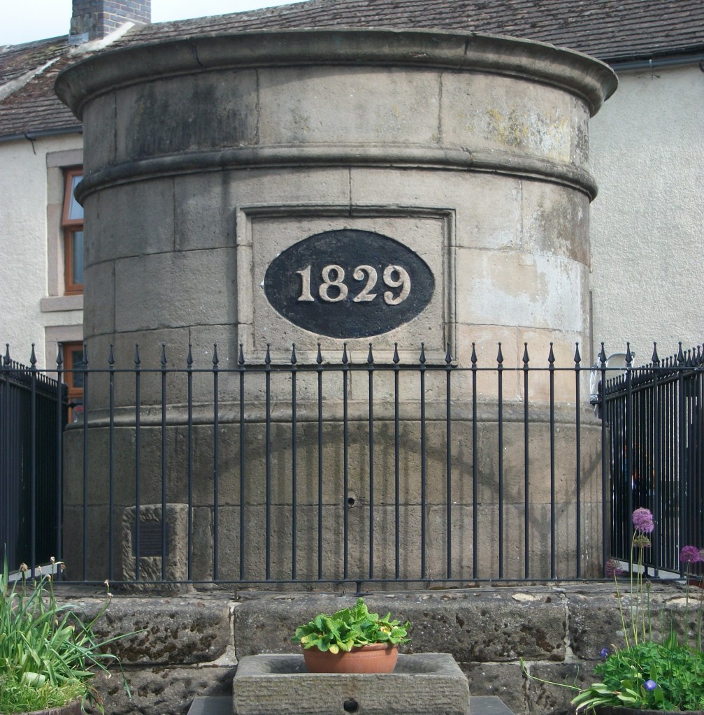
It is easy to forget the significance of a good water supply for both residents and travellers, something which is taken for granted today. But less than a century ago, up to 1940, the village of Elton was dependent for its water on Burycliffe Troughs, half a mile away, water which had to be laboriously carried by householders in buckets. Yet nearby Youlgrave had built its own water system in 1829, as indicated on its central cistern. Though this is not in use today, the village still maintains its independent supply, and provides it much cheaper than Severn Trent!

Youlgrave cistern

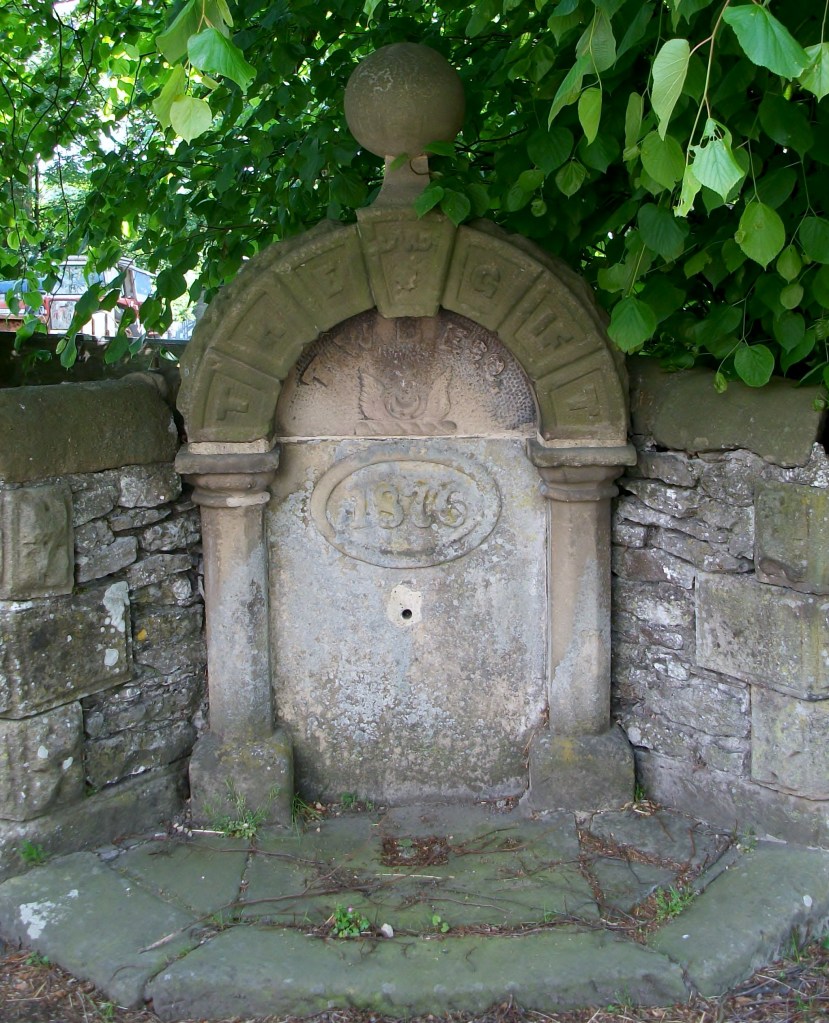
In nineteenth-century villages water was not usually piped to individual houses. Instead villagers collected it from wells scattered around, like this attractive example, also from Youlgrave, titled ‘The Gift’ and dated 1876. Similar examples can be found in many Derbyshire settlements.

The Gift, Youlgrave

Springs and wells had symbolic value in Christianity (and probably also in pagan beliefs). A late example of this is St John’s chapel in St John’s Road, Matlock Bath, a remarkable Arts and Crafts structure of 1895 built over a well, presumably a reference to St John as baptist. The stained glass windows also illustrate ‘The Waters of Life’ and ‘The Waters of Death’.

Well below St John’s chapel.

Many drinking troughs and wells can be found outside villages, as a critical part of the old transport infrastructure. The spring-fed example below, found near the top of the long climb out of Wirksworth and just below the Malt Shovel crossroads, would have provided a welcome drink for horses labouring up the incline, as well as for cattle and other animals being driven to and from market.

Drinking well on Wirksworth – Whatstandwell Road

Sadly, many of these wells have become choked with debris and allowed to dry up. It would be a positive addition to the landscape if they were cleaned and restored – and any passing horses would be very thankful.

A walk on the Portway

The Portway as Islington Lane

This walk, which can stand alone or be incorporated into a longer route, gives a taste of one of Derbyshire’s oldest roads, and incorporates many features of historic (or even prehistoric) travel. Starting behind the Miners’ Standard pub above Winster (car parking generally possible opposite) , the track runs north between stone walls. Today the track is labelled as part of the Limestone Way, although Islington Lane, an older name, is a reminder of the miners’ settlement here in the boom days of lead mining. This old road was replaced by the Ashbourne turnpike, now the B5056, which zig zags down the slope to allow carriages an easier incline.

Looking towards Cratcliffe Rocks from the end of Dudwood Lane

After about a mile you cross the Elton road and continue on Dudwood Lane, downhill on what is now a tarmac surface. On the right is the site of the Portaway lead mine, once a substantial producer, which provides clear evidence for the route of the old road. At the bottom of the hill you bypass the cattle grid and start climbing towards Cratcliffe Rocks, with the twin peaks of Robin Hood’s Stride on the left. These rock outcrops must have provided clear landmarks for medieval travellers, and the path runs between them. Evidence has been found at the top of the Rocks of prehistoric habitation, probably to provide shelter for travellers: the summit certainly provides excellent views of the route. Another feature is the medieval hermit’s cave, found in the woods below, which is discussed in a previous blog (Hermits and their Hermitages, 6th August).

Cratcliffe Rocks

Now the track runs beside Robin Hood’s Stride, one of the many Derbyshire features named after this hero. Its striking profile with the rocky pinnacles also gave it the name ‘Mock Beggar’s Hall’. However, the most interesting features of this area are found on the other side of the path, on Harthill Moor, where the stone circle suggests a Neolithic dating. Known as Nine Stone Close, there are actually only four uprights, and there is a suggestion that they may have been re-erected quite recently. Less obvious is an example of cup-and-ring marking on a boulder, a Bronze Age feature not fully understood by archaeologists, but possibly associated with long-distance trackways.

Nine Stone Close

From here the walk can extended on the Limestone Way to Youlgreave, or even to Bakewell via Alport, but the simplest option is to head back towards the Miners’ Standard, where a good lunch and a decent pint can usually be found!

Wells, springs and troughs

Dressed well, Tissington

Travellers have always needed to drink, and so have their horses and dogs. Yet on the ancient ridgeways, crossing the limestone hills of north Derbyshire, there are few streams or ponds, and so providing drinking places has been critical. Stone troughs fed by springs are found by many old roads, though it is not clear who first installed them. The four horses needed to haul a stagecoach uphill for a mile or two would have needed a long drink by the time they reached the top of the climb.

St Alkmunds Well, Derby

Wells were another source of water, though usually designed just for human use. and more commonly found in villages. Well dressing is a famous Derbyshire custom, and is normally seen as a celebration of a reliable and plentiful water supply – possibly pre-Christian, although now, as the example above shows, co-opted by the Church. Wells have frequently given their name to streets, as with Coldwell Street in Wirksworth or Coldwell End in Youlgrave. Others were sanctified with a saint’s name, such as St Alkmund’s well above, or St Anne’s well in Buxton. It seems likely that the tradition of ‘holy wells’ pre-dates the Reformation in 1539, and in some cases the water from these wells was thought to have a healing value.

Well in Youlgrave ‘The Gift’ 1876

Today it seems shocking how long it took to provide a piped, clean water supply in many Derbyshire villages. Youlgrave was unusual in that it installed its stone reservoir in the centre of the village in 1829 (below), from which local wells such as the one above were supplied. Even today Youlgrave still has its own water supply, independent of Severn Trent. But right up to 1940 nearby Elton people relied on carrying water in buckets from a spring at Burycliffe, half a mile from the village.

Water reservoir, Youlgrave

The names of some old wells can be found on large-scale OS maps, for example Lady Wall Well, north of Baslow on the old route over the moor to Sheffield. Sadly, many of these have become filled with rubbish and are easily overlooked. Cleaning and renovating a local well would be a valuable project for a volunteer neighbourhood group, and help to preserve a link with the not-so-distant past.