Down Ashover way

Tomb of Thomas and Edith Babington in Ashover church

These unusually colorful figures on the Babington tomb at Ashover are a reminder of a long-distance packhorse route that can be traced as far as Wirksworth to the west. Ashover parish used to be much larger, and included Holloway, Lea and Dethick, the home of the Babingtons. St John’s church at Dethick was built as a private chapel for the manor, but Ashover had to be used for burials. Most of the route can be comfortably walked today; leaving Ashover by the track beside the Old Poet’s Corner pub which drops to a bridge over the Amber, and then provides a steep climb up a remarkably complete stone causeway (below).

Onwards and upwards

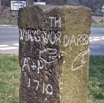
‘Causeys’ like this are found all over Derbyshire and are about two feet wide, thus providing a solid surface for horses’ feet at minimal expense. The track continues to climb towards Ravensnest and then meets Holestone Gate Road at the top. From there it’s road walking to the B6014 and along Lickpenny Lane to the Matlock-Alfreton road. At this point a guidestoop can be seen on the verge, dated 1710, marked A+P for Ashover Parish. Wirksworth is one of the directions shown, via Dethick Lane (NB the stoop has been moved from its original position, but not significantly). Dethick Lane is partly a holloway, Cross Lane marks the site of an old cross (only the base remains), and beyond the church the path leads down to a crossing of the Lea Brook on stepping stones, then uphill to cross Hearthstone Lane and down to Cromford Station and bridge.

Looking down the steps at Eastwood Grange

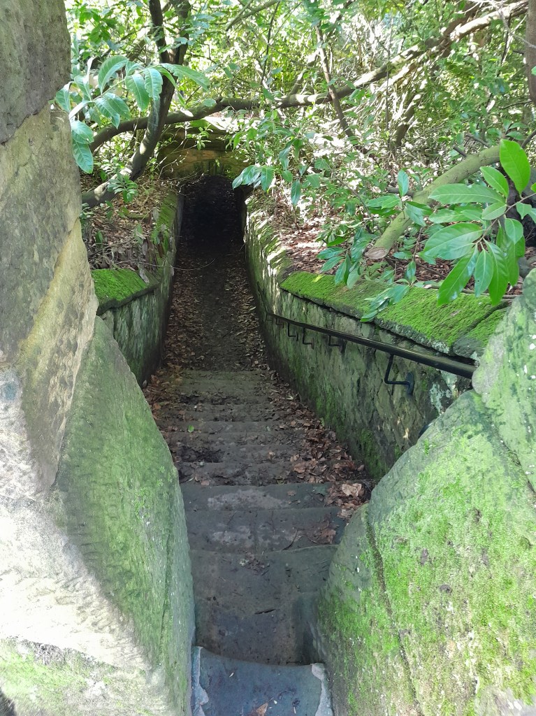
Where did the route go to the east from Ashover? One likely possibility is the footpath which starts beside the Black Swan and runs up through the grounds of Eastwood Grange, today a school but which must have been built in Victorian times as a substantial private villa. The route (even if no longer used by packhorses) was clearly significant enough to be given a well-engineered stone-lined route through the gardens of the Grange, as can be seen above. Beyond this the path continues steeply up to the summit of Farhill, a popular viewpoint at 299 metres, from where Hardwick Hall, Chesterfield and Sheffield can be seen.

Wayside worship

Altar to the Quadruviae in Germany

For at least two thousand years European roads were marked by shrines and sanctuaries, giving travelers the chance to rest, make offerings and pray for a safe journey. The Romans dedicated some to well-known gods such as Hercules and Mars, but they also had divinities specific to travel: Biviae at the meeting place of two roads, Triviae for three and Quadruviae for four, as in the example above, found in Germany. These junction divinities were all female, and give us some insight into the mindset of the ancient world. Even in medieval times in England a crossroads was seen as a place of significance, suitable for the burial of suicides (finally abolished by act of parliament in 1832).

Roadside scene (detail). Eighteenth century

The painting above, in the Thyssen Museum in Madrid, provides a rare glimpse of what may have been a common sight in the pre-industrial world: at a small stone shrine one man is on his knees, while another, on horseback, makes an offering. Yet in Catholic areas of Europe this tradition continued into the twentieth century, as described by DH Lawrence in his essay ‘The Crucifix across the Mountains’. In 1912 Lawrence and Frieda made an epic journey, mainly on foot, from Bavaria to Lake Garda in Italy. Lawrence was struck by the carved wooden crucifixes they found by the roadside:

Coming along the clear, open roads that lead to the mountains, one scarcely notices the crucifixes and the shrines … But gradually, one after another looming shadowily under their hoods, the crucifixes seem to create a new atmosphere over the whole of the countryside, a darkness, a weight in the air …

Wheston Cross near Tideswell

Derbyshire roads had their share of shrines, although little is known of pre-Christian examples. However, it is difficult to judge which of the surviving crosses were boundary markers and which were wayside crosses. At the reformation in the sixteenth century the crosses, usually dedicated to a saint, were generally destroyed as being Popish. However, a few survived, such as the cross at Wheston, which has the Madonna and Child on one face and the Crucifixion on the other. It is about 11 feet tall, but part of the shaft is more recent. Such crosses must have helped travelers navigate generally, but may also have been used to point the way to pilgrimage churches. One clue to the previous existence of a cross is the name ‘Cross Lane’, found in various locations in the county, such as just above Dethick. The topic is fully explored in Neville Sharpe’s ‘Crosses of the Peak District’.

Crossed out?

Cross in Eyam churchyard

Anyone who has travelled in the more Catholic parts of Europe such as Bavaria or Brittany may have seen the roadside crosses which frequently mark the route. Medieval England would probably have had the same, until various acts of parliament after the Reformation ordered their removal as ‘Popish elements’. The cross was obviously the symbol of Christianity (after 692 CE), and it is thought that they were erected for three reasons: as a base for preaching before churches were built, as a waymark for travellers (particularly pilgrims approaching a shrine), and to mark the boundary of monastic estates. In addition to these religious uses, crosses often marked the site of a weekly market.

Morley Cross, in the churchyard but probably a market cross.

Perhaps because it is relatively remote, Derbyshire is quite rich in the remains of crosses, although the great majority must have been destroyed or lost. Eyam Cross (above) is one of the finest and oldest, although even here a section of the shaft is clearly missing. It is thought to be Saxon work from the ninth century, and its original location is unknown. Not all early crosses had a cross arm: Stapleford Cross (on the Notts/Derby border, below) is simply a shaft with carvings.

Stapleford Cross, which marked the point where the Portway entered Nottinghamshire.

When I first saw the road name ‘Cross Lane’ I assumed it referred to a crossroads, but eventually realised it referred to an actual cross or crosses. One example is at Dethick, where the cross base still survives, half hidden in the undergrowth. But there are others (e.g. at Wessington) which would be worth investigating. Presumably these crosses marked the route to some pilgrimage destination, as would some rare survivals in north Derbyshire such as Wheston.

Wheston Cross, guarded by geese.

Clearly this is a subject which offers plenty of scope for further research by historians, since there are now so few traces of what must have been a significant feature of medieval life. A good starting point is Neville Sharp’s excellent book: Crosses of the Peak District, which includes crosses in parts of Cheshire and Staffordshire.