Brailsford byways

Brailsford church, midway between villages

Despite being close to the busy A52 Derby to Ashbourne road, Brailsford church, All Saints, is unusually isolated, west of the village, and nearer to Ednaston. But the map shows it at the centre of no less than six footpaths and bridle ways, one of which is now waymarked as ‘Centenary Way’ but known locally as the Coffin Path, linking the church to both villages.

The south side of the church

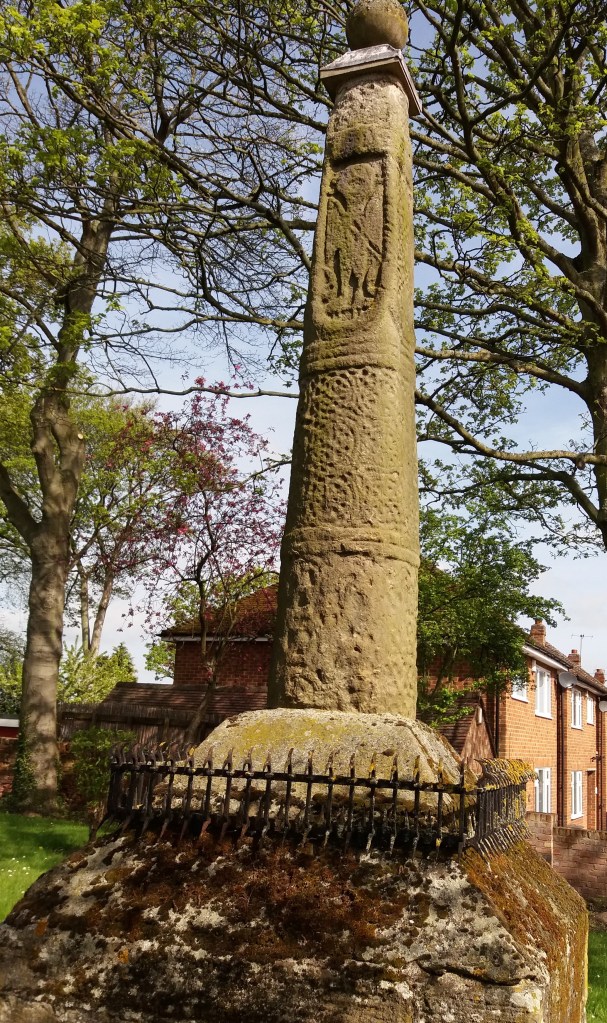
All Saints, which has some Norman work, is set in a well-wooded graveyard; near the south porch is an impressive yew tree, which may be nearly as old as the church itself. But the oldest thing here must be the stump of a cross, dug up after (presumably) being hidden at the Reformation (see my previous post on crosses). This fragment has been dated to the tenth century, though such dating is not an exact science.

Brailsford Cross

The cross, the yew and the church itself all suggest that this has been a sacred site for over a thousand years, while the pattern of footpaths shows that it has been used for burials by both Ednaston and Brailsford villagers. Today, it may be hard to understand the importance once attached to burial in holy ground, but belief in resurrection in the Medieval period was strong. The wealthy were remembered by marble plaques inside the church, while humbler folk at least had the comfort of the churchyard.

Surprising Bradbourne

All Saints churchyard with cross

Halfway between Brassington and Tissington is the small village of Bradbourne, with a population of just over a hundred. Yet the substantial church was once part of a priory, and was the centre of a network of local chapelries. The church tower, complete with elaborately carved doorway, is Romanesque. while in the churchyard is a rare Saxon cross from about 800, showing a crucifixion scene. Why would such a small settlement have such rich monuments?

Crosses of this date are quite rare in Derbyshire: Bakewell and Eyam have good examples. Clearly older than the church itself, they may have signalled the conversion of the area to Christianity, and formed a base for preaching before the church was built. It is possible that such crosses were more common, but many may have been destroyed during iconoclastic periods such as the Reformation. Wirksworth, only a few miles away, would probably be the local minster church.

Doorway to tower with a variety of carved creatures

There is little sign that Bradbourne was ever on a major route. According to the parish council website, the north eastern parish boundary was the course of the Roman road from Little Chester to Buxton, but no source is given for this claim. However, this is now good walking country; the Limestone Way runs about a mile to the north, and to the south Haven Hill (partly access land) offers a convenient circular walk.

Crossed out?

Cross in Eyam churchyard

Anyone who has travelled in the more Catholic parts of Europe such as Bavaria or Brittany may have seen the roadside crosses which frequently mark the route. Medieval England would probably have had the same, until various acts of parliament after the Reformation ordered their removal as ‘Popish elements’. The cross was obviously the symbol of Christianity (after 692 CE), and it is thought that they were erected for three reasons: as a base for preaching before churches were built, as a waymark for travellers (particularly pilgrims approaching a shrine), and to mark the boundary of monastic estates. In addition to these religious uses, crosses often marked the site of a weekly market.

Morley Cross, in the churchyard but probably a market cross.

Perhaps because it is relatively remote, Derbyshire is quite rich in the remains of crosses, although the great majority must have been destroyed or lost. Eyam Cross (above) is one of the finest and oldest, although even here a section of the shaft is clearly missing. It is thought to be Saxon work from the ninth century, and its original location is unknown. Not all early crosses had a cross arm: Stapleford Cross (on the Notts/Derby border, below) is simply a shaft with carvings.

Stapleford Cross, which marked the point where the Portway entered Nottinghamshire.

When I first saw the road name ‘Cross Lane’ I assumed it referred to a crossroads, but eventually realised it referred to an actual cross or crosses. One example is at Dethick, where the cross base still survives, half hidden in the undergrowth. But there are others (e.g. at Wessington) which would be worth investigating. Presumably these crosses marked the route to some pilgrimage destination, as would some rare survivals in north Derbyshire such as Wheston.

Wheston Cross, guarded by geese.

Clearly this is a subject which offers plenty of scope for further research by historians, since there are now so few traces of what must have been a significant feature of medieval life. A good starting point is Neville Sharp’s excellent book: Crosses of the Peak District, which includes crosses in parts of Cheshire and Staffordshire.