This stone, partly broken, can be found lurking in the hedge of the minor road that links Fritchley with Wingfield. Although partly broken, one side still reads ‘Winfiel(d)’ and the other ‘Crich’. Easily mistaken for a milestone, this is actually a boundary stone marking the limits of these two parishes, marked BS on Ordnance Survey maps. The boundary here can still be followed on public footpaths, southwards to a footbridge over the River Amber and Sawmills, northwards (briefly) to Park Head. The OS maps mark the boundaries with black dots, though they can be difficult to see.
A custom revived
The parish system of local government is thought to have been established in Saxon times, although individual parishes were originally much larger. In the past, parishes were the only kind of local authority that affected most people’s lives, being responsible, for example, for road maintenance. Therefore the limits of the parish were important, and in a largely pre-literate society this knowledge had to be handed down orally, hence the annual perambulation known as ‘Beating the Bounds’. This involved the priest, various landowners and some unfortunate young lads, whose fate was to be beaten at critical points so they would remember them. Who knows whether this beating was symbolic or real?
Another stone in North Derbyshire
Rivers and streams were often used as boundaries, since they were unlikely to move very much, but as they were not always available other marks, such as large trees, might be used, and clearly boundary stones were sometimes also needed. Where the line of a road (or footpath) is a boundary it suggests that the road is very ancient and important, such as sections of the old Roman road (The Street) running north from Pikehall, which was in use for at least 1,500 years. Today the custom of bounds beating is obviously redundant, but in places it has been revived as an enjoyable excuse for a group walk, as in the Macclesfield example above. More locally, a WEA group from Crich re-enacted the ceremony in 1984, and produced a very helpful written account of their route around the 14 miles of the parish boundary. See: https://www.crichparish.co.uk/PDF/beatingbounds.pdf
‘But it’s real England – the hard pith of England’, Lawrence wrote to Rolf Gardiner in 1926. He was referring to the hill country of the Derbyshire and Nottinghamshire border, near his birthplace at Eastwood, going on to offer to ‘walk it with you one day’. Various walks described in Sons and Lovers explore this area. One of the most arduous took place on an Easter Monday, when, aged nineteen, Paul (i.e. Lawrence) organised a walking party of family and friends, including his sister and Miriam.
We also have his sister Ada’s description of the real walk, which took place in 1905, and which she recorded in her Early Life of D.H. Lawrence. Parts of her account show an interesting discrepancy with his fictional version. For instance, Sons and Lovers portrays the young people as feeling rather nervous when they enter Alfreton Church, but according to Ada they held a mock service:
He said we must sing a hymn or two, and threatened awful punishments if anyone laughed or treated the occasion lightly. I played the organ and we sang. After the boys had explored the belfry we set off for Wingfield.
It is not difficult to follow their route today, starting from Alfreton station. It is a modern, utilitarian structure, but is on a busy main line and offers direct trains to Liverpool, Manchester, Sheffield, Norwich and Nottingham. The service between here and Paul’s starting point, Langley Mill (fictionally Sethley Bridge), still runs today.
It was great excitement to Miriam to catch a train at Sethley Bridge, amid all the bustle of the Bank Holiday crowd. They left the train at Alfreton.
The station is at the eastern edge of Alfreton, and it’s quite a long trek up Mansfield Road to the High Street. To the north of this route was the location of Alfreton Colliery, closed in 1967, and short terraces of what must have been miners’ houses lead downhill towards its site. On one corner is the Station Hotel, a bulky redbrick structure which was probably serving miners as Paul’s party passed by.
Paul was interested in the street and in the colliers with their dogs. Here was a new race of miners.
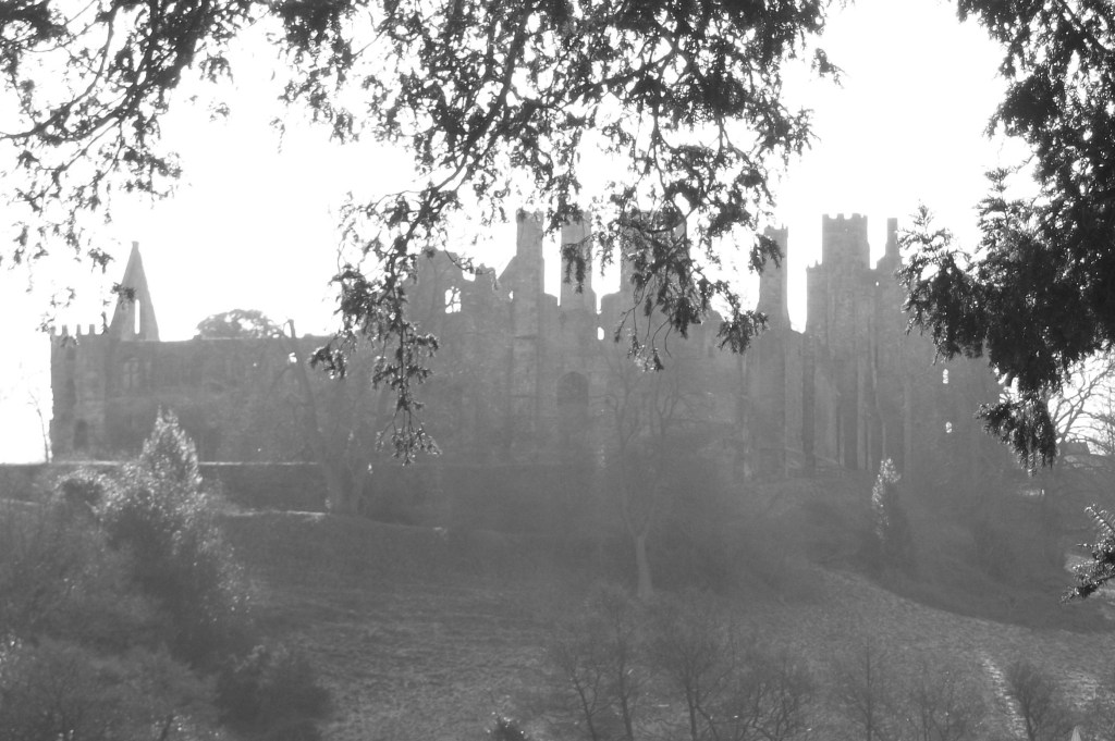
Wingfield Manor in a romantic mist
There are no details given of how the party went from here to Wingfield Manor, but the obvious route is to take the stone-flagged alley to the corner of the churchyard and then follow the green lane westwards. By the church the view of the hills, with Crich church spire and Crich Stand so clearly visible, shows that Paul really had no need of a map.
The green lane dwindles to a field path, but the route is clear, and after about a mile’s walk through deserted pasture you come out at the hamlet of Oakerthorpe, nearly opposite the impressive white bulk of the Peacock, an old coaching inn. This was the junction of two turnpike roads, one of which, running north, followed Ryknild Street, the old Roman road from Derby to Chesterfield.
The footpath continues heading west, beside the new houses, and then crosses the Midland Mainline on a wide wooden bridge. There’s a splendid view of the Amber valley from here, with South Wingfield church in the foreground and Wingfield Manor in the hazy distance. It’s a short walk down to the narrow river and then into the churchyard, frequently flooded and even more remote from the settlement than the one at Alfreton. Why, in the thirteenth century, was this damp spot chosen for a church, when the bulk of the village was on higher ground and nearly a mile distant?
South Wingfield is a village without a centre; everything, including the Manor, seems to be on the periphery. Wingfield Manor was apparently the focus of Paul’s expedition, with over a page devoted to a description of the ruins:
It was past midday when they climbed the steep path to the manor. All things shone softly in the sun, which was wonderfully warm and enlivening. … The young folk were in raptures. They went in trepidation, almost afraid that the delight of exploring this ruin might be denied them.
They were lucky not to make this visit today, since public access to Wingfield Manor has for years been limited to a few hours each month, for pre-booked parties only. This extraordinary restriction on access by the custodian, English Heritage, to one of the most important monuments in the East Midlands, which had been open to the public for over a century, has never been properly explained. Built by Ralph Cromwell in the 1440s, and used by the Earl of Shrewsbury to imprison Mary Queen of Scots in the sixteenth century, it is both highly picturesque and historically important. Despite this, it is now effectively out of bounds to the public, who will be denied the pleasures felt by Paul and Miriam:
Round the broken top of the tower the ivy bushed out, old and handsome. Also, there were a few chill gillivers, in pale cold bud. … The tower seemed to rock in the wind. They looked over miles and miles of wooded country, and country with gleams of pasture.
Round the back
Fortunately there is a public footpath which runs around the back of the Manor and allows you to get fairly close to the buildings. It was here that the initial physical contact between Paul and Miriam is described:
She held her fingers very still among the strings of the bag, his fingers touching; and the place was golden as a vision.
The path comes out on a narrow road, Park Lane, which I followed uphill to Park Head. Paul’s exact route into Crich is uncertain, but there are clear field paths from here. Unsurprisingly, his party was now ‘straggling’, like the village itself:
At last they came into the straggling grey village of Crich. Beyond the village was the famous Crich Stand that Paul could see from the garden at home.
But this was not the same Stand that we see today, which was built as a war memorial to the Sherwood Foresters in 1923. At the turn of the century a shorter tower stood on the site, which had been built in the mid-nineteenth century but had become derelict by the time of Paul’s visit. However, at a height of nearly 1,000 feet, and on the edge of the Pennines, the view was and is magnificent: ‘They saw the hills of Derbyshire fall into the monotony of the Midlands that swept away south.’
The view of the Stand from Paul’s house at Eastwood has been mentioned before in the novel, and to some extent it represents for him the wider world, outside the mundane surroundings of his birthplace, in the same way that the Manor represents history and pageantry. In a perhaps related way, the name Crich, which suggested the literal horizon of Lawrence’s view throughout boyhood, was later used by him for the mine-owning family in Women in Love. From here the walk went downhill, metaphorically as well as literally:
They went on, miles and miles, to Whatstandwell. All the food was eaten, everybody was hungry, and there was very little money to get home with.
Ada Lawrence provided more detail of this section of the walk in her memoir. Apparently they continued on to Holloway, and then back to Whatstandwell, possibly by the canal tow path. On the first part of this route the view over the Derwent valley is spectacular, stretching from the towers of Riber Castle in the north to Alderwasley Hall and Alport Height further south. Arriving in Whatstandwell:
They managed to procure a loaf and a currant loaf, which they hacked into pieces with shut-knives, and ate sitting on the wall near the bridge, watching the bright Derwent rushing by, and the brakes from Matlock pulling up at the inn.
The Derwent river, the wall and the inn (now The Family Tree) are all still there, but it would now be difficult to buy any bread in the village as the last shop closed many years ago. The ‘brakes’ would have been horse-drawn carriages used for short outings, since this village was a recognised holiday spot, offering tea gardens with views of the valley.
The final leg of their walk was to Ambergate Station to get the train home, about two miles from Whatstandwell Bridge. At that time it would have been possible to walk along the road, now the busy A6, but today the tow path of the Cromford Canal offers a more peaceful alternative. The station at Ambergate would then have been much busier than the present unmanned halt; a hundred years ago it was one of the very few triangular stations in the country, and offered services to Nottingham, Derby, Sheffield and Manchester.
Paul was now pale with weariness. … Miriam understood, and kept close to him, and he left himself in her hands.
Their itinerary gives an interesting insight into levels of fitness then. The distance from Alfreton to Ambergate via Holloway is at least twelve miles, depending on route, but in addition they would all have had to walk to the station at Langley Mill (about two miles each way), and Miriam and her brother Geoffrey perhaps two more miles to their farm. So the minimum length of the walk was about sixteen miles – not exceptional, but quite impressive.
The Derwent Hotel at Whatstandwell Bridge, now The Family Tree
Whatstandwell must be one of the more bizarre place names in Derbyshire, mispelt on some old maps as ‘Hotstandwell’. In fact it commemorates Walter (Wat) Stonewell, who lived near the bridge, built by John de Stepul in 1391, according to records from Darley Abbey. The bridge was rebuilt in the late eighteenth century, and widened more recently. Although the bridge today carries the north/south A6, it was originally constructed for east/west traffic, moving between Crich, Wirksworth and beyond. Building a bridge here would have been a major expense, and John may have paid for it as an act of charity. Clearly the original bridge must have been narrower and more basic, but such an early date suggests the importance of this river crossing, which would have been a ford previously.
Causey between Whatstandwell and Crich
On the east side of the bridge there are two main routes which converge on the river crossing. The main road (B5035) climbs steeply over the canal and up towards Crich. This was part of the Nottingham to Newhaven turnpike of 1759, which eased the gradient of the climb up to Crich by adding a loop above Chasecliff farm. The original track can still be followed, climbing directly up the hillside, with a stone causey still visible in places, as shown above. The other route has been obscured by the building of the canal and railway, but can still be followed by taking the Holloway road towards Robin Hood and then taking the first path on the right. This leads up through Duke’s Quarry, named after the owner, the Duke of Devonshire, and this track would have carried stone to either the trains or barges. However, the path is much older than either types of transport, and continues up through pleasant, semi-wooded fields to Wakebridge.
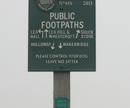
The route to Shuckstone Cross
After crossing the Crich/Holloway road (currently closed) the track now runs to the left of Wakebridge Farm and climbs steadily to high ground at about 270 metres. As can be seen on the map, Shuckstone Cross in Shuckstone Field is the meeting point of at least five paths. Only the stone cross base now remains, but this is (possibly) marked with the destinations of the routes. The track from the bridge now continues northwards to meet the road, but can be walked to High Oredish and beyond that, Ashover. Although in practice it’s impossible to date routes such as these, the section from Wakebridge up to Shuckstone is exactly on the boundary of two of the historic Derbyshire hundreds, which suggest that it may have existed before the county was divided in the Saxon period.
The stone I found in my local woods recently is typical of the thousand-odd millstones scattered around the Peak District – and are used as a symbol for the National Park. Clearly fashioned from the gritstone of the ‘edge’ behind me, this example raises some intriguing questions: who made it? why was it abandoned? how was it transported?
On Stanage Edge
Both wind and water mills used pairs of millstones to grind grain between them; the stones were about 1.8 metres wide and each weighed nearly 2.5 tons. Millstone grit from North Derbyshire was considered the best material for these, and in the late seventeenth century a pair would cost about nine or ten pounds, reflecting the skill and effort required to make them. Most production seems to have been small-scale; perhaps providing winter work for farmers, and may have been concentrated in the Hathersage area and along the ‘edges’, but there is also documentary evidence of manufacture at Alderwasley, Crich and Holloway. However, in the eighteenth century, with rising standards of living, demand for white flour increased and milling this needed finer chert millstones. Quite suddenly, the traditional stones were unwanted, and this may account for the numbers that were abandoned – although some may have cracked or had other defects.
Keep them rolling …
One minor mystery is how such heavy, valuable objects were transported, given that they were sold all over England and exported to the Continent. The sites of the quarries were often remote from the nearest road, so they may have been rolled in pairs, fitted with a wooden axle, until they could be craned onto a cart. In 1676 a miller at North Elmshall paid seven shillings and sixpence for carrying his new stones 22 miles. At Baslow there were complaints about loads of millstones weakening the bridge over the Derwent, and fines for offenders, which suggests fairly heavy traffic. As with lead, Bawtry was the main inland port for shipping millstones, both for export and to other English regions. But perhaps the biggest mystery is how the semi-amateur masons were able to produce such precisely cut stones with the crudest of tools.
Road building in Derbyshire can be fraught, especially on steep-sided valleys. At times roads become too expensive to maintain, as happened with the road below Mam Tor, which was abandoned in the 1970s after frequent landslips due to the unstable geology. Following the exceptionally wet autumn and winter of 2023-4 several routes are currently closed, such as Beeley Lane. The village of Holloway has been badly affected; first the Cromford to Lea Bridge road was closed for over a year after flooding from the River Derwent in 2019, and then shortly after that was re-opened the Holloway to Crich road was closed due to a landslip undermining the pavement. This has now been blocked for over a year, and the County Council is not planning to start repair work until mid-2025.
This stretch of road was originally part of the Cromford Bridge and Langley Mill turnpike of 1766, built before the A6 provided a smoother, lower route. The house on the left, above, was one of the toll collectors’ cottages. At that time this would have been a narrow lane with just enough width for two carts or carriages to squeeze past. A report in the Derby Mercury in 1897 of a public meeting in Crich shows that the problems with this road are longstanding:
Mr Shaw brought forward an important matter, that of repairing the turnpike road leading from Bull Bridge to Holloway, stating that he thought, with many others, that the road ought to be taken over by the Derbyshire County Council. It was, however, clearly proved by Mr Dawes and other gentlemen that the County Council had been repeatedly requested to take over this road, but would not do so, their excuse being that there was insufficient through traffic.
Walkers and cyclists only
It appears that the road was widened, surfaced and the pavement built in the 1930s, by which time the DCC had been obliged to take over maintenance. ‘Shaw’ in place names can mean a wood on a steep bank, and this accurately describes the route on both sides of Wakebridge, and explains why it is so difficult to maintain.
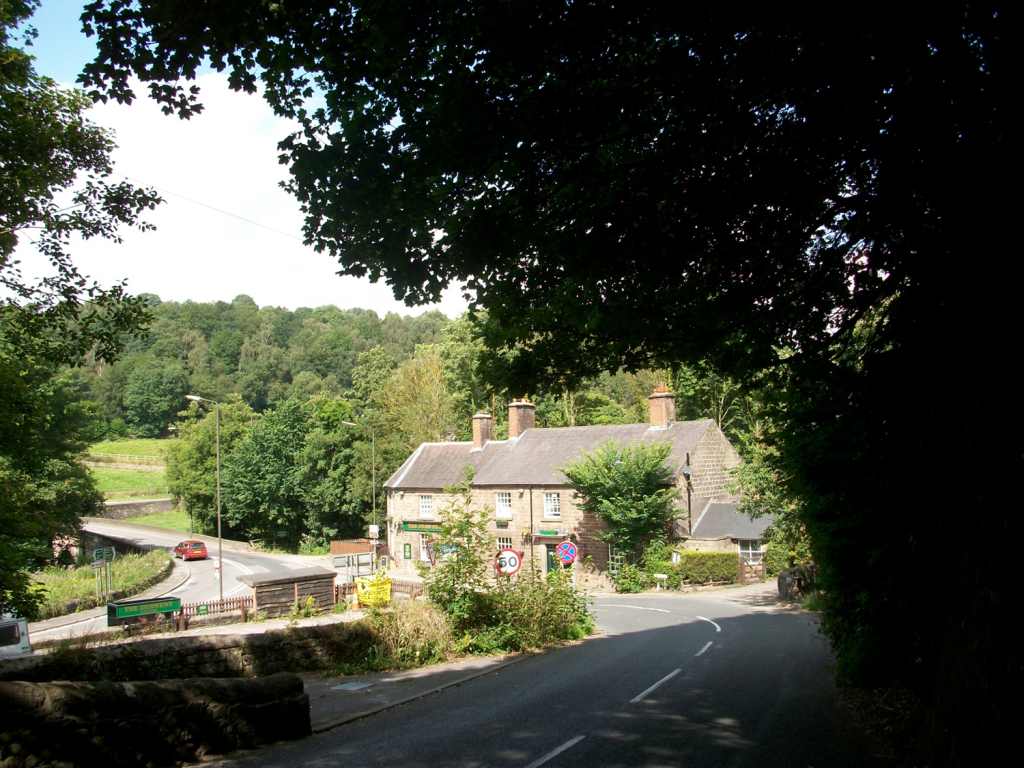
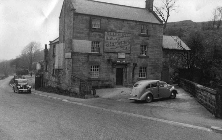
The good old days – the Cliff pub
The situation is not just inconvenient for Crich and Holloway people. Several businesses are struggling with the lack of passing trade: Maycock’s Butchers and the Chase Cafe at the Holloway end, and the Cliff pub (above) at the edge of Crich. It seems that over 250 years after the turnpike was opened, a much wealthier society is unable to keep it open.
The Roman legions are supposed to have been capable of marching 20 miles per day. Even allowing for the Roman mile being slightly shorter than the modern mile, reducing the length to about 18 miles, this still seems very ambitious. It assumes they were walking on fairly well-surfaced roads rather than rough ground, but they must have been burdened by heavy equipment like shields. I imagine that this distance might have been possible in brief spurts, but for longer journeys something like 15 miles seems more realistic. However, the question of how far people could and did walk in a day is interesting, and can have surprising answers.
Looking down into Edale from HollinsCross
There are many nineteenth-century examples of people walking remarkable distances to their work, especially in rural areas such as Derbyshire. It is easy to forget the complete lack of public transport in the days before bicycles became a practical solution. The 1851 Census records about 50 mill hands living at Castleton who worked at the cotton mill in Edale – their daily commute was about 3 miles each way but involved a climb of about 800 feet over Hollins Cross – in all weathers! Thomas Hardy’s novel Jude the Obscure describes Jude’s ten-mile walk to work as a stonemason; a figure which seems fantastic now but which must have been less remarkable when published in 1895. Even the walk to school could be arduous for children from outlying farms: Alison Uttley recalls her daily trudge from Castletop Farm near Cromford to Lea School, via Bow Wood – about a mile and a half each way. At the beginning of the twentieth century DH Lawrence, when a schoolboy in Nottingham, had to walk over two miles from his home in Eastwood to Kimberley station to catch a train into the town. As fictionalised in Sons and Lovers:
‘Mrs Morel was rather anxious about his health. But she herself had had to put up with so much that she expected her children to take the same odds’.
The romantic ruins of Wingfield
Lawrence also provides a good illustration of the popularity of hiking in the early twentieth century among the more radical working classes. For the first time, people had sufficient energy to go walking in their free time – something that would have been unthinkable for a labourer a hundred years earlier. In Sons and Lovers he describes a walk taken by a group of young folk, all from the Congregational Church in Eastwood, from Alfreton station via Crich to Ambergate station. Here he fictionalises an actual walk he led at Easter 1905, in which they visited Alfreton church, Wingfield Manor and Crich Stand (clearly not the present tower). On arrival at Whatstandwell:
‘They managed to procure a loaf and a currant loaf, which they hacked into pieces with shut-knives, and ate sitting on the wall near the bridge, watching the bright Derwent rushing by, and the brakes from Matlock pulling up at the inn’.
Given that all the walkers had to walk to and from the station at the start and end of the walk, the minimum distance they would have walked is about sixteen miles – a distance that would give many modern (and better-shod) hikers a real challenge!
Sources:
Robert Frost ‘Stopping by woods on a snowy evening’
Fletcher, A.J. (1971) ‘The Hope Valley in 1851’. Derbyshire Archaeological Journal 91:169-182
Lawrence, D.H. Sons and Lovers, Penguin, Harmondsworth, 1948
The Cromford Bridge to Langley Mill turnpike wasn’t the snappiest name, but the road was intended to provide access to Nottingham from Cromford long before the current A6 route was built. Opened in 1766 it ran beside the Derwent from Cromford Bridge to Lea, then up Mill Lane to Holloway, along Leashaw to Wakebridge, through Crich (where it crossed the Alfreton-Ashbourne turnpike), and down the Common to Bullbridge. Here it went over and then under the Cromford Canal, through Sawmills to Hartshay, and via Ripley to Codnor and finally Langley Mill. At least two of the hills involved, particularly the one at Bullbridge, must have been challenging for horse-drawn traffic.
One of the distinctive cast-iron mileposts
As with many turnpikes, toll collection was auctioned off, and a notice from 1827 announces the annual auction at the (recently renovated) Canal Inn at Bullbridge, where bids for running the six gates had to start at £464, which sum was the previous year’s surplus. It is difficult to identify all the toll cottages today, but the one below, on Leashaw, and the house above, at the top of Bullbridge Hill, are clearly survivors. Until quite recently the Gate Inn, at Codnor Gate, was another reminder of the turnpike’s route. Today the road is still marked by these cast-iron mileposts (although not all have survived), though it seems likely that they are nineteenth-century replacements for earlier stones. It is not clear whether a traveller on the whole route would have paid at each gate, or as seems more likely, only once on exit.
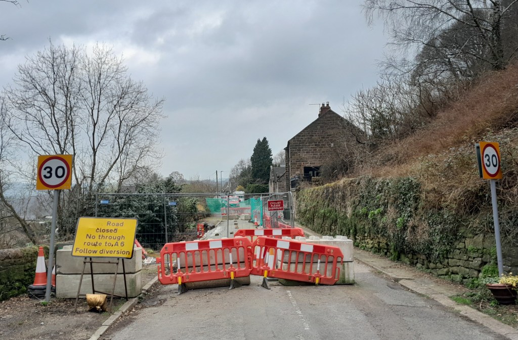
Leaving Holloway via Leashaw today
Curiously this road has been much in the news recently: firstly when the section near Cromford was eroded by the flooded Derwent in 2019, leading to a three-year closure, and now this year when a section of Leashaw slipped downhill due to heavy rain, leaving the road closed to all but cyclists and walkers. The house on the left was the toll cottage for this stretch of the turnpike. Currently there is no date for re-opening the route, despite the inconvenience for local people and businesses, and as can be seen in the picture, nobody actually at work!
Starting from Whatstandwell Bridge, if you follow the track from the hamlet of Robin Hood up through the quarry and wood to Wakebridge, and then on past Wakebridge Farm up to the top of the hill, the route finally levels off and you come to Shuckstone Fields, behind Holly Grange Farm and above Lea. This large field contains the intersection of five footpaths, and Shuckstone Cross must have marked this point. Today only the base remains, and the markings on this are illegible, but according to local historian George Wrigglesworth the four sides were marked C (for Crich) A (possibly Ashover) M (Mansfield or Matlock) and W (Wirksworth). In the late eighteenth century a pot containing Roman coins was dug up here, presumably buried by someone wanting a clear marker for their savings. Not far away is a ‘Holy Well’ of three compartments, which could have offered refreshment for travellers.
The Holy Well
The term ‘cross’ can be misleading: the crosses found in country churchyards, as at Eyam, had a cross shape and were often preaching crosses, while a cross as at Shuckstone was simply a stone shaft held in a square base which acted as a waymark or signpost. This marker would have been clearly visible at this high point (nearly 900 feet), which was moorland until a couple of hundred years ago: the 1791 map shows that the area was the southern tip of East Moor, an expanse of rough pasture which stretched from here north towards Chatsworth and then Sheffield.
The Cross may have also been a boundary marker, since the same map (Burdett’s) also shows that the track up from the Derwent runs along the old wapentake boundary, with the wapentakes of Wirksworth to the west and Morleyston to the east. According to Kenneth Cameron, (The Place-names of Derbyshire Part 2) the name ‘Shuckstone’ is fairly recent, and older records, going back to the Domesday Book, refer to this spot as ‘Shuckthorn’ or similar, meaning the Devil’s thorn tree. This is certainly a location well worth visiting, but probably not on a dark night.
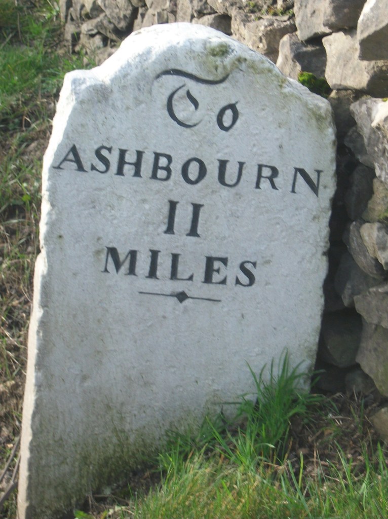
Milestone from Bakewell to Ashbourne turnpike, near Winster
As might be expected, the Romans were the first to use milestones in Britain. Theirs were usually stone cylinders, and a fragment of one is in Buxton Museum. Clearly, they had two useful functions: not only did they tell travellers how far they had to go, but at the same time they provided reassurance that they were on the right road. Unsurprisingly, no Roman milestones survive in situ, and they were not seen here again until the eighteenth century.
Milestone near Matlock Bath
The turnpike trusts seem to have re-introduced milestones on their routes, with each trust using a slightly different style, as seen in the two examples above. Spelling of place names is also non-standardized. Many of these survive, and provide a useful indicator of the routes of different trusts. For instance, on the Alfreton to Ashbourne route, between Crich and Carsington almost all the stones are still in place, although sometimes they are hidden in the undergrowth.
Milepost at Fritchley
In the early nineteenth century some trusts began using iron, possibly because it was cheaper to letter. The above example is on the Cromford to Langley Mill turnpike near Fritchley, and gives more information than the earlier models.
This super-milepost is also made of iron, and is found opposite the Red Lion in Wirksworth. Unusually, it has the name of the iron founders (Harrison of Derby) at the base. Wirksworth was on the route of the Nottingham to Newhaven turnpike, and horses were probably changed at the Red Lion. Newhaven was an important turnpike junction, where coaches would join the Ashbourne to Buxton road.
Finally, it’s worth noting that although today few people use milestones for travel, we still talk about them in everyday conversation, as in ‘she had reached a critical milestone in her life …’. Perhaps a reminder that, at least for pedestrians, every milestone passed was an achievement!
Travellers have always needed to drink, and so have their horses and dogs. Yet on the ancient ridgeways, crossing the limestone hills of north Derbyshire, there are few streams or ponds, and so providing drinking places has been critical. Stone troughs fed by springs are found by many old roads, though it is not clear who first installed them. The four horses needed to haul a stagecoach uphill for a mile or two would have needed a long drink by the time they reached the top of the climb.
St Alkmunds Well, Derby
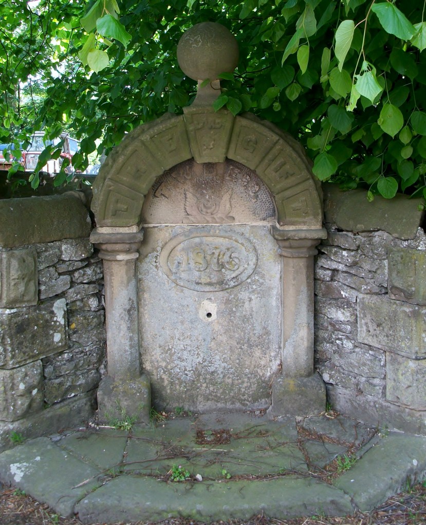
Wells were another source of water, though usually designed just for human use. and more commonly found in villages. Well dressing is a famous Derbyshire custom, and is normally seen as a celebration of a reliable and plentiful water supply – possibly pre-Christian, although now, as the example above shows, co-opted by the Church. Wells have frequently given their name to streets, as with Coldwell Street in Wirksworth or Coldwell End in Youlgrave. Others were sanctified with a saint’s name, such as St Alkmund’s well above, or St Anne’s well in Buxton. It seems likely that the tradition of ‘holy wells’ pre-dates the Reformation in 1539, and in some cases the water from these wells was thought to have a healing value.
Well in Youlgrave ‘The Gift’1876
Today it seems shocking how long it took to provide a piped, clean water supply in many Derbyshire villages. Youlgrave was unusual in that it installed its stone reservoir in the centre of the village in 1829 (below), from which local wells such as the one above were supplied. Even today Youlgrave still has its own water supply, independent of Severn Trent. But right up to 1940 nearby Elton people relied on carrying water in buckets from a spring at Burycliffe, half a mile from the village.
Water reservoir, Youlgrave
The names of some old wells can be found on large-scale OS maps, for example Lady Wall Well, north of Baslow on the old route over the moor to Sheffield. Sadly, many of these have become filled with rubbish and are easily overlooked. Cleaning and renovating a local well would be a valuable project for a volunteer neighbourhood group, and help to preserve a link with the not-so-distant past.