Cross purposes?

Stone south of Wirksworth at SK299521

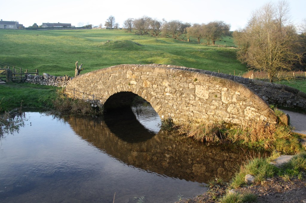
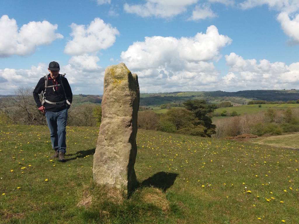
Derbyshire has plenty of stone, as shown by its characteristic dry-stone walls, and walkers may find pillars of stone, like the example above, set in the landscape for no apparent reason. Impossible to date, and clearly not redundant gateposts, they can only be assumed to mark some long-lost route. In other places there does seem to be a link to an old track, as with the large stone below, less than a mile above Wirksworth on the Brassington road, on the line of the Portway.

Again, it’s impossible to date a megalith like this, but clearly a lot of trouble was taken to erect what must have been a route marker. Given that many stones like these have been re-used for building, and others deliberately destroyed as symbols of paganism, we can imagine a prehistoric landscape well populated with such pillars. Surviving stone circles reinforce the idea of stones having power and importance, and this may have continued into the early Christian period, from about 600 CE.

Cross in Bradbourne churchyard

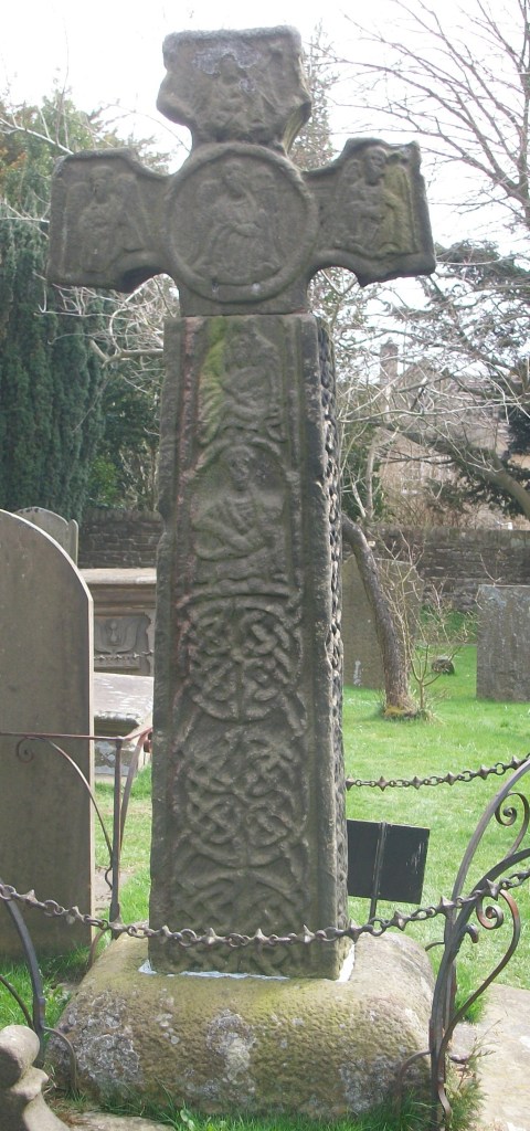
Presumably the first Christian missionaries set up ‘crosses’ like this example in Bradbourne as symbols of the new beliefs; although badly worn a crucifixion scene can be found near the base. Similar crosses can be seen at Bakewell church (found on Beeley Moor) and Stapleford, on the Portway in Nottinghamshire. Although referred to as crosses they are actually simple carved pillars, which suggests an attempt to Christianize a pagan symbol.

Stapleford Cross, with scrollwork and saint.

Both of these monuments are thought to date from the ninth century, far older than the church they adjoin. The cross was only adopted as a Christian symbol in 692 CE, and one of the earliest examples of the ‘new’ pattern can be seen at Eyam churchyard (part of the shaft appears to be missing). It is always possible that these crosses were moved into the churchyards at some point, and they may originally have been route markers.

Celtic scrollwork at Eyam

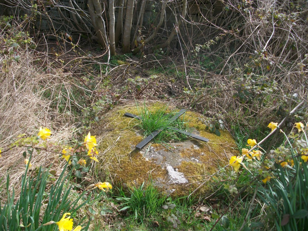
In Medieval Britain crosses became more common and varied: wayside crosses, boundary crosses, market crosses and later, memorial crosses. In some cases they may have had the dual role of showing the way and indicating the next pilgrim shrine; this cross base at Cross Lane near Dethick seems to mark a route that extended south to Shuckstone Cross, only a mile away, and beyond. These (now lost) crosses would have protected travellers as well as guiding them to the holy places.

Cross base near Dethick with anti-theft device

See: Sharpe, N. ( 2002) Crosses of the Peak District, Landmark

Farey’s footsteps

John Farey Esq.

John Farey (1766-1826) was a geologist and mathematician who wrote an extensive report on agriculture in Derbyshire, early in the nineteenth century. To research the subject he clearly had to travel widely, and this experience led him to produce a shorter report on the roads of Derbyshire in 1807. Finding his way around was clearly a concern, as he writes scathingly about the state of the milestones (‘too much neglected’) on account of the lack of maintenance: instead they are ‘shamefully defaced’ by ‘idle and disorderly persons’. Similarly the ‘way-posts or finger boards’ (i.e. signposts) ‘are entirely defaced’ with ‘scarcely a single inscription legible’. Despite this anti-social behaviour, Farey also notes the use of Latin on some ‘wayboards’, notably Via Gellia in Bonsall Dale and ‘Equus Via Longford’ near Shirley.

The Rutland Arms, Bakewell

He does, however, approve of the ‘many excellent Inns’ on the county’s turnpikes, and mentions the Rutland Arms at Bakewell, the Eagle and Child at Buxton, the King’s Arms at Derby and the New Inn at Kedleston, among others. As a geologist he notices that Peak Limestone is hard and so good for road building, but that Magnesian Limestone is easily crushed into a ‘gritty mire’. This was probably the first time that a such scientific approach to road construction had been made.

Farey also approvingly describes a feature of roads in the horse era that few historians have noted. He sees that ‘throughout the County’ cottagers’ children, women and old men are seen ‘perambulating certain lengths of the public Roads’, which they patrol regularly ‘carefully picking up every piece of horse-dung that falls’, and then carry their collections in baskets on their heads for sale to local farmers. Apparently shepherds on the few remaining commons did the same. Farey does not provide details of the going rate for a basket of horse dung, but the practice is an indicator of the depths of poverty in the pre-industrial world. He goes on to complain of the practice of turning cattle and horses out into the lanes to feed on the verges, saying that his horse had been upset by these semi-feral creatures. However, despite his criticisms, Farey rates this county’s roads positively: ‘… after paying a good deal of attention to this subject in most parts of England, I think few of the counties excel Derbyshire as to its roads …’ .

Comings and goings at Haddon

Desirable gentleman’s residence

Haddon Hall, near Bakewell on the River Wye is such a remarkably well-preserved late medieval house it has been irresistible to film makers. Firebrand, the story of Henry VIII and Katherine Parr, is currently on release, and previously Haddon has been the setting for two versions of Jane Eyre (involving burning the building down), Pride and Prejudice, and many others. In the mid-sixteenth century it was the home of Sir George Vernon (born 1503), whose steward kept an account book which gives us a glimpse of the network of transport links which sustained life in a great house at that time.

George Vernon at rest in Bakewell church

The accounts for the Christmas period 1564-5 include payments to entertainers as well as for food and drink. ‘The Earl of Worcester’s players, presumably a travelling theatre group, earned 14/3d (fourteen shillings and threepence), while ‘Wetton the minstrel and his fellows’ were paid over 30/- (nearly £600 in modern values). Hawkers must have been welcome visitors, since John Basford and ‘other hawkers’ were given a Christmas tip of 10/-. Drink was bought in huge quantities: the ‘tenants of Baslow’ were paid 12/3 for bringing a tun (supposed to be 250 gallons, but hard to believe this could be transported) of wine to the Hall, while a gallon of malmsey ‘for the cook’ cost only 2/-. Food was bought from various local markets, especially Chesterfield and Ashbourne, but also Lenton fair near Nottingham, and Derby. ‘Shoes for kitchen boys’ came from Bakewell (5/4), while 3 crannocks of salt cost 30/-, with carriage an extra 10/- (presumably carted from the ‘wiches’).

George Talbot, 6th Earl of Shrewsbury

The accounts also reveal regular travel between Haddon and Sheffield. ‘One of my mistress’s men’ was paid 2/- for carrying a letter to ‘my lord of Shrewsbury’ in Sheffield. At this time George Talbot was the Earl of Shrewsbury, who would soon (in 1567) marry Bess of Hardwick. On the 19th of September 1564 George Vernon had gone to Sheffield, presumably to visit Shrewsbury, and was provided with 10/- ‘to play at dice’. He must have gone with an entourage, since it cost 27/- to put them up in Sheffield for five nights. On the way home 4d was spent on ‘bread, cheese and drink’ for the men at Holmsfield, a village on a direct route from Sheffield to Haddon. Clearly a source like this raises as many questions as it answers, but nevertheless does give some fascinating insights into travel nearly 500 years ago.

Sources

Carrington, W. (1894) ‘Selections from the steward’s accounts preserved at Haddon Hall’. DAJ XVI pp 61-85

Hey, D. (2001) Packmen, Carriers and Packhorse Roads. Landmark pp 136-7

‘There is not a finer county in England than Derbyshire’

Jane Austen 1775-1817

A significant tourist industry has grown up around Jane Austen and Derbyshire. It is often claimed that she visited the county in 1811, stayed at the Rutland Arms in Bakewell, looked around Chatsworth and based Mr Darcy’s fictional house of Pemberley on this model. At least one film of Pride and Prejudice has used Chatsworth as a setting. However, there is no actual evidence that Jane ever visited the county, let alone wrote about it.

As it wascould this have been Pemberley?

In Pride and Prejudice the heroine, Elizabeth Bennet, is taken on a tour of the Peak District by her aunt and uncle. There is mention of Matlock, Chatsworth, Dovedale and the Peak as being the main attractions. They base themselves in ‘Lambton’, often taken to be Bakewell, from where Pemberley is a three-mile drive. When they visit the house its setting makes a positive impression on Elizabeth: ‘…it was a large handsome stone building, standing well on rising ground, and backed by a ridge of high, woody hills – and in front a stream of some natural importance is swelled into greater …’ . This description has encouraged the identification with Chatsworth, but there are three objections to the theory. First, as mentioned above, there’s no record of her visiting the area, second the description of the house is generic, and could apply to many mansions from this period. Landscape fashion from the eighteenth century had created dozens of similar park-like vistas and Austen would have seen engravings such as the one above. Finally Pride and Prejudice, although only published in 1813, was largely written in 1797, 11 years before her supposed visit to the county.

A post-chaise

The search for originals of fictional people and places is quite pointless, since it assumes that authors have no powers of invention. More interesting is the light that the story sheds on early tourists in the Peak. Even if she had never visited Derbyshire, Austen was well aware of the tourist sights, which wealthy travellers could best enjoy by hiring a chaise, a small light carriage for two or three people. Complete with driver, this would cost about a guinea a day, roughly £100 in modern money.

Bridge building

Below Matlock bridge

In the current dry weather it’s quite easy to climb down and inspect the underside of the arches of Matlock bridge, a structure thought to date from the fifteenth century. As can be seen in the photo, this reveals a clear joint between the original structure and the widening carried out in 1904, which allowed two-way traffic on the bridge (since reduced to one-way in the latest traffic scheme). This is a reminder that most pre-twentieth century bridges would have only been wide enough for one cart or coach at a time, as is still the case with One-Arch Bridge at Chatsworth.

Holme Bridge north of Bakewell

Some were still narrower, such as Holme Bridge, on the River Wye upstream of Bakewell; just wide enough for a train of packhorses to cross. This is a reminder that bridge building was high skilled and thus expensive, yet bridges were absolutely critical to the transport network. The earliest bridges probably had a wooden superstructure resting on stone piers: easier to construct but liable to be washed away in any flood. All-stone bridges, with arches and breakwaters to deflect floating debris, were commonly constructed from the twelfth century but their cost was often met by a local monastery or abbey. In addition, tolls were frequently charged to pay for their upkeep.

St Mary’s bridge chapel, Derby

Important river crossing often had chapels attached, as with St Mary’s bridge in Derby (the only bridge in medieval times) or Cromford bridge (now ruined). The chapels would have provided a shrine for travellers to pray for a safe onward journey, and doubtless to leave an offering for bridge maintenance.

Bridge over River Bradford at Youlgrave

With most ancient bridges, establishing a date is almost as difficult as dating a road. The example above, with its simple round arch, and too narrow for a cart, could be anything from a hundred and fifty to a thousand years old, and would probably have been repaired many times after especially violent floods.

The two Williams

St Anne’s, Beeley

Diaries can be a useful source in studying travel patterns in the past. William Hodkin was a farmer and general dealer at Beeley, on the Chatsworth estate in the mid-nineteenth century. He kept a diary, mainly of his farming work, from 1864 to 1866, which reveals the shape of his trading network. Although the station at Rowsley was open at this time he made relatively little use of the railway, either riding on horseback or travelling with a cart when collecting or selling livestock or deadstock.

During two and a half months April to June 1864 he travelled to Bakewell 13 times, to Calton Lees 5 times, and to Chesterfield, Beeley Moor and Rowsley 4 times each. Other trips took him to Ashford, Matlock and Edensor. Interestingly, the state of the roads is never discussed: presumably he knew them all so well that there seemed no need to mention it, although he does once mention that his horse had collapsed on the steep hill to Chesterfield.

Hilltop House, Beeley, one of William’s regular destinations

It has to be admitted that William Hodkin was no Pepys. A typical entry (Thursday July 5th, 1864) reads: ‘Went rabbitting in the morning, making bills out at night. Father not doing much Thomas thrashing John carting stone to the highways’. This last job is a reminder that the roads around Beeley were not then tarmaced, and were still maintained by local labour. His wife is only referred to as ‘The Mrs’, although there are frequent mentions of the weather, and the occasional reference to the vicar’s sermon shows that William did sometimes take time off.

William’s landlord, William Cavendish, 7th Duke of Devonshire

The way through the woods

In Bow Wood near Lea Bridge

Over time, many routes have been abandoned, due to changes in settlement patterns, agriculture or the construction of better, easier roads. The medieval route through Bow Wood from Castletop farm to Lea Bridge, shown above, is now a rough track, but its previous status is revealed by the stone gateposts, indicating a width suitable for carts or carriages.

The image of the lost road has always had romantic appeal, an appeal explored by Kipling in his poem ‘The way through the woods’:

They shut the road through the woods

Seventy years ago.

Weather and rain have undone it again,

And now you would never know

There was once a road through the woods

Before they planted the trees.

It is underneath the coppice and heath

And the thin anenomes.

Only the keeper sees

That, where the ring-dove broods,

And the badgers roll at ease,

There was once a road through the woods.

Yet, if you enter the woods,

On a summer evening late,

When the night-air pools on the trout-ringed pools

Where the otter whistles his mate,

(They fear not men in the woods,

Because they see so few)

You will hear the beat of a horse’s feet,

And the swish of a skirt in the dew,

Steadily cantering through

The misty solitudes,

As though they perfectly knew

The old lost road through the woods …

But there is no road through the woods.

The pre-turnpike road from Rowsley to Bakewell

Today some of the ‘lost roads’ survive as footpaths with public rights of way, kept open by dog walkers and hikers. However, especially in high summer when the vegetation reaches shoulder height, and encroaches on the path from both sides, it is easy to see how fast an unsurfaced route can disappear. Perhaps the surprising thing is the number of roads that have survived over hundreds or thousands of years, rather than those that have disappeared.