Snowmotion

A recent winter view of Youlgreave

Winter has never been the best season for travel, but in the past it must have been far more difficult than today. Not only were roads much worse, but at times the weather seems to have been much colder. Especially in the upland areas of Derbyshire farms and villages were likely to be cut off by snowdrifts, with the constant threat of hunger if people were unable to reach markets. According to the Youlgreave Churchwardens’ records:

This year 1614 began the greatyst snow that ever fell within many memorye. And for heaps or drifts of snow they were very deep; so that passengers both horse and foot, passed over gates and hedges and walls it fell at ten severall times, and the last was the greatest … it continued by daily increasing until 12th day of March …

Snowdrifts at Farley above Matlock in 1947

The freezing winter of 1947, still within living memory, was made worse by the decrepit nature of the country’s infrastructure, worn out by years of war. Heavy snow began in late January and continued well into March. Conditions were primitive in many parts of Derbyshire, as recorded by a Mrs Alsop of Hulland Ward near Ashbourne:

All the local men were called by the council to leave their jobs to help clear the roads. This was all done by hand and shovels – no mechanical diggers in those days. The strong northeast, gale-force winds daily filled the roads. The men worked seven days a week for six weeks or more. … Younger folk trudged to Ashbourne (five miles or more) for bread.

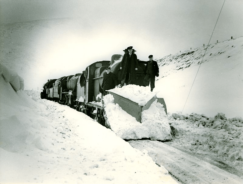
In the Peak conditions were worse and neither roads or railways could be kept open, despite heroic efforts. Around Buxton, Longnor and the Staffordshire side of the Dove valley bombers were used to supply isolated settlements. Thousands of pounds of flour, sugar, jam and tinned goods were dropped by parachute. Tragically, one of the planes crashed on Grindon Moor, killing all eight on board. The weather finally relented in early March, when the landlord and landlady of the Barrel Inn at Bretton could leave the bedroom where they had been trapped for the past five weeks, having been dug out by rescuers.

Source: The Derbyshire and Nottinghamshire Weather Book (1994) Markam, L.

Milestoned?

Milestone from Bakewell to Ashbourne turnpike, near Winster

As might be expected, the Romans were the first to use milestones in Britain. Theirs were usually stone cylinders, and a fragment of one is in Buxton Museum. Clearly, they had two useful functions: not only did they tell travellers how far they had to go, but at the same time they provided reassurance that they were on the right road. Unsurprisingly, no Roman milestones survive in situ, and they were not seen here again until the eighteenth century.

Milestone near Matlock Bath

The turnpike trusts seem to have re-introduced milestones on their routes, with each trust using a slightly different style, as seen in the two examples above. Spelling of place names is also non-standardized. Many of these survive, and provide a useful indicator of the routes of different trusts. For instance, on the Alfreton to Ashbourne route, between Crich and Carsington almost all the stones are still in place, although sometimes they are hidden in the undergrowth.

Milepost at Fritchley

In the early nineteenth century some trusts began using iron, possibly because it was cheaper to letter. The above example is on the Cromford to Langley Mill turnpike near Fritchley, and gives more information than the earlier models.

This super-milepost is also made of iron, and is found opposite the Red Lion in Wirksworth. Unusually, it has the name of the iron founders (Harrison of Derby) at the base. Wirksworth was on the route of the Nottingham to Newhaven turnpike, and horses were probably changed at the Red Lion. Newhaven was an important turnpike junction, where coaches would join the Ashbourne to Buxton road.

Finally, it’s worth noting that although today few people use milestones for travel, we still talk about them in everyday conversation, as in ‘she had reached a critical milestone in her life …’. Perhaps a reminder that, at least for pedestrians, every milestone passed was an achievement!

Conquering the stoop

Guide stoop at top of Crowhill Lane near Bakewell

Nearly fifty of these stone pillars survive in Derbyshire, providing vital clues to the medieval road network. ‘Stoop’ is a Scandinavian word for stone, and they have proved suitably durable, many surviving for over three hundred years. They were erected about 1709 to (belatedly) comply with an Act of 1697 which required direction stones to be put up at road junctions in remote moorland areas, where travellers would be likely to get lost. The majority have inscriptions on four sides, and these should indicate the direction of the nearest market towns. The example above shows a hand pointing to ‘Bakewel’, while the other sides indicate the directions of Tideswell, Buxton and Winster. It is notable that the stone now stands at a T-junction; the fourth route was closed with the opening of the turnpike road on what is now the nearby A6.

Guidestoop above Winster on road to Grangemill

This illustrates one of the values of these stoops: they show the routes that were in use pre-turnpike and pre-maps. The Winster stoop, above, provides another example. It is thought that originally it stood at the end of Bonsall Lane, and indicates Wirksworth, Bonsall and Bakewell. The fourth town marked, however, is Leek, over 15 miles away via Pikehall, but clearly a significant destination at that time. As with some other guide stoops, this one has been used as a gatepost, since most stoops would have become redundant with the arrival of better signposted turnpikes later in the eighteenth century. Nearby, at Shothouse Spring, another stoop (on private land) is no longer on any road or path, although it was clearly erected at a one-time crossroads.

Guidestoop at Alport Height

The Alport stone (showing Derby, Wirksworth and Ashbourne) is another example of a stoop at an apparently remote junction, but clearly thought worth marking in 1709. In fact its position on the Portway suggests that it would have been a more important route at that time. To properly envisage early eighteenth century travel we need to remove most of the dry stone walls and grassy pasture, and go back to a landscape of open scrubby moorland, crossed by the occasional track. In this setting it is easier to imagine the reassurance that the guidestoop would have given the uncertain traveller.

(For a detailed guide to all surviving stoops see ‘The Guide Stoops of Derbyshire’ by Howard Smith)