Tolls, riots and Rebeccas

Toll cottage and toll gate at the National Museum of History in St Fagan’s.

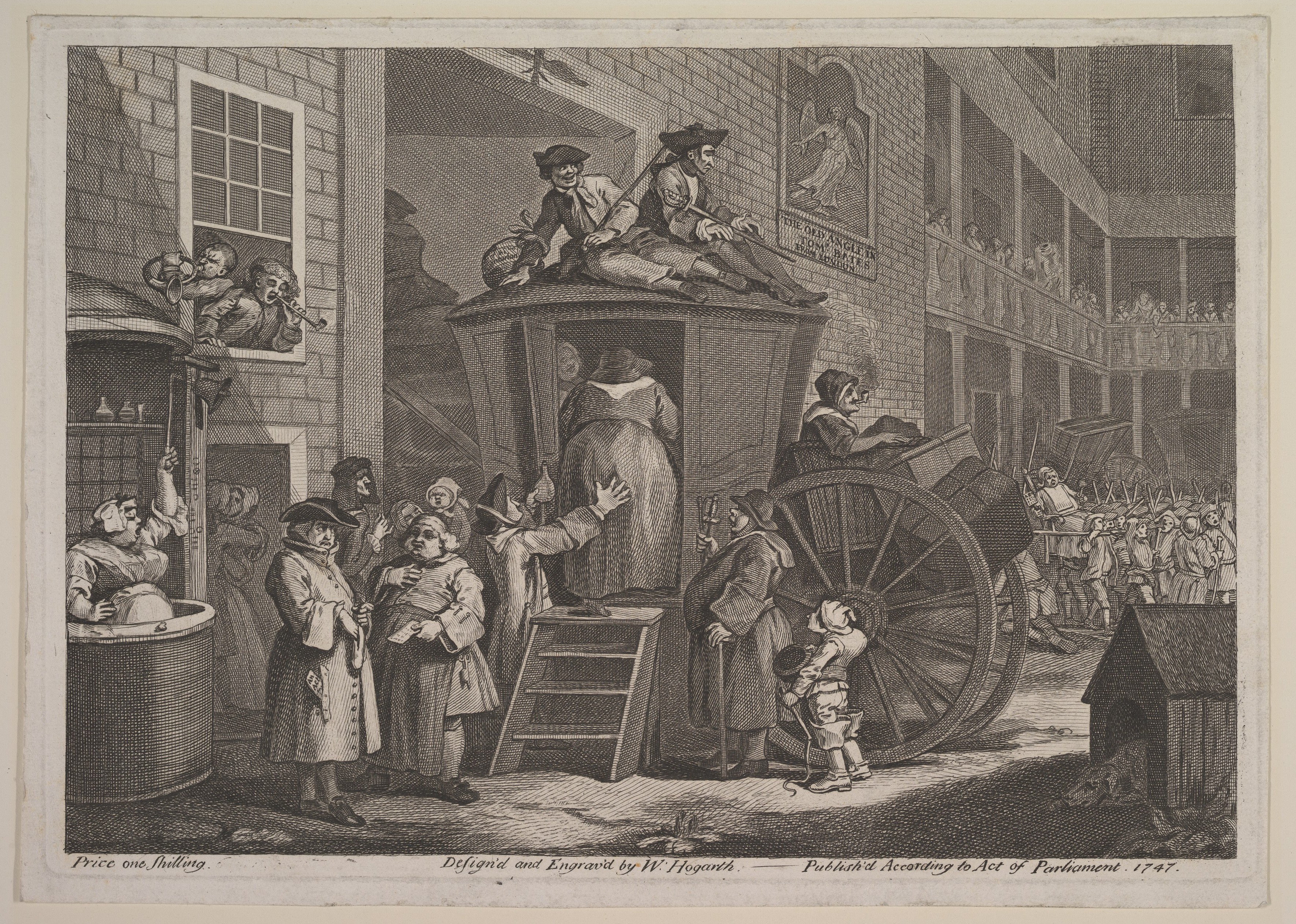
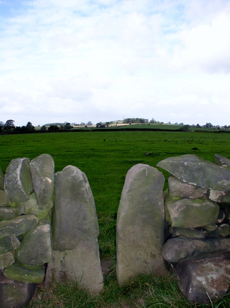
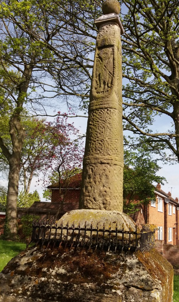
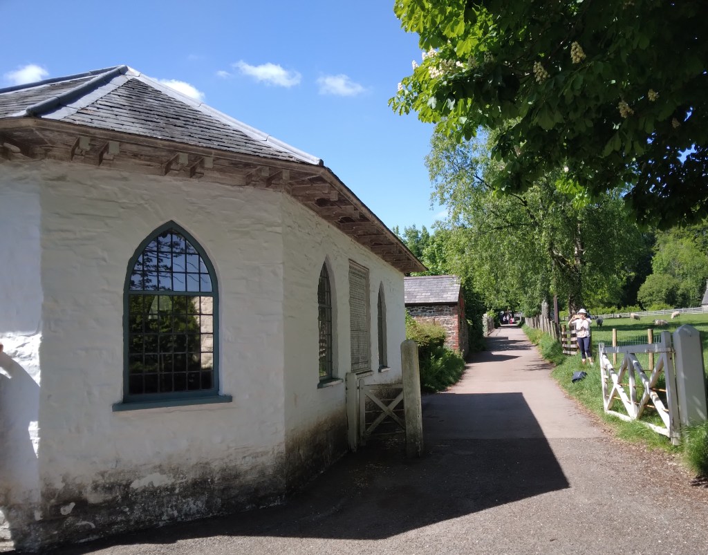
Many toll houses survive in Derbyshire (see previous blogs) but the only surviving ensemble of cottage, gate and board of charges is found at the National Museum of Wales, near Cardiff. This was moved to the Museum from its original location near Aberystwith. The list of charges (see below) gives a fascinating insight into the traffic that used the turnpike roads in the early nineteenth century. Sixteen different kinds of horse-drawn passenger vehicles are listed, including chariot, Berlin, landau, chaise, phaeton, vis a vis and calash – all charged at six pence per horse (over £2 at modern values). Agricultural traffic was rated at four pence per animal, unless the cart was pulled by an ass, in which case it was only two pence. Droves of large animals like cattle cost the drover ten pence per score, while flocks of sheep were only five pence. It is easy to imagine the disputes that could have arisen about whether an animal was a cow or a calf (half price) or how many animals were in a drove!

The list of exemptions is also revealing. Farmers leading horses to work on the adjoining fields were free of charge, as were attendees at Sunday services, or funerals. Waggons carrying vagrants or prisoners were also free, as was military traffic and clergy doing parish business, sheep going to be washed and people taking part in county elections. Again, there seems to be plenty of scope for argument in such a lengthy list!

A contemporary image of the Rebecca riots

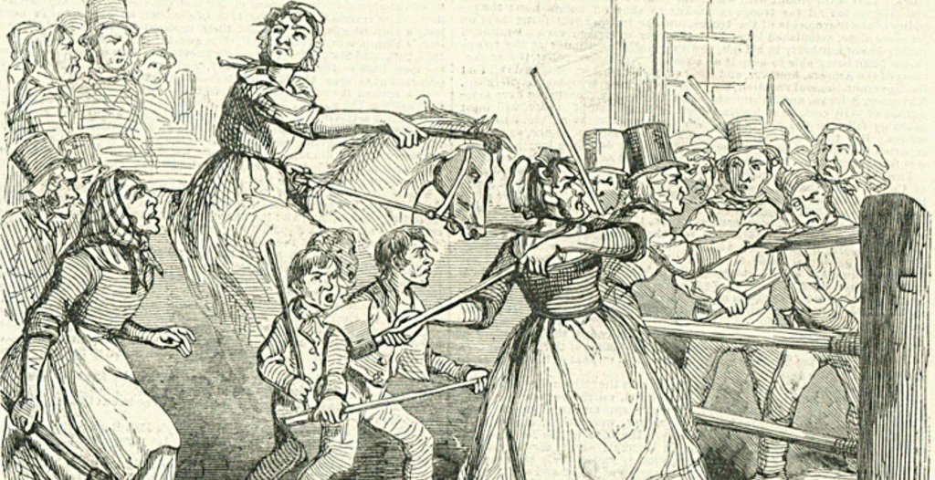
Despite these exemptions, ordinary people commonly hated the turnpikes, which seemed to take away a basic freedom – to use the ‘King’s highway’ without paying. This was especially the case in Wales, where an agricultural depression between 1839-42 caused widespread misery. This lead directly to the Rebecca riots, when protesters disguised themselves in women’s clothing and attacked and burned the toll gates, which had come to represent the general burden of taxation on the poor.

The Waters of Life and Death

Burycliffe Troughs, Elton

It is easy to forget the significance of a good water supply for both residents and travellers, something which is taken for granted today. But less than a century ago, up to 1940, the village of Elton was dependent for its water on Burycliffe Troughs, half a mile away, water which had to be laboriously carried by householders in buckets. Yet nearby Youlgrave had built its own water system in 1829, as indicated on its central cistern. Though this is not in use today, the village still maintains its independent supply, and provides it much cheaper than Severn Trent!

Youlgrave cistern

In nineteenth-century villages water was not usually piped to individual houses. Instead villagers collected it from wells scattered around, like this attractive example, also from Youlgrave, titled ‘The Gift’ and dated 1876. Similar examples can be found in many Derbyshire settlements.

The Gift, Youlgrave

Springs and wells had symbolic value in Christianity (and probably also in pagan beliefs). A late example of this is St John’s chapel in St John’s Road, Matlock Bath, a remarkable Arts and Crafts structure of 1895 built over a well, presumably a reference to St John as baptist. The stained glass windows also illustrate ‘The Waters of Life’ and ‘The Waters of Death’.

Well below St John’s chapel.

Many drinking troughs and wells can be found outside villages, as a critical part of the old transport infrastructure. The spring-fed example below, found near the top of the long climb out of Wirksworth and just below the Malt Shovel crossroads, would have provided a welcome drink for horses labouring up the incline, as well as for cattle and other animals being driven to and from market.

Drinking well on Wirksworth – Whatstandwell Road

Sadly, many of these wells have become choked with debris and allowed to dry up. It would be a positive addition to the landscape if they were cleaned and restored – and any passing horses would be very thankful.

Stagecoach

William Hogarth | The Stage Coach, or Country Inn Yard | The Metropolitan  Museum of Art
Loading the stagecoach – Hogarth

The romantic image of the stagecoach, as seen on hundreds of Christmas cards, portrays the coach’s arrival at a snowy inn, horns being blown to warn the landlord to make ready for the hungry passengers. But the real experience must have been less glamorous: unheated and crowded. Travel by stagecoach became quicker and somewhat more comfortable during the later eighteenth century, thanks to better turnpike roads and steel springs. However, it was always expensive and never popular, many men and some women preferring to ride their own (or hired) horses. Hogarth’s print satirises the discomforts of being squeezed into a small compartment for a long day’s journey, while those travelling ‘outside’ (at cheaper rates) were always in danger of falling off. But by the early nineteenth century the trip from Derby to London could be done in one long day, saving the expense of hotels enroute.

Peacock Hotel, Four Lane Ends, Oakerthorpe, near Alfreton, c 1950?s
The Peacock, Oakerthorpe in the 1950s

Stagecoaches were so-called as they had to travel in stages, changing horses every 10-12 miles. Pulling such a heavy load (at least half a dozen passengers, the coachman and the coach) horses needed to be rested after that distance. Consequently coaching inns were built in most towns served by stagecoach routes, but also at strategic points along the roads. They can often be identified by an arch to allow the coach to enter the yard behind, as at the Red Lion in Wirksworth. The Peacock at Oakerthorpe (now called Pestos at the Peacock) was sited at the junction of two important turnpikes: Nottingham – Newhaven and Derby – Chesterfield. The name ‘Peacock’ suggests a connection with the Duke of Rutland, whose family symbol this is. Another coaching inn financed by a great Derbyshire landowner was the Newhaven Hotel, built by the Duke of Devonshire at the junction of the Nottingham turnpike with the Derby – Buxton route.

The Red Lion, Wirksworth

The growth of travel by stagecoach led to the development of a huge ‘horse economy’, requiring not only coachmen but ostlers, farriers, chambermaids, cooks and other indoor staff. The larger inns would have stabled at least 100 horses. This all went into decline after 1840, as the railways spread over the country and provided much cheaper and more comfortable travel, although in the more remote parts of Derbyshire stage coaches continued in use to the 1880s.

The secrets of Shuckstone

The cross base, with dandelions, looking east

Starting from Whatstandwell Bridge, if you follow the track from the hamlet of Robin Hood up through the quarry and wood to Wakebridge, and then on past Wakebridge Farm up to the top of the hill, the route finally levels off and you come to Shuckstone Fields, behind Holly Grange Farm and above Lea. This large field contains the intersection of five footpaths, and Shuckstone Cross must have marked this point. Today only the base remains, and the markings on this are illegible, but according to local historian George Wrigglesworth the four sides were marked C (for Crich) A (possibly Ashover) M (Mansfield or Matlock) and W (Wirksworth). In the late eighteenth century a pot containing Roman coins was dug up here, presumably buried by someone wanting a clear marker for their savings. Not far away is a ‘Holy Well’ of three compartments, which could have offered refreshment for travellers.

The Holy Well

The term ‘cross’ can be misleading: the crosses found in country churchyards, as at Eyam, had a cross shape and were often preaching crosses, while a cross as at Shuckstone was simply a stone shaft held in a square base which acted as a waymark or signpost. This marker would have been clearly visible at this high point (nearly 900 feet), which was moorland until a couple of hundred years ago: the 1791 map shows that the area was the southern tip of East Moor, an expanse of rough pasture which stretched from here north towards Chatsworth and then Sheffield.

The Cross may have also been a boundary marker, since the same map (Burdett’s) also shows that the track up from the Derwent runs along the old wapentake boundary, with the wapentakes of Wirksworth to the west and Morleyston to the east. According to Kenneth Cameron, (The Place-names of Derbyshire Part 2) the name ‘Shuckstone’ is fairly recent, and older records, going back to the Domesday Book, refer to this spot as ‘Shuckthorn’ or similar, meaning the Devil’s thorn tree. This is certainly a location well worth visiting, but probably not on a dark night.

A choice of paths

The style of stiles

Since the nineteenth century stiles have been a familiar feature of the rural landscape, providing a bucolic focus for pictures of simple country folk or lovers’ trysts. Before the enclosure of moors and commons stiles weren’t needed, but with the arrival of hedges and dry stone walls access was needed for pedestrians. ‘Stile’ comes from the old German word ‘stigel’ which means to climb or go over.

Squeeze stile near Alport Height

Squeeze stiles are a distinctive feature of the Derbyshire landscape. They are simple to pass through, but clearly are only effective if too narrow for sheep to slip between, and so can prove quite tricky for the overweight! They have the advantage of clearly marking the route of a path, so that when entering a field you can normally see the next stile ahead, and aim for that. Very occasionally the stile stones are dated, as in the example below at Lea, which suggests that this area was enclosed about 1780.

Other types of stile are with wooden steps, or stone steps let into a wall. Both can be more difficult for walkers if not well-maintained, and an upright wooden post should be provided for hand support. Dogs can also find stiles tricky, so the ideal model has a dog gate which can be raised when needed. But today there is a move to replace stiles with gates, more convenient for elderly walkers but also requiring more maintenance – and easily left open.

Stile and gate near Holbrook

Beyond their practical function, stiles can be seen as fossilised markers of footpaths, possibly 250 years old in many cases, but indicating routes that were in existence before the enclosures and which had to be preserved subsequently. In places the paths they serve could be medieval, and may once have been a long-distance road, now merely a Sunday ramble.

Milestoned?

Milestone from Bakewell to Ashbourne turnpike, near Winster

As might be expected, the Romans were the first to use milestones in Britain. Theirs were usually stone cylinders, and a fragment of one is in Buxton Museum. Clearly, they had two useful functions: not only did they tell travellers how far they had to go, but at the same time they provided reassurance that they were on the right road. Unsurprisingly, no Roman milestones survive in situ, and they were not seen here again until the eighteenth century.

Milestone near Matlock Bath

The turnpike trusts seem to have re-introduced milestones on their routes, with each trust using a slightly different style, as seen in the two examples above. Spelling of place names is also non-standardized. Many of these survive, and provide a useful indicator of the routes of different trusts. For instance, on the Alfreton to Ashbourne route, between Crich and Carsington almost all the stones are still in place, although sometimes they are hidden in the undergrowth.

Milepost at Fritchley

In the early nineteenth century some trusts began using iron, possibly because it was cheaper to letter. The above example is on the Cromford to Langley Mill turnpike near Fritchley, and gives more information than the earlier models.

This super-milepost is also made of iron, and is found opposite the Red Lion in Wirksworth. Unusually, it has the name of the iron founders (Harrison of Derby) at the base. Wirksworth was on the route of the Nottingham to Newhaven turnpike, and horses were probably changed at the Red Lion. Newhaven was an important turnpike junction, where coaches would join the Ashbourne to Buxton road.

Finally, it’s worth noting that although today few people use milestones for travel, we still talk about them in everyday conversation, as in ‘she had reached a critical milestone in her life …’. Perhaps a reminder that, at least for pedestrians, every milestone passed was an achievement!

The name of the lane

Road name near Holbrook

Although name signs like this are relatively modern, roads have been named for hundreds of years, and today road names are a useful resource for historians. We do not know what names the Romans actually gave their routes, but after their departure they were called ‘streets’ as in Ryknild Street, which ran from Derby to Chesterfield. Many place names e.g. ‘Stretton’ reflect this. Anglo-Saxons used the noun ‘way’ for their roads, and this survives in many expressions such as ‘highway’ and ‘byway’. The word ‘road’ was not common until the seventeenth century, and may be derived from the verb ‘rode’.

The most obvious type of name gives the destination of the road, hence Chesterfield Road or Brassington Lane. Another refers to some feature found on the road, either natural or man-made, such as Chapel Lane or Cuckoostone Lane. In the case of an ancient route like Hearthstone Lane, running from Cromford to Riber, there is no obvious Stone, raising the question ‘Where was it?’

Hermitage Walk, Nottingham

This sign in The Park in Nottingham is a valuable clue that the ‘Walk’ led to an ancient group of caves (now inaccessible) that contained a rock-cut chapel. Other names refer to the state of the road: Long Lane, Marsh Lane, New Road. In this last case, the name suggests that there is an ‘old road’ that could be investigated.

Many road names refer to natural features using archaic vocabulary. ‘Shaw’ or ‘Carr’ names are common in Derbyshire, and mean a wood on a steep slope, as in Leashaw, Upper Holloway. ‘Sitch’ is Anglo-Saxon for a small stream. ‘Well’ endings as in Bakewell suggest a natural spring.

A few names refer to an individual, either familiarly in ‘Samuel’s Lane’ or more grandly with ‘Via Gellia’, named by Anthony Gell, the road developer, after himself in pseudo-Roman style.

Road sign on the Ridgeway near Heage

But there will always be names that elude discovery, or can only be the subject of wild guesswork. What’s the story behind Lickpenny Lane, for instance, or the Clatterway at Bonsall? Or did Wapentake Lane near Kirk Ireton really lead to the site of the ancient Wapentake?

Crossed out?

Cross in Eyam churchyard

Anyone who has travelled in the more Catholic parts of Europe such as Bavaria or Brittany may have seen the roadside crosses which frequently mark the route. Medieval England would probably have had the same, until various acts of parliament after the Reformation ordered their removal as ‘Popish elements’. The cross was obviously the symbol of Christianity (after 692 CE), and it is thought that they were erected for three reasons: as a base for preaching before churches were built, as a waymark for travellers (particularly pilgrims approaching a shrine), and to mark the boundary of monastic estates. In addition to these religious uses, crosses often marked the site of a weekly market.

Morley Cross, in the churchyard but probably a market cross.

Perhaps because it is relatively remote, Derbyshire is quite rich in the remains of crosses, although the great majority must have been destroyed or lost. Eyam Cross (above) is one of the finest and oldest, although even here a section of the shaft is clearly missing. It is thought to be Saxon work from the ninth century, and its original location is unknown. Not all early crosses had a cross arm: Stapleford Cross (on the Notts/Derby border, below) is simply a shaft with carvings.

Stapleford Cross, which marked the point where the Portway entered Nottinghamshire.

When I first saw the road name ‘Cross Lane’ I assumed it referred to a crossroads, but eventually realised it referred to an actual cross or crosses. One example is at Dethick, where the cross base still survives, half hidden in the undergrowth. But there are others (e.g. at Wessington) which would be worth investigating. Presumably these crosses marked the route to some pilgrimage destination, as would some rare survivals in north Derbyshire such as Wheston.

Wheston Cross, guarded by geese.

Clearly this is a subject which offers plenty of scope for further research by historians, since there are now so few traces of what must have been a significant feature of medieval life. A good starting point is Neville Sharp’s excellent book: Crosses of the Peak District, which includes crosses in parts of Cheshire and Staffordshire.

Wells, springs and troughs

Dressed well, Tissington

Travellers have always needed to drink, and so have their horses and dogs. Yet on the ancient ridgeways, crossing the limestone hills of north Derbyshire, there are few streams or ponds, and so providing drinking places has been critical. Stone troughs fed by springs are found by many old roads, though it is not clear who first installed them. The four horses needed to haul a stagecoach uphill for a mile or two would have needed a long drink by the time they reached the top of the climb.

St Alkmunds Well, Derby

Wells were another source of water, though usually designed just for human use. and more commonly found in villages. Well dressing is a famous Derbyshire custom, and is normally seen as a celebration of a reliable and plentiful water supply – possibly pre-Christian, although now, as the example above shows, co-opted by the Church. Wells have frequently given their name to streets, as with Coldwell Street in Wirksworth or Coldwell End in Youlgrave. Others were sanctified with a saint’s name, such as St Alkmund’s well above, or St Anne’s well in Buxton. It seems likely that the tradition of ‘holy wells’ pre-dates the Reformation in 1539, and in some cases the water from these wells was thought to have a healing value.

Well in Youlgrave ‘The Gift’ 1876

Today it seems shocking how long it took to provide a piped, clean water supply in many Derbyshire villages. Youlgrave was unusual in that it installed its stone reservoir in the centre of the village in 1829 (below), from which local wells such as the one above were supplied. Even today Youlgrave still has its own water supply, independent of Severn Trent. But right up to 1940 nearby Elton people relied on carrying water in buckets from a spring at Burycliffe, half a mile from the village.

Water reservoir, Youlgrave

The names of some old wells can be found on large-scale OS maps, for example Lady Wall Well, north of Baslow on the old route over the moor to Sheffield. Sadly, many of these have become filled with rubbish and are easily overlooked. Cleaning and renovating a local well would be a valuable project for a volunteer neighbourhood group, and help to preserve a link with the not-so-distant past.

Dark Lanes and Holloways

Longwalls Lane above Blackbrook

How many ‘Dark Lanes’ can you find on the Ordnance Survey maps of Derbyshire? I know several, for example the one running from Wheatcroft towards Plaistow Green, but there are probably more. In practice these lanes are usually shady holloways, so that the meaning of the name is obvious. But what is the origin of holloways, which are found all over the county, though more commonly on sloping ground?

Over hundreds of years’ use, these tracks, which were most likely no more than packhorse routes, became eroded by the constant wear and tears of hooves and boots. Rain would erode the surface soil until bare rock was reached, as can be seen on Longwalls Lane above. There may well be a relation between the depth of the holloway and the age of the route, though that would be difficult to calculate. But what is clear is that a deep cut lane, lying a yard or more below the surrounding fields, must be several hundred years old.

Holloway near Lea

The picture above shows a good example of an ancient holloway, running between Lea and Upper Holloway. Unusually it can be partly dated from an adjacent stile stone (below) of 1780, meaning that the holloway was in use 240 years ago (and probably many more). A steep road in Holloway, leading up to the moor, is called The Hollow, and must have linked to the Lea route as well as giving the village its name.

Dated squeeze stile, Lea

Over time, some holloways became waterlogged, especially in winter, forcing road users to travel alongside. The old path bottom gradually became overgrown and clogged with saplings and brambles, so that the right of way moved parallel but above. Today it seems reasonable to estimate that any holloway is earlier than an enclosure road (most of which date to the early nineteenth century), and may well indicate the local medieval road network.