Canal competition

Leawood pump house in steam

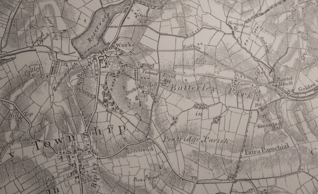
For thousands of years goods had to be carried by roads, and a horse and cart could move about a ton of stone or coal. But with industrial growth in the eighteenth century increasing demand for raw materials canals became a feasible mode of transport, a horse-drawn narrowboat could carry 30 tons. From about 1760 the canal network grew quickly, and by 1788 a route was planned from Cromford to Langley Mill, where it would link up with the Erewash Canal and so gain access to the Trent basin. Local entrepreneurs such as Gell at Hopton and lead smelters at Lea and Crich were keen to promote this facility for their minerals, while also benefiting from cheaper coal deliveries.

The aqueduct at Bullbridge

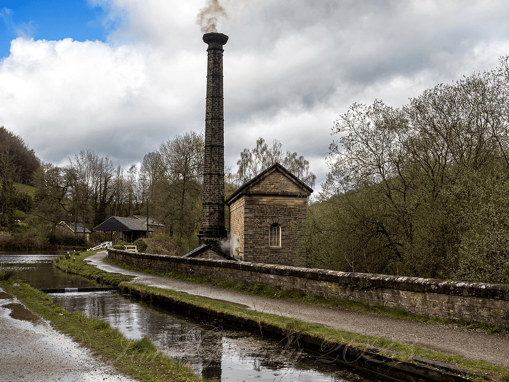
Building the canal with nothing more advanced than shovels and wheelbarrows seems remarkable today, especially as aqueducts were needed to cross the Derwent by the Leawood pump house and over the Amber (above – the railway came later!). In addition, Butterley tunnel, about 3,000 yards long, proved difficult to cut and maintain. The entire route from Cromford to the Butterley tunnel was on a level, so no locks were needed. This saved water, which was always an issue given the original supply was the Bonsall Brook, shared with Arkwright’s mill. The pump house was a later addition, lifting water from the Derwent. The estimate for the canal’s construction was about £42,000, but inevitably the actual cost was nearly twice this when it finally opened in 1794.

The staff of Wheatcroft’s office at Cromford Wharf

The sign in the photo gives a good idea of the goods carried by the canal: not just coal and coke but also salt, pipes and straw. However, by the time this was taken the canal was in decline: from the 1850s the railway was providing a cheaper and faster service. At its peak in the early 1800s the canal carried 300,000 tons per year, and paid shareholders a whopping 20%. But in 1852, as profits declined, the canal was sold to its railway rival – which was already operating the High Peak line from Cromford to Manchester. The tunnel suffered several rock falls, which finally closed the through route in 1900, though local traffic between Hartsay and Cromford continued until 1944. It seems curious that such a substantial, splendid piece of engineering should have such a short life, effectively becoming redundant after only 50 years!

Millstoned

If you go down to the woods today …

The stone I found in my local woods recently is typical of the thousand-odd millstones scattered around the Peak District – and are used as a symbol for the National Park. Clearly fashioned from the gritstone of the ‘edge’ behind me, this example raises some intriguing questions: who made it? why was it abandoned? how was it transported?

On Stanage Edge

Both wind and water mills used pairs of millstones to grind grain between them; the stones were about 1.8 metres wide and each weighed nearly 2.5 tons. Millstone grit from North Derbyshire was considered the best material for these, and in the late seventeenth century a pair would cost about nine or ten pounds, reflecting the skill and effort required to make them. Most production seems to have been small-scale; perhaps providing winter work for farmers, and may have been concentrated in the Hathersage area and along the ‘edges’, but there is also documentary evidence of manufacture at Alderwasley, Crich and Holloway. However, in the eighteenth century, with rising standards of living, demand for white flour increased and milling this needed finer chert millstones. Quite suddenly, the traditional stones were unwanted, and this may account for the numbers that were abandoned – although some may have cracked or had other defects.

Keep them rolling …

One minor mystery is how such heavy, valuable objects were transported, given that they were sold all over England and exported to the Continent. The sites of the quarries were often remote from the nearest road, so they may have been rolled in pairs, fitted with a wooden axle, until they could be craned onto a cart. In 1676 a miller at North Elmshall paid seven shillings and sixpence for carrying his new stones 22 miles. At Baslow there were complaints about loads of millstones weakening the bridge over the Derwent, and fines for offenders, which suggests fairly heavy traffic. As with lead, Bawtry was the main inland port for shipping millstones, both for export and to other English regions. But perhaps the biggest mystery is how the semi-amateur masons were able to produce such precisely cut stones with the crudest of tools.

Completing fishermen

The elegant Mr Cotton

Charles Cotton (1630-1687) was the owner of (the now demolished) Beresford Hall in Beresford Dale, on the upper reaches of the River Dove. As a Royalist sympathiser he found it prudent to live quietly in the country after the Parliamentary victory, but he was also a notable writer who wrote poetry in praise of the Peak District, as well as a best-selling handbook on games. But today he is mainly remembered as a fishing enthusiast who built a fishing ‘temple’ in his grounds on the Staffordshire side of the river. This still stands, on private land but visible from the footpath on the Derbyshire side. Over the doorway the initials CC and IW are intertwined, commemorating his friendship with Izaak Walton.

The fishing temple

Walton (1593-1683) was born into an innkeeper’s family in Stafford but seems to have been socially mobile, moving to open a linen draper’s business in London and becoming friendly with the local vicar, John Donne. But he was also a committed Royalist, and retired to Staffordshire after the War, where he bought land. His political leanings may have cemented his friendship with Cotton, but angling was probably the main tie, and Walton’s most famous work was The Compleat Angler (1653), to which Cotton later added some chapters. This book has gone through scores of editions in the past 370 years, yet is frankly almost unreadable today. Walton, who was 37 years older than Cotton, must have been good company, for he spent the last half of his long life staying with friends, and in some cases writing their biographies, including George Herbert and Richard Hooker.

Izaak on the job

In Cotton’s part of The Compleat Angler he describes a journey from Asbourne north to Milldale, in the form of a dialogue between a traveller (Viator) and a fisherman (Piscator), which emphasises the horrors of Derbyshire roads – this is the descent into the Dale:

Viator: It is as steep as a penthouse.

Piscator: To look down from hence it appears so, but the path winds and turns, and will not be found so troublesome.

Viator: Theses stones are so slippery I cannot stand. What’s here, a bridge? Do you travel in wheelbarrows in this country? This bridge was made for nothing else – ’tis not two fingers broad.

Piscator: I have rid over the bridge many a dark night.

Today the bridge at Milldale is still called Viator’s Bridge.

The Tunnel Road

Butterley and Ripley from Sanderson’s map of 1835

The Butterley Tunnel, shown on the map above, was one of the biggest engineering challenges in the construction of the 14 mile-long Cromford Canal, opened in 1794. Just over 3,000 yards (1.75 miles) long, the tunnel was only eight or nine feet wide, for reasons of economy. Clearly this did not allow space for a tow-path, and so the horses had to be walked over the hill, on the Tunnel Road which can be seen near the centre of the map. To avoid underground collisions there were strict rules for using the tunnel in different directions, for example barges travelling west could only enter the tunnel between five and six in the morning or one and two in the afternoon. They were expected to clear the tunnel in at least three hours. As the barges had to be ‘legged’ through, with the bargees lying on their backs, you can only hope they didn’t suffer from claustrophobia! The view of the eastern tunnel mouth today, below, gives an indication of how narrow the opening was, although when in use it would have been deeper than this photo sugests.

The Butterley Ironworks, a major factor in the growth of Ripley in the nineteenth century, was founded at the same time as the Canal was developed. Coal was mined from several pits in the area and iron ore was also quarried locally. The company went on to develop forges and blast furnaces at Butterley and Codnor Park. Clearly the canal was vital for the business, carrying both coal and finished products: an underground wharf still exists so that boats could be loaded directly below the Ironworks. One iconic product from Butterley was the steel frame of the roof of St Pancras Station.

At the end of the nineteenth century the tunnel suffered from mining subsidence, with rock falls, and was finally closed to traffic in 1900, so that the Cromford Canal, already suffering from railway competition, was cut in half. Today the Tunnel Road can be walked from the back of the Ripley Police HQ to Golden Valley, and several brick air shafts can be seen on the route. A path to the north of this road leads to the Britain Pit (photo above), whose winding wheel and engine house give an indication of the industrial past of the area. Sunk in 1827, this shaft is now part of the museum of the Midland Railway Centre, which operates trains on both standard and narrow gauge tracks nearby.

The ferryman at Anchor?

Anchor Church today

On the steep south bank of the River Trent, a short walk from Ingleby village, this rock-cut structure may have been used since the ninth century. Although the photo suggests that the river comes to the doorstep, in fact this is a pond, probably a remnant of an earlier course of the river, which has now shifted into a new channel to the north. Clearly cut out of sandstone, it is now thought that this was the refuge of the Saxon saint Hardulph, who had been deposed as King of Northumbria in 806 CE. He was buried at the nearby church of Breedon on the Hill, which is dedicated to him.

An interior view

The next stage in its history began in the thirteenth century, when it was the cell of an anchorite or hermit, hence the name Anchor. It is a mistake to imagine a hermit as a wild and solitary figure, leading a life of lonely meditation, and shunning contact with the world. Repton church and priory was quite near and may have been linked to the hermitage. It is also possible that the hermit was a part-time ferryman, at a time when the Trent ran at the foot of the rock. Burdett’s map of 1767 shows two ferry crossings nearby and upstream, one at Twyford and the other at Willington. Ferries were clearly quite common up to the nineteenth century, as a simple alternative to a costly bridge. Not only would this have given the hermit a useful function, but it could also have provided a small income.

An eighteenth century idyll

The hermitage presumably fell out of use with the dissolution of the monasteries in 1538, and the next records are from the eighteenth century when the landowners, the Burdett family of Foremark Hall, modified the structure for use as a summerhouse. This provided a suitably Gothic atmosphere for elegant alfresco parties, as can be seen in the print above. Sir Francis Burdett was a notable Radical who was actually briefly imprisoned in the Tower of London for libelling the House of Commons. Today the site is Grade II listed, and can be visited by footpath from Ingleby.

The hermit of the bridge

The causeway in the old days

Swarkeston Bridge was once the only crossing of the Trent between Burton and Nottingham, carrying traffic on the north-south route through the Midlands to Derby and beyond. At this point the river flows through low-lying meadows which flood regularly, and so the road is carried across these on a causeway about three quarters of a mile long. Most of this is medieval, although the actual river bridge was rebuilt in 1801. The whole structure is a clear illustration of the importance of river crossings in the past, and the resources that were devoted to constructing them. In this case, the legend tells of two unmarried sisters who lived on the north bank, and during a flood watched helplessly as their lovers tried to cross the torrent on horseback, before being swept away. As a result they spent all their resources on building the causeway, thereby impoverishing themselves.

Less peaceful today

Even when wealthy donors funded a bridge, maintenance was a constant issue. The Church seems to have been responsible for most bridges, and consecrated a body of men called ‘bridge hermits’, who were given an adjacent chapel to live in and were responsible for collecting tolls to pay for repairs. There are records, for example, of the Bishop of Ely in 1493 appointing a Robert Mitchell to the post and giving him a special outfit to wear. Although the bridge chapel at Swarkeston has disappeared there was also a chapel of St James by Chesterfield Bridge, while ruins of a chapel remain by Cromford Bridge. The best surviving example is by St Mary’s Bridge in Derby, which until the nineteenth century was the only crossing of the Derwent in the town.

Bridge and chapel in 1835

A list of the tolls charged (pontage was the term) for Swarkestone Bridge in 1275 is evidence of the extraordinary variety of goods traded in the region in medieval times. Tolls ranged from a farthing to 6 pence a load, although pedestrians were apparently not charged. This is a short extract from the list, but one wonders how the bridge hermit could assess all these tolls:

  • Any load of grass, hay, brush or brushwood – a farthing
  • Any horse, mare, ox or cow – a farthing
  • Any skin of horse, mare ox or cow- a farthing
  • Any pipe of wine – a penny
  • 5 flitches of bacon, salted or dried – a farthing
  • A centena of skins of lambs, goats, hares, squirrels, foxes or cats – a halfpenny
  • Every quarter of salt – a farthing
  • Every pack saddle load of cloth – three pence
  • Every sumpter load of sea fish – a farthing
  • Every load of brushwood or charcoal – a farthing
  • Every burden of ale – a farthing

Baslow and beyond

East end of Baslow old bridge

Driving on the busy A623 through Baslow today, it is easy to miss the medieval bridge next to St Anne’s church. Yet this was part of an important route in the eighteenth century: carrying the turnpike from Monsal Head to Chesterfield, while before then it carried packhorse traffic heading for East Moor and Sheffield. In 1500 an order was issued forbidding the carriage of millstones over the bridge; presumably their weight was damaging the earliest structure (which may have been wooden at that date). The small stone hut at the end of the bridge is sometimes called a watchman’s shelter, but elsewhere it is presumed to be for a toll collector. However the entrance is so low it is hard to imagine how this would work, unless the job was given to a child!

Lady Well, Bar Road

The old route can be followed from the bridge by crossing the main road and following School Lane uphill. This takes you through the heart of the old village but then continues more steeply uphill as Bar Road. Although this name may suggest a barrier or turnpike, according to Dodd and Dodd (1974) Bar was a name widely given to tracks that led down from the moors. Rather confusingly, Burdett’s map of 1762 tautologically names the river that flows through Baslow into the Derwent ‘River Barbrook’. Higher up Bar Road, beyond the houses, is the Lady Well, providing a welcome drink for travellers and their animals before climbing the last stretch up onto the moor. Once on the top, various landmarks such as the Eagle Stone and the Wellington Monument provide guidance.

Painting of the old bridge

Rain

Sir George Crewe of Calke with son John

It’s easy to assume that every extreme weather event – heatwave, drought or flood – must be the product of global warming. However, the storm that hit Derbyshire almost exactly 192 years ago, on the 26th of June 1830, could hardly have been caused by this. The event is recorded in the diary of Sir George Crewe of Calke Abbey, who describes how at 11.30 in the evening:

‘…the rain began to fall in torrents – I might say to descend in one sheet of water. Such rain I never heard before … Thus it continued, I should think, for at least an hour and a half‘.

Calke Abbey

In the morning Sir George went downstairs and found that the house had been flooded overnight through the front door, with red mud all over the carpets. Outside the lawns were covered in mud and the drive had been swept clear, down to its foundations. As a magistrate he had to drive to the Petty Sessions in Ashby that morning, and he records the difficulty of getting there due to the washed-out state of the roads.

A nineteenth-century view of Swarkestone Bridge

His diary records that on July 13th he had to attend the Quarter Sessions in Chesterfield – a substantial journey on horseback of about 45 miles (he must have had to stay overnight). The route would have taken him over the ancient Swarkestone Bridge, which had fortunately survived the torrents. At the Sessions he was told that the county needed £7,000 for bridge repairs as a result of the downpour – in modern terms, nearly a million pounds. No less than six bridges on the Amber alone had been swept away. Clearly, even the best turnpike roads at this time were unsealed, and so liable to be washed out in the event of severe rain.

Bridge building

Below Matlock bridge

In the current dry weather it’s quite easy to climb down and inspect the underside of the arches of Matlock bridge, a structure thought to date from the fifteenth century. As can be seen in the photo, this reveals a clear joint between the original structure and the widening carried out in 1904, which allowed two-way traffic on the bridge (since reduced to one-way in the latest traffic scheme). This is a reminder that most pre-twentieth century bridges would have only been wide enough for one cart or coach at a time, as is still the case with One-Arch Bridge at Chatsworth.

Holme Bridge north of Bakewell

Some were still narrower, such as Holme Bridge, on the River Wye upstream of Bakewell; just wide enough for a train of packhorses to cross. This is a reminder that bridge building was high skilled and thus expensive, yet bridges were absolutely critical to the transport network. The earliest bridges probably had a wooden superstructure resting on stone piers: easier to construct but liable to be washed away in any flood. All-stone bridges, with arches and breakwaters to deflect floating debris, were commonly constructed from the twelfth century but their cost was often met by a local monastery or abbey. In addition, tolls were frequently charged to pay for their upkeep.

St Mary’s bridge chapel, Derby

Important river crossing often had chapels attached, as with St Mary’s bridge in Derby (the only bridge in medieval times) or Cromford bridge (now ruined). The chapels would have provided a shrine for travellers to pray for a safe onward journey, and doubtless to leave an offering for bridge maintenance.

Bridge over River Bradford at Youlgrave

With most ancient bridges, establishing a date is almost as difficult as dating a road. The example above, with its simple round arch, and too narrow for a cart, could be anything from a hundred and fifty to a thousand years old, and would probably have been repaired many times after especially violent floods.

The lost fords of the Derwent – 2

Savepenny Lane looking towards Duffield on the opposite bank

The road layout south of Belper has changed hugely in the past 230 years. Before the Strutts built Milford bridge in about 1790 there were no bridges between Belper bridge and Duffield bridge. Milford was only a hamlet, and its name was originally ‘Muleford’, but with the growth of industry a better all-weather crossing was needed, as well as the construction of the impressive weir. Downstream the Derwent was forded at a point near the current railway station, as shown on Burdett’s map of 1791, and then near the church Duffield bridge is thought to have been built as early as the thirteenth century. In the eighteenth century this crossing was part of the Derby-Chesterfield-Sheffield turnpike route, and so would have been quite busy.

Burdett’s map showing river crossings near Duffield

The Duffield ford must have been more convenient for villagers, especially those going to Makeney or Belper, as well as for drovers moving cattle. In the eighteeenth century and earlier Makeney was a more important settlement than Milford, and it lay on the route of the Portway, which is thought to have crossed the Derwent nearby. The Holly Bush Inn claims to be one of the oldest in the county, and may have served long-distance travellers as well as locals. It may be significant that a holly bush is one of the earliest inn signs, as in the saying ‘A good wine needs no bush’.

The Holly Bush at Makeney

The route from Makeney to Duffield via the ford was once known as Savepenny Lane, since it allowed users to avoid paying the toll which the Strutts charged on their new bridge. However, this route was blocked by the Strutts; deepening the river at that point and blocking the lane on the west bank. The curious result is that today the lane still exists on the east bank, and in fact has recently been confirmed as a BOAT (byway open to all traffic), although it is a cul de sac. An ideal stroll, perhaps, before moving on to a lunchtime pint at the Holly Bush?