Going round in circles?

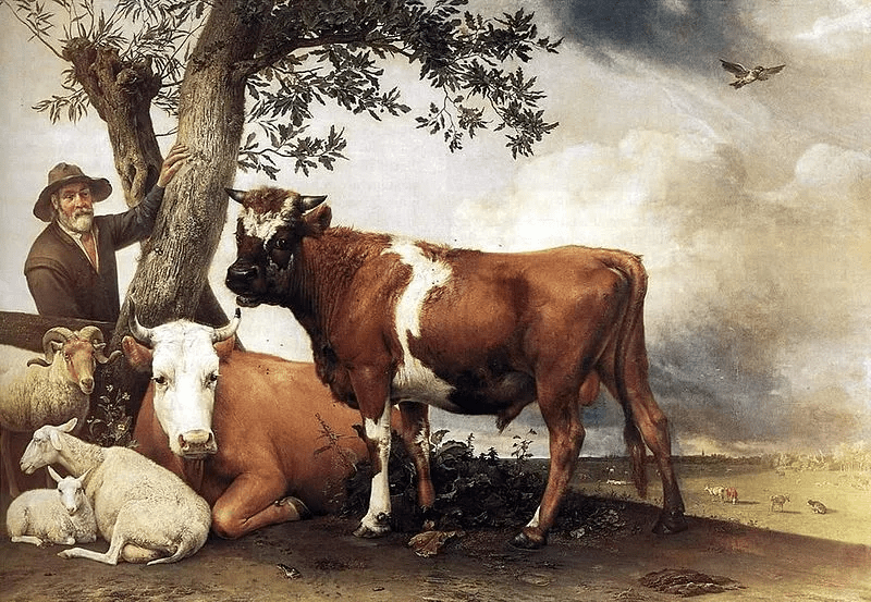
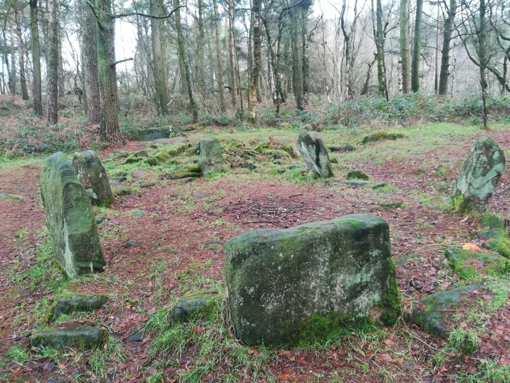
Doll Tor, near Birchover

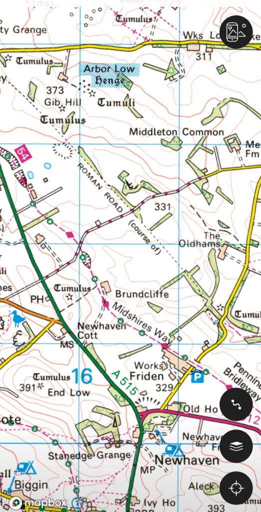
There are over a thousand stone circles in Britain and France, and Derbyshire has its share, ranging in size from Arbor Low (up to 50 metres in diameter) to much smaller versions, such as Doll Tor (above). This latter is part of a cluster of circles, with the Nine Ladies on Stanton Moor close by, and Nine Stones Close on Harthill Moor not far off. There may have been more circles in the past, since we have evidence that some have been pillaged for their stone (Nine Stones actually only has four stones), and others destroyed as pagan symbols by God-fearing landowners. Most of the surviving circles are on moorland or high pastures, which raises the question whether the reason for their survival was their location on land of little value. Others might argue that the circles were built on high places for astronomical purposes, to observe sunrises for instance. In fact, although the circles have been studied, measured, excavated and theorised about for over two hundred years, we still seem no closer to knowing their purpose

Nine Stones (in theory) Close on Harthill Moor

There does seem to be agreement that most circles belong to the Bronze Age, roughly 3,000 years ago, though obviously dating such basic structures is not easy. But over this time span many may have been altered, so there’s no guarantee we’re looking at the original layout. Some of the stones at Doll Tor, for example, have been re-set, and Bateman records seven stones on Harthill Moor in the nineteenth century (others claim that these stones have been raised to standing position, it being the only circle in the county with standing stones).

Nine Ladies Circle on Stanton Moor

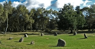
Some circles seem deeply unimpressive: The well-known Nine Ladies, for instance, hardly compares with the majesty of Stonehenge. Yet, large or small, there is still no clarity on why these monuments were built. Vague talk of ceremonial sites or astronomical observation is pure speculation and seems as dubious as Victorian ideas of ‘druidical temples’. Perhaps there is a simpler explanation. Before the Romans arrived the British lived in round, wooden houses – effectively the only shape of building they made. A stone circle can be seen as a symbol – a permanent representation – of their house, which proclaimed ownership of the land to all travellers and passers-by. The circle would be a permanent claim to their property, in days before the Land Registry. Both Arbor Low and Nine Stones are on prehistoric routes (the Street and the Portway), but other circles would have been visible from the tracks across the uplands.

Druids doing their thing

On getting lost

No danger of getting lost here

It’s difficult to get lost today. Google maps will display every street in the city, and spell out your quickest route, while in the country apps such as OS Maps will tell you exactly where on the path you are standing. The appeal of this technology is obvious – not just saving time, but also removing the fear that you’re heading the wrong way, into the unknown. In Derbyshire and the Peak District, with thousands of miles of footpaths, this reluctance to risk being lost results in crowds of visitors heading for the same honeypots such as Dovedale, Mam Tor, or the Cromford Canal, with predictable results.

The delights of a day in the country

It has been argued that the experience of getting lost can be valuable for our development, and we can cope better with that fear if we develop a strong sense of direction. Moreover, research has shown that the more children are allowed to roam freely, the better sense of direction they acquire. Although there must be marked individual variation, it seems that children today are restricted to a much small radius of ‘free movement’ – perhaps a few hundred yards – instead of the miles that children wandered away from home in previous generations. Of course, it can be argued that there is good reason for the restriction, but if children are barely allowed out of sight of their home they have little possibility of feeling lost – and then finding their way back.

Call Social Services?

How do we get a sense of direction? Moving through a landscape we notice and memorise a series of landmarks, while the position of the sun should provide an additional bearing (provided it’s at least partly visible). To return, the landmarks are revisited. The second time you make the journey, the landmarks are stored in your memory, even after a gap of months or years, as most walkers have found. Our nomadic ancestors, travelling through an unmapped countryside thousands of years ago, must have achieved an advanced ability to find their way, using perceptions unknown to us.

Reading the stone

The stone in the north wall of St Mary’s, Wirksworth

The Wirksworth Stone must be one of the most remarkable examples of sculpture from the Saxon era in England. Discovered in 1820 face down, buried under the church floor, it is thought to have been the lid of a sarcophagus belonging to an early saint, possibly Betti. It dates from about 700 CE, and displays a sophisticated iconography which reveals a strong Eastern influence e.g. the use of the Greek cross with equal arms. Perhaps the most interesting question is who produced this work 1,300 years ago, and was it carried here or made on the spot?

St Mary’s in its oval churchyard

Clearly the present thirteenth-century building (above) was not the first on this site; in fact the name of the local river, Ecclesbourne, suggest a very ancient foundation, probably a minster church for the whole wapentake of Wirksworth. Just as churches were built by travelling stone masons we can assume that sculpture like this was the work of itinerant artists, who would also produce crosses like those at Bradbourne and Eyam. It is claimed that the Wirksworth stone shows the work of two masons, the one responsible for the lower half being more skilled than his (or her) workmate. Although overall the workmanship is somewhat crude, the scenes portrayed cover the whole range of Christian teaching.

The ascent of Christ, in mandala (detail)

The left hand side of the stone has been broken off, so originally there were ten scenes but now only eight are visible. It appears that the stone should be read vertically, top to bottom, rather than left to right like a modern comic strip. So the top left scene shows Christ washing the feet of the disciples, and the one below the Harrowing of Hell, when the crucified Christ is supposed to have descended into Hades. The next pair are clearly the Crucifixion (with four evangelists) paired with the Ascension below. The third scene on the top represents the death of the Virgin, and below this the Annunciation is shown, with Mary seated. The final scene on top is the Presentation of the infant Christ in the temple, and under this the disciples prepare for their preaching mission (note the figure in the boat). Overall, and assuming the missing section showed the Nativity and the Baptism of Christ, the whole panel presents a remarkable statement of fundamental Christian beliefs. The position of Wirksworth on the Derbyshire Portway reinforces the theory that this was the work of travelling craftsmen, bringing the essentials of their religion in pictorial form to the (presumably) illiterate of the Peak.

The ridgeway rumpus

The road(s) to Buxton

The OS map of the area north of Newhaven shows how popular this route has been for transport: the modern A515 follows the line of the eighteenth-century turnpike; the Midshires Way runs along the route of the Cromford and High Peak Railway, while the Roman road (The Street) runs a little to the east of this. All of these are following the high ridge between Newhaven and Buxton, avoiding the valleys on either side. It seems a classic example of a ridgeway, which have been generally seen as long-distance travel routes, with well-known examples in the south of England such as the Icknield Way, running south west from Norfolk towards Avebury, the western section now simply called ‘The Ridgeway’.

Walking the Ridgeway

It is suggested that ridgeway routes were developed in prehistoric times for long-distance travel, since their route involved fewer descents into boggy river valleys, while higher ground was less densely wooded and gave travelers a better view of landmarks ahead. Moreover, there seem to be many prehistoric remains such as hillforts or tumuli near these routes, further justifying their existence. In many cases the Romans seem to have taken over these routes and engineered them to their standards. However, other prehistorians claim that the ridgeways which have survived owe their survival to being in remote upland areas, and that modern aerial photography shows evidence of wide prehistoric settlement, not only on the higher ground. Some also argue that there is no evidence that the ridgeways are prehistoric, and may well be medieval.

Minninglow, visible for miles around

In view of this debate it is worth looking at the line of the Roman road from Brassington to Buxton, part of which is shown on the map above. Not only are there many tumuli along the way – ancient burial mounds – but also a large number of ‘lows’: Slipper Low, Minninglow, Aleck Low, Arbor Low, Great Low, Brierlow and others. ‘Low’ is derived from Anglo-Saxon ‘hlaw’ meaning (confusingly) ‘high place’, and again was the site of burials, as can be seen at Minninglow. Added to the proximity of the Arbor Low henge – one of the largest in England – the evidence for a prehistoric date for this route appears convincing.

NB: Today there are hardly any rights of way along the Roman road, but the route can be roughly followed from the High Peak Trail.

Four legs good?

Cave painting of hunter and dog c.10,000 BCE

Dogs were the first animals to be domesticated, apparently during the last ice age, about 15 or 20,000 years ago. Hunters may have shared their kill with young wolves, who became camp followers and provided some services in return. Dogs could be trained to help the hunters by retrieving game, as well as guarding their campsites. Travellers soon found that dogs made useful companions on a trek, especially if they were herding animals such as cattle or sheep. As cities grew in the eighteenth century and the demand for fresh meat rose, drovers and their dogs walked the cows from the upland districts in the north and west to the butchers of Sheffield or Nottingham.

On a packhorse trail in North America

Perhaps even more significant was the domestication of the horse, thought to have occurred about 5,000 years ago, in the early Bronze Age, near the eastern borders of Europe. Evidence for this are the elements of horse harness such as bits and bridles found in grave burials around 2,000 BCE. For the next four thousand years horses provided the fastest travel on the planet, as well as weapons of war (cavalry and chariots) and transport of goods (either as packhorses or pulling carts). Over long distances a rider could average about four miles an hour, so about 30 miles was a good daily total for both rider and horse, with about seven hours in the saddle. It seems remarkable that just 200 years ago our entire economy was based on horse power, from agriculture to personal mobility to powering the first railways!

Today’s walkers in Derbyshire are likely to be concerned about crossing fields with cows grazing, especially if they have dogs with them. Although the number of deaths caused by stampeding animals is small, it is a real risk, and most hikers have had uncomfortable experiences, if not worse. Although likely to be an underestimate, the HSE keeps records of injuries from cattle, and between 2000 and 2020 98 people were killed by them: many more were presumably injured. Of these the majority (76) were farm workers, and the rest were walkers. The general consensus is that bullocks represent a greater danger than the odd bull, and that cows with calves should be given a particularly wide berth. Carrying a stick probably makes the walker feel better, and dogs should be let off their leads to escape quickly if a situation feel threatening.

Hemlocked

The Hemlock Stone

The Hemlock Stone on Stapleford Hill west of Nottingham is a sandstone pillar about five metres high, set in parkland. The name suggests that it may have acted as a boundary marker between Derbyshire and Nottinghamshire, and it is found near the Portway’s crossing of the Erewash (the county boundary). It seems to have had more significance in the past, with eighteenth-century references to its use for Beltane celebrations, and was famous enough for DH Lawrence to include it in Sons and Lovers as the destination for an Easter walk.

A barefoot Lawrence at the University of Nottingham

The walk from Eastwood to the Hemlock Stone had actually taken place in 1905, organised by Lawrence for his family and friends. Beginning in the town, the original route is now difficult to follow due to the construction of the A610 on the line of the old railway, but the walking party first crossed the semi-derelict Nottingham Canal, then the Erewash, and thirdly the Erewash Canal, soon coming to a footbridge over the Midland mainline railway, whose express trains linked Eastwood and Langley Mill to London. The party next joined the Heanor-Ilkeston road and followed this through Ilkeston, a town Lawrence knew from his teacher training. Their route then turned towards Stapleford: today mostly built up but following pleasant country lanes a hundred years ago. It is interesting that the Stone was seen as a significant destination, worth a fourteen-mile walk (at least), and was clearly a popular spot:

‘Everywhere in the field below, factory girls and lads were eating lunch or sporting about’.

Jessie Chambers, the model for Miriam Leivers

In the novel the importance of this walk is the emerging love between the hero, Paul Morel, and Miriam, the girl from Haggs Farm (a thinly-disguised Lawrence and Jessie Chambers). Both felt rather alienated from the rest of the party, who were inclined to climb the Stone and carve their names there. On the way home they both fell behind the others, Lawrence struggling to repair an umbrella, and their mutual sympathy developed into a complicated affair which dominates the first half of Sons and Lovers and has become a classic of teenage angst.

Reinventing the wheel?

The wheel is often cited as a critical invention in the development of our civilisation, and today wheels are so abundant it is difficult to imagine life without them. Yet they arrived in Britain relatively late – Stonehenge was built by a wheel-less society. The earliest wheel found so far, in Flagg Fen in Cambridgeshire, dates from about 1,600 BCE and is a solid wooden disc. The wheel above, from a museum in Avila, Spain, is over 3,000 years newer, and illustrates the complexity of making wheels almost without metal. It consists of five curved wooden sections, reinforced by a rim of five narrower pieces, all held together by ten spokes radiating out from a wooden hub strengthened by iron bands. Clearly the use of spokes makes for a much lighter wheel, reducing the effort for the carthorse.

These iron wheel rims were found in a chariot burial in northern Greece. They are thought to be Thracian, dating from the Roman period, and, remarkably, the skeletons of two horses were found in the tomb, buried in a standing position. The wooden part of the wheel has disappeared, but traces left in the soil show that it had spokes. Similar chariot burials have been found in Britain, notably in East Yorkshire, where a site at Pocklington in 2018 yielded the remains of a high-status burial of a chariot, thought to belong to the Iron Age (roughly contemporary with the Greek tomb), containing a man’s skeleton, along with the bones of two horses.

Wheeled vehicles such as carts, waggons and coaches were historically less common in north Derbyshire, due to the steep, poor roads and use of packhorses. However, for working lowland farms and for market journeys carts were more efficient than packhorses, needing only one horse to carry a ton of goods. With the improvements in road surfacing brought about by turnpike roads in the second half of the eighteenth century, all major Derbyshire towns were connected by regular coach services by the early nineteenth century. The picture above shows a passenger-carrying brake or charabanc outside the Sun Inn at Buxton, perhaps waiting for a tourist party to finish their lunch?

Salt

Saltways in central and northern Derbyshire (Dodd & Dodd, 1980)

Today salt is cheap and easily available, so it’s easy to overlook its vital importance in the past. It was critical for the agricultural economy, since before freezers were available it was used to preserve the meat that had to be stored over the winter, owing to the lack of winter feed. But in addition to preserving meat (and fish) salt was essential for baking bread (a large proportion of the common diet) as well as flavouring many dishes. From the seventeenth century salt was also used in the Midlands to produce salt -glazed pottery, in which salt was added to the kiln to create an attractive finish.

19th century Derbyshire salt-glazed coffeepot

In the past salt was produced by evaporating coastal salt pans, or by mining rock salt. The nearest source to Derbyshire were the Cheshire ‘wiches’: Northwich, Middlewich and Nantwich, and routes, often called saltways, led east from there to towns such as Sheffield and Chesterfield. Using the plentiful ‘salt’ road names such as Saltersford and Salterslane historians such as David Hey have tried to reconstruct the routes the packhorse trains would have taken. Clearly these tracks would have been used for carriage of other goods, but demand for salt, especially in autumn when livestock had to be salted for winter, must have ensured a fairly regular salt trade. The journey from Cheshire to Chesterfield, where Saltersgate is one of the main streets, leading to the medieval market place, must have taken about three days.

Salt mining in 19th century Cheshire

Salt production and transport has also left a mark on the map of Europe. Salzburg was a major centre, and from there the ‘golden route’ went north east into Bohemia. In Roman times the Via Salaria ran from the Adriatic coast to Rome (but the often-repeated claim that Roman soldiers were paid in salt, hence the word ‘salary’, is false, as common sense should tell us!).

Sources:

Hey, D. Packmen, Carriers and Packhorse Roads (2004)

Dodd, AE & Dodd, EM Peakland Roads and Trackways (1980)

http://kiwihellenist.blogspot.com/2017/01/salt-and-salary.html

Bilberry crumble?

View of presumed stone circle on Bilberry Knoll

Writers of Matlock tourist guides in the nineteenth century described megalithic remains on Riber Hill, above Starkholmes, which are variously labelled dolmen, cromlech and rocking stone, and appear to have been four large stones, one balanced on another. But there was no trace of these a hundred years ago, and they appear to have been broken up, possibly on John Smedley’s orders, as idolatrous pagan survivals. It is easy to forget the role played by religious fanatics in destroying such remains.

However, there seems to have been a stone circle nearby, on the top of Bilberry Knoll, beside Hearthstone Lane, less than a mile south of Riber Castle. This site was explored by a John Simpson around 1905 and described in an article in the Derbyshire Archaeological Journal for 1915. He thought that such circles were evidence of prehistoric sun worship, and claimed that this circle aligned with the Nine Ladies circle on Stanton Moor at sunset on the Summer Solstice. Regrettably he did not draw a plan of the site, or include any useful photos, but estimated that the circle had a diameter of 144 feet.

The start of the path down through the beeches to Cromford

Today the site is remarkable for the jumble of stones in one area, although it is difficult to make out the shape of a circle. Some stones may have been broken up for walling. But whatever we may think of Simpson’s theories, two things are clear. Firstly, Bilberry Knoll is a remarkable viewpoint, ideally suited to some kind of monument, and secondly it is near the crossroads of two ancient tracks: Hearthstone Lane which runs from west to east, and another route which Simpson describes, coming from Lea Green, fording the Lea Brook and then climbing past Upper Lees farm to the ridge and down to Cromford bridge, Scarthin, Bonsall, Brightgate, joining the Portway to Robin Hood’s Stride and on to Youlgrave and possibly Arbor Low.

Field barns near Castletop, Hearthstone Lane above

Too much speculation, maybe, but Alison Uttley should have the last word. She was brought up in the late nineteenth century at Castletop farm, near the west end of Hearthstone Lane:

“… the old highway, dating from long before any of the roads in the valley. We knew, from family tradition, that the packhorses travelled along it, and that lead from the Roman mines in the hills was once carried on its winding slopes on ponies’ backs.”

Sources: Simpson, J. Megalithic Remains on Bilberry Knoll, Matlock. DAJ Vol 37, 1915

Uttley, A. Ambush of Young Days. Faber and Faber, 1937 p.107

Harboro’ highlife?

Harboro’ Rocks seen from the High Peak Trail

A couple of miles west of Wirksworth, just above the High Peak Trail, Harboro’ Rocks are a distinctive limestone outcrop rising to 379 metres. The summit offers a splendid view of Carsington Water to the south and the Via Gellia valley to the north, while providing practice pitches for climbers. The Rocks have been the subject of several archaeological digs, the latest reported in the Derbyshire Archaeological Journal (Makepeace 1990 and 2004). According to these, evidence was found of a Late Bronze Age or Early Iron Age settlement: pottery fragments, domestic animal bones, a flint tool and a button. There is also a remarkable cave in which Daniel Defoe found a lead-ming family living in 1720, and which clearly could have been occupied in prehistoric times.

Cave at Harboro’

However, this picture ignores three factors. First, why should anyone settle on such a bleak and elevated spot, with no source of water? The thesis also fails to mention that the Rocks are near the junction of two important ancient routes: The Street, which was engineered by the Romans over an older ridgeway and ran from Wirksworth to Buxton, and the Portway, which headed north from Harboro’ towards Mam Tor and beyond. Finally, the name ‘Harboro” goes back to at least c. 1200 CE and may mean ‘shelter’ or ‘fortified place’, according to Cameron (1959). What must be significant is that this name crops up on two other hilltops along the Portway’s route: Arbour Hill outside Dale and another Arbour Hill in Wollaton.

Burdett’s map of 1762 showing roads west of Wirksworth and position of the Rocks (arrowed)

So my suggestion is that this was not the site of a Bronze Age ‘settlement’, but could have been a fortified campsite for travellers on these two important routes. This would account for the sparse nature of the finds from the excavations – people were travelling light. Similar to the caravanserai found in the Middle East, these campsites seem to have been spaced every six or seven miles along the Portway and would have given the travellers some security for themselves and their animals when they stopped for the night. The next, going southeast, is Alport Height, and to the north, Cratcliffe Rocks.

Inns for travellers were part of the Roman road system, but I doubt whether any were provided in such a backward area as Derbyshire. We can only guess how these campsites were organised; whether locals sold water and provisions to travellers, and how they were maintained. However, there is enough evidence to suggest that these places provided vital protection for long-distance wayfarers until the growth of towns and the development of the modern inn during the medieval period.