The secrets of Shuckstone

The cross base, with dandelions, looking east

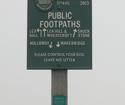
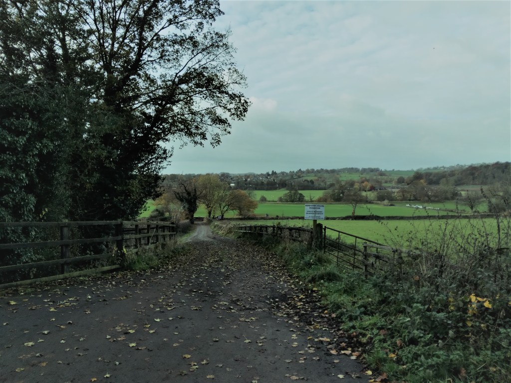
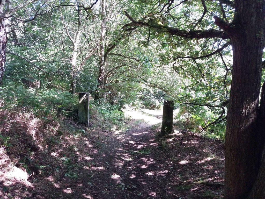
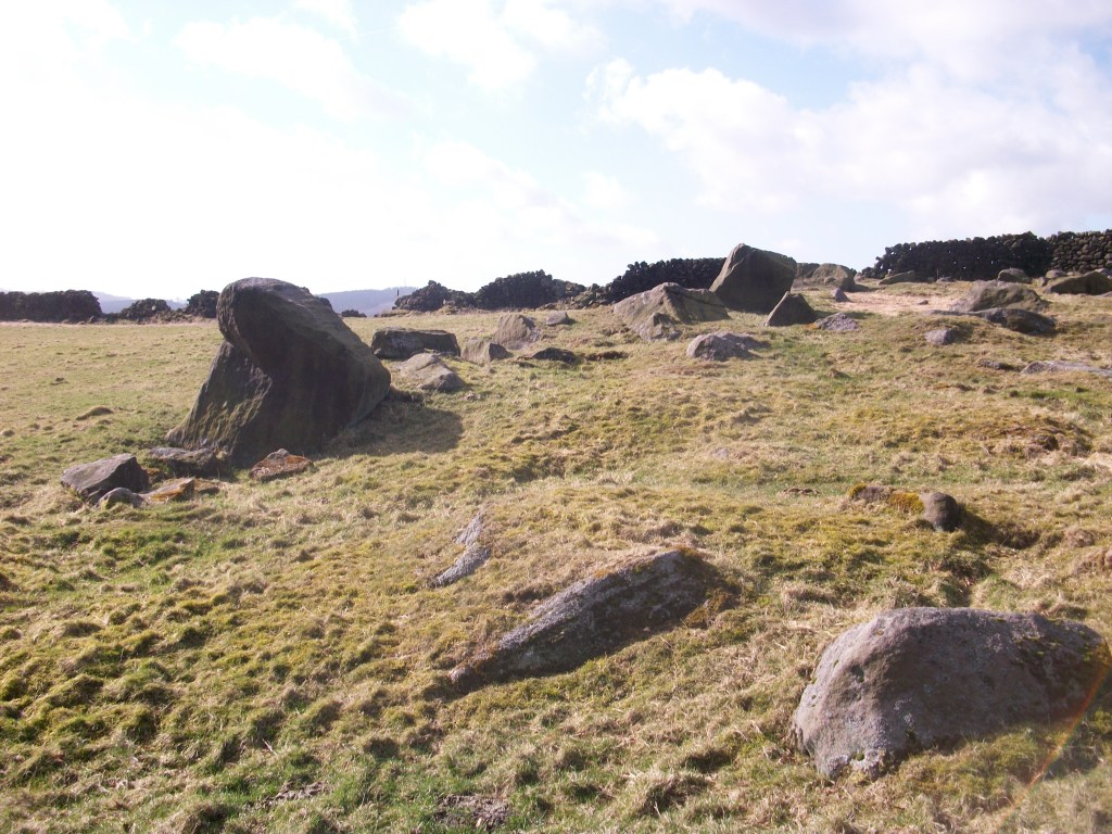
Starting from Whatstandwell Bridge, if you follow the track from the hamlet of Robin Hood up through the quarry and wood to Wakebridge, and then on past Wakebridge Farm up to the top of the hill, the route finally levels off and you come to Shuckstone Fields, behind Holly Grange Farm and above Lea. This large field contains the intersection of five footpaths, and Shuckstone Cross must have marked this point. Today only the base remains, and the markings on this are illegible, but according to local historian George Wrigglesworth the four sides were marked C (for Crich) A (possibly Ashover) M (Mansfield or Matlock) and W (Wirksworth). In the late eighteenth century a pot containing Roman coins was dug up here, presumably buried by someone wanting a clear marker for their savings. Not far away is a ‘Holy Well’ of three compartments, which could have offered refreshment for travellers.

The Holy Well

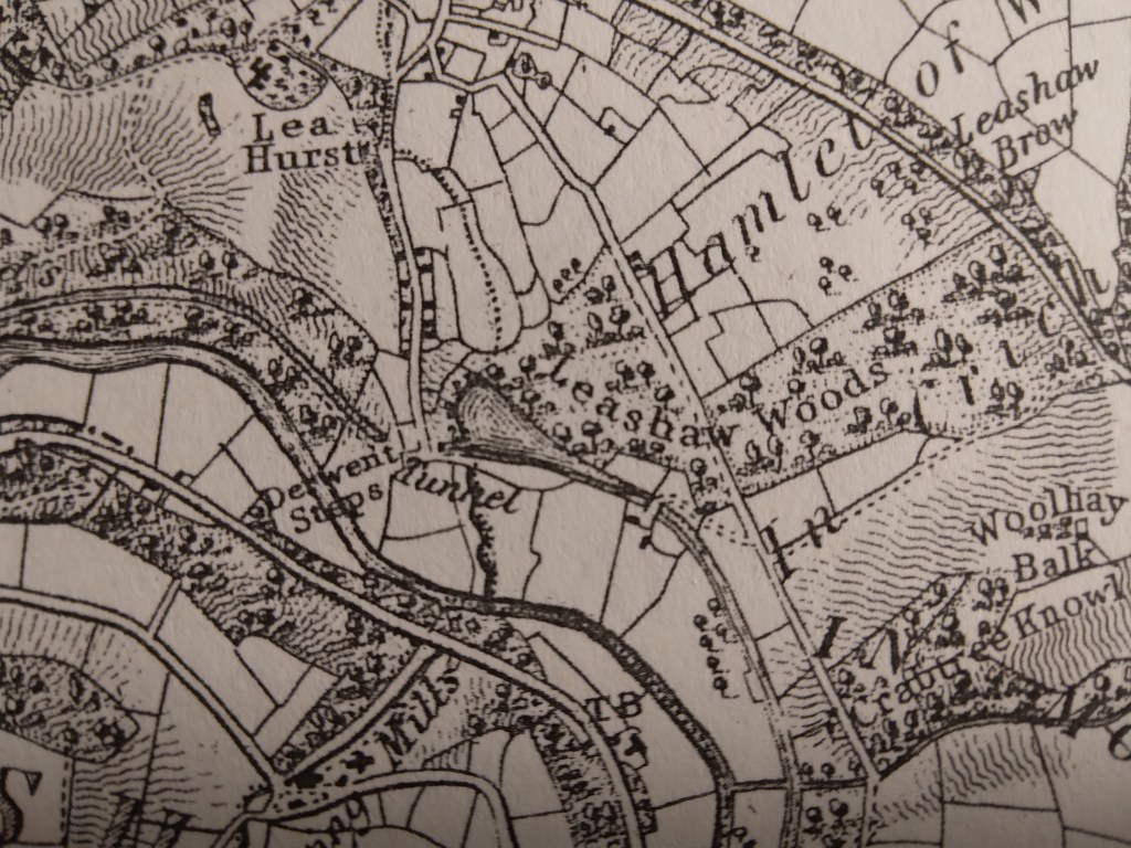
The term ‘cross’ can be misleading: the crosses found in country churchyards, as at Eyam, had a cross shape and were often preaching crosses, while a cross as at Shuckstone was simply a stone shaft held in a square base which acted as a waymark or signpost. This marker would have been clearly visible at this high point (nearly 900 feet), which was moorland until a couple of hundred years ago: the 1791 map shows that the area was the southern tip of East Moor, an expanse of rough pasture which stretched from here north towards Chatsworth and then Sheffield.

The Cross may have also been a boundary marker, since the same map (Burdett’s) also shows that the track up from the Derwent runs along the old wapentake boundary, with the wapentakes of Wirksworth to the west and Morleyston to the east. According to Kenneth Cameron, (The Place-names of Derbyshire Part 2) the name ‘Shuckstone’ is fairly recent, and older records, going back to the Domesday Book, refer to this spot as ‘Shuckthorn’ or similar, meaning the Devil’s thorn tree. This is certainly a location well worth visiting, but probably not on a dark night.

A choice of paths

The lost fords of the Derwent – 2

Savepenny Lane looking towards Duffield on the opposite bank

The road layout south of Belper has changed hugely in the past 230 years. Before the Strutts built Milford bridge in about 1790 there were no bridges between Belper bridge and Duffield bridge. Milford was only a hamlet, and its name was originally ‘Muleford’, but with the growth of industry a better all-weather crossing was needed, as well as the construction of the impressive weir. Downstream the Derwent was forded at a point near the current railway station, as shown on Burdett’s map of 1791, and then near the church Duffield bridge is thought to have been built as early as the thirteenth century. In the eighteenth century this crossing was part of the Derby-Chesterfield-Sheffield turnpike route, and so would have been quite busy.

Burdett’s map showing river crossings near Duffield

The Duffield ford must have been more convenient for villagers, especially those going to Makeney or Belper, as well as for drovers moving cattle. In the eighteeenth century and earlier Makeney was a more important settlement than Milford, and it lay on the route of the Portway, which is thought to have crossed the Derwent nearby. The Holly Bush Inn claims to be one of the oldest in the county, and may have served long-distance travellers as well as locals. It may be significant that a holly bush is one of the earliest inn signs, as in the saying ‘A good wine needs no bush’.

The Holly Bush at Makeney

The route from Makeney to Duffield via the ford was once known as Savepenny Lane, since it allowed users to avoid paying the toll which the Strutts charged on their new bridge. However, this route was blocked by the Strutts; deepening the river at that point and blocking the lane on the west bank. The curious result is that today the lane still exists on the east bank, and in fact has recently been confirmed as a BOAT (byway open to all traffic), although it is a cul de sac. An ideal stroll, perhaps, before moving on to a lunchtime pint at the Holly Bush?

The Darley Mystery

St Helen’s, Darley Churchtown

Darley Churchtown is a small part of the large village of Darley Dale. Today it is easily by-passed as it lies off the A6, although it was on the line of the old Matlock-Bakewell turnpike. It has several curiosities, all centred on the church of St Helen’s. The most obvious is right outside the church porch: a huge yew tree, over thirty feet in circumference, and claimed to be anything up to 2,000 years old (see: The Sacred Yew, Chetan and Brueton). Even if this early date is taken with a pinch of salt, it may well have been growing before the Conquest, and would pre-date the existing church (which has a Norman font). It is certainly the largest of all the Derbyshire yews; other notable examples grow at Allestree and Doveridge.

Yew tree in St Helen’s churchyard

If you walk from the churchyard heading south, then take a field path to the right you find yourself walking along a reed-fringed dike, heading for the cricket ground at Darley Bridge. This winding path is still a parish boundary, which suggests it may be the old course of the Derwent, which has since shifted more to the west. This would mean that the church site was virtually an island, with the river running right beside it: even with the Derwent in its present course the church has often been flooded. Yet this is not the only church in this valley built on flood-prone sites: Duffield is another. Could this be an example of the belief that island sites were sacred places? An alternative possibility is that in the early church the river was used for baptism.

Another oddity can be found by walking from St Helen’s in the opposite direction, along the track north towards Rowsley. Just past the school is Abbey House, a substantial Victorian building. The Ordnance Survey map from 1896 marks ‘Remains of Abbey’ at this point, yet according to historians there never was an abbey at Darley Dale. Confusingly, the local abbeys were at Darley, just north of Derby, and at Dale near Ockbrook. So what was the origin of the idea of a Darley Dale abbey?  Curiously, the exact site of Derby’s Darley Abbey has never been identified, though it is presumed to have been on the site of Darley Park. That abbey was linked to St Helen’s Priory in the town, which has the same dedication as is found at Darley Churchtown. Perhaps the safest assumption would be to say that the religious site at Darley appears to be very ancient, quite possibly Saxon, that it could have been a semi-artificial island, and may well pre-date the abbey at Derby.

The lost fords of the Derwent – 1

Railway bridge on Ladygate leading to Old Matlock

River crossings have always been critical points on the road network, and originally these would have been fords, passable for riders in normal conditions, and possibly having stepping stones for those on foot. From medieval times onwards fords on the Derwent were mainly replaced by stone bridges, though their location is still remembered by the place names Bamford, Grindleford, Cromford, Homesford and Milford (from north to south). The original name for Matlock appears to have been Mestesforde (i.e. in the Domesday Book), and many historians have assumed that this ford was near the site of the current bridge. But the nucleus of old Matlock is actually at Starkholmes, not near Crown Island, and so it has been argued that the ford was near the point where Ladygate Lane now crosses the river on a footbridge.

Well below St John’s Chapel

The westward route would have climbed up the hill, past the nineteenth century St John’s Chapel (built over a perpetual spring), and up to Bonsall, near where it linked up with Salters’ Way. The more modern route of Salters’ Lane, leading to Matlock Bridge, developed after this bridge was constructed, although the date of the original bridge is not clear. The access to the bridge on the east side was easy, but because this land (i.e. Hall Leys) flooded regularly (and still does) development may have continued around St Giles for some time.

The site of Homesford from Sanderson’s 1835 map

A few miles downstream, the Homesford Cottage pub (still advertised as selling Kimberley Ales) has become a guest house, and the name Homesford is not found on the OS map. Yet Sanderson’s map from 1835 shows a road from Upper Holloway running down past Lea Hurst (Florence Nightingale’s home) and over Gregory Tunnel on the Cromford Canal. The name ‘Derwent Steps’ by the river suggests a well-established set of stepping stones, with presumably a ford beside for carts and livestock. Today the Derwent can still be crossed here on a footbridge, suggesting that this was an ancient route, but there is no sign of any steps in the currently fast-flowing, turbulent river!.

Lea Road: A sorry, soggy story

Gateposts in Bow Wood show that this was more than a path

The tendency of Derbyshire roads, over time, has been a shift from high-level routes to more convenient ways in the valleys, with gentler gradients. A good example is the road from Cromford Bridge to Lea Bridge, which in medieval times ran past the site of Cromford Station and then turned uphill at Wood End, away from the Derwent, and ran past Castletop farm and through Bow Wood and down to the Lea Brook. This route can still be followed on foot, taking the path just past the railway bridge, up through the wood, and then joining the old track beyond the house.

However, when the Cromford Bridge and Langley Mill Turnpike Trust was established, an easier route was selected, following the river up to what is now High Peak Junction, and then turning north east to Lea Bridge, at that time quite an industrial complex. This new road went on to Holloway, Crich, Bull Bridge and Codnor Gate (where until recently the turnpike was commemorated by the Gate pub).

The road had a tendency to flood in very wet weather, especially near the Cromford railway bridge, but remained a useful route for over two hundred years. But following heavy rain in November 2019, the river had undercut the bank and part of the road collapsed in January 2020, causing the council to close the road the next day.

The road today

In the nearly two years since the road closure the residents of Lea Bridge and Holloway have had no direct access to Cromford or Matlock, and so have had to make lengthy detours on narrow lanes, such as the route over Riber hill. What they find most annoying is the lack of any sense of urgency in re-opening this critical route. Derbyshire County Council and their contractors, Eurovia, have produced a variety of excuses for the prolonged closure, claiming that there have been further landslips. Yet on a a warm dry autumnal day like today no-one is working on the site, while the road, for some reason, is even closed to walkers and cyclists.

They shall not pass

Given that the old turnpike road was engineered by men with wheelbarrows and picks, it seems incredible that today, with modern equipment, we are incapable of repairing a few hundred yards of road in less than two years.

The story of the lane

Hearthstone Lane near Castle Top farm

It is rare to find a historic written description of a Derbyshire road: most literate people in the past took the state of the roads for granted. Therefore it’s especially interesting to have an account of Hearthstone Lane, which runs north from Castle Top farm to Riber, and is today a bridle path. This was written by Alison Uttley, who was brought up at the farm in the late nineteenth century, in her memoir ‘Ambush of Young Days’. She says:

This latter was the old highway, dating from long before any of the roads in the valley. We knew, from family tradition, that the packhorses travelled along it, and that lead from the Roman mines in the hills was once carried down its winding slopes on ponies’ backs. It wandered up to the crest of the hills, cutting through some of our fields, and then it followed the high ridge, between two stone walls, with the land dropping on either side to two valleys. This hill road was grass-covered, and only horses and cows went along it in those days, with sometimes a countryman who was visiting us, the pig-killer, the mole-catcher, the hedger or the thatcher’.

Higher up Hearthstone Lane

Less than a mile from Castle Top farm is the site of an old cottage, easy to miss if you haven’t read Uttley: ‘The Boggart House was sinister, ghostly, and I crept up on tiptoes, although the grass in the lane hid all sound.There were stories about this cottage, which was said to be haunted. I had no fear of the ghost, but of one of the inhabitants. A man and his wife lived there, a good couple, living the most lonely life imaginable … But with them dwelt their son, who had had an accident in the quarries, long ago. He had two noses, it was said, and this is what alarmed me’. Today there are still gooseberry bushes growing in what was their garden, but it seems extraordinary that a family could have lived there, so remote even from a well.

The site of the Boggart House

The Lane is partly a ridgeway, as Uttley appreciated, and the highest point, before it drops down towards Riber, is called Bilberry Knoll. In the field here are a collection of large stones, and it is thought that these are the remains of a megalithic structure which once crowned this hilltop. Given the names of many roads in the vicinity (Holestone, Cuckoostone, etc) it seems likely that this was the Hearthstone (or Heartstone?) after which the Lane was named. Many of these prehistoric sites were destroyed by puritanical landowners who saw them as idolatrous, pagan remains, and this may have been the case here.

Bilberry Knoll

Inn or ale-house?

The Red Lion at Wirksworth

How long have inns offered roadside refreshment to travellers? Not an easy question to answer, since many claim to be the ‘Oldest Pub in England’ or something similar. Nottingham has at least two claimants, The Trip to Jerusalem and The Bell, while in Derbyshire the Holly Bush at Makeney has clearly served a few pints over the centuries. The pilgrims in ‘The Canterbury Tales’, written in the late fourteenth century, stayed at the Tabard Inn in Southwark, so clearly inns were part of medieval travel.

However, the early eighteenth century saw a significant growth in travel, due to road improvement by the turnpike trusts and the invention of coaches with steel springs, cutting journey times and making travelling a little more comfortable. To cater for the expansion of stagecoach routes coaching inns were built or developed, often with the characteristic arched entrance to allow the coach and horses to enter the interior yard, where stabling was provided. To maintain good timing, horses had to be changed regularly, and grooms and ostlers were needed for their care.

The Holly Bush at Makeney

There was an important distinction between inns and ale houses. The former offered accommodation as well as food and drink, while the latter were more down market and, as the name suggests, dealt mainly in (possibly home-brewed) beer. But even in the inns there were class distinctions: gentry in their private carriages or on horseback were more welcome than the occupants of stage coaches, while those on foot were often turned away. The owners of inns were frequently caricatured as greedy and grasping, in particular landladies, while the chambermaids were often portrayed as warm-hearted and generous.

This is the situation shown in Fielding’s humorous novel ‘Joseph Andrews’ (1742), which vividly portrays life on the road. Joseph, the hero, is robbed at the roadside, but is rescued by a passing coach and taken to the nearest inn, the Dragon. The company are sitting in the kitchen by the fire:

The discourse ran altogether on the robbery, which was committed the night before, and on the poor wretch, who lay above, in the dreadful condition, in which we have already seen him. Mrs Tow-Wouse said, ‘she wondered what the devil Tom Whipwell meant by bringing such guests to her house, when there were so many ale-houses on the road proper for their reception? But she assured him, if he died, the parish should be at the expense of the funeral.’

How old is Matlock?

St Giles, Matlock

Today it is easy to drive on the main roads through Matlock Bath or Matlock Bank without seeing Old Matlock, centred on St Giles Church and the handful of stone houses around it. But seen from Hall Leys park, the church is in a remarkable position, on top of a steep cliff, bounded by the Derwent on one side and the Bentley Brook on the other. Most of the church was rebuilt in the mid-nineteenth century, although the font is Norman. Yet it seems likely that this site has had some sacred significance since pre-Christian times, given the watery surroundings.

Pic Tor Lane

The road from here through Starkholmes and down to Cromford bridge is an old route, and the only road out of Matlock that was never turnpiked, and so remained toll-free. But another ancient way appears to run down Pic Tor Lane, past the old vicarage and under the railway bridge to the river. At this point there is geological evidence of a possible ford, and the route would have gone up Masson Hill along what is now St John’s Road and joined up with Salter’s Lane, which came via Leek and Hartington.

Pedestrian bridge under railway

The current Matlock bridge dates from the fourteenth century, but the position of the church supports the theory that the earlier crossing could have been here, further downstream. The significance of this route is further reinforced by the construction of the railway bridge and the pedestrian river bridge in the mid-nineteenth century, suggesting that this route was then seen as worth maintaining.

A walk around Horsley Castle

This 4-5 mile walk includes a medieval castle and a section of the Portway, plus another ancient holloway. Parking is available at various points, but perhaps the simplest is at Coxbench, on the road parallel to the A38 embankment that leads to the kennels, marked MP on the map above. Follow the path up by the kennels, and then take the right-hand path up into the wood. The area to the west has been extensively quarried and the path is effectively following the edge of these quarries. The path then changes direction, turning east, and the ruins of Horsley Castle can be seen on the right.

Like several other Derbyshire castles (Duffield, Pilsbury) little remains of this one, beyond a clump of rough masonry on a mound. It is easier to see the layout in winter, before the trees are in leaf. Little is known of the history of the castle, which is dated to the twelfth century. Clearly most of the stone was robbed when it went into decline. It is nearly a mile from Horsley village, and is presumably sited here to take advantage of the high ground and possibly the proximity of the Portway, which is the route of the footpath, offering good views to the north and west. On the Historic England website it is said that the castle ‘overlooks the strategic Derwent Valley’: clearly impossible given the high ground between here and Duffield!

The castle ruins

From here continue eastwards to Sandy Lane, and then follow this uphill to the settlement of Brackley Gate. The route turns sharp right here, downhill towards Horsley Carr, but note that if you continue on the top road to Quarry Road you will cross the line of Ryknild Street, one of the most important Roman roads in Derbyshire, although now invisible here. The track descends through dense woodland, and when this opens up on the right, take the path that leads you to a tunnel under the A38 road. You now cross, in quick succession, the road to Little Eaton, the Bottle Brook, and the course of the old railway, before turning left on the Alfreton Road for a few hundred yards. Just past the Bell and Harp pub take the road to the right which runs up past houses before climbing more sharply through the wood. This track, in part a holloway, may have been a church path to Duffield church (but also to Duffield bridge).

After half a mile turn right onto the field path running north, and then bear right beyond Daypark, where several tracks lead down to the Holbrook road, here named as Port Way – the only surviving ‘official’ naming of this old route. From here it is less than a mile downhill to Coxbench, where you turn right and then left under the A38 again, back to the starting point.

Church path to Horsley from the Holbrook Portway

The way through the woods

In Bow Wood near Lea Bridge

Over time, many routes have been abandoned, due to changes in settlement patterns, agriculture or the construction of better, easier roads. The medieval route through Bow Wood from Castletop farm to Lea Bridge, shown above, is now a rough track, but its previous status is revealed by the stone gateposts, indicating a width suitable for carts or carriages.

The image of the lost road has always had romantic appeal, an appeal explored by Kipling in his poem ‘The way through the woods’:

They shut the road through the woods

Seventy years ago.

Weather and rain have undone it again,

And now you would never know

There was once a road through the woods

Before they planted the trees.

It is underneath the coppice and heath

And the thin anenomes.

Only the keeper sees

That, where the ring-dove broods,

And the badgers roll at ease,

There was once a road through the woods.

Yet, if you enter the woods,

On a summer evening late,

When the night-air pools on the trout-ringed pools

Where the otter whistles his mate,

(They fear not men in the woods,

Because they see so few)

You will hear the beat of a horse’s feet,

And the swish of a skirt in the dew,

Steadily cantering through

The misty solitudes,

As though they perfectly knew

The old lost road through the woods …

But there is no road through the woods.

The pre-turnpike road from Rowsley to Bakewell

Today some of the ‘lost roads’ survive as footpaths with public rights of way, kept open by dog walkers and hikers. However, especially in high summer when the vegetation reaches shoulder height, and encroaches on the path from both sides, it is easy to see how fast an unsurfaced route can disappear. Perhaps the surprising thing is the number of roads that have survived over hundreds or thousands of years, rather than those that have disappeared.