‘There is not a finer county in England than Derbyshire’

Jane Austen 1775-1817

A significant tourist industry has grown up around Jane Austen and Derbyshire. It is often claimed that she visited the county in 1811, stayed at the Rutland Arms in Bakewell, looked around Chatsworth and based Mr Darcy’s fictional house of Pemberley on this model. At least one film of Pride and Prejudice has used Chatsworth as a setting. However, there is no actual evidence that Jane ever visited the county, let alone wrote about it.

As it wascould this have been Pemberley?

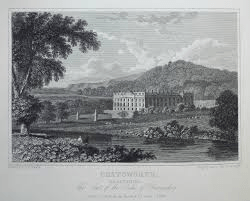
In Pride and Prejudice the heroine, Elizabeth Bennet, is taken on a tour of the Peak District by her aunt and uncle. There is mention of Matlock, Chatsworth, Dovedale and the Peak as being the main attractions. They base themselves in ‘Lambton’, often taken to be Bakewell, from where Pemberley is a three-mile drive. When they visit the house its setting makes a positive impression on Elizabeth: ‘…it was a large handsome stone building, standing well on rising ground, and backed by a ridge of high, woody hills – and in front a stream of some natural importance is swelled into greater …’ . This description has encouraged the identification with Chatsworth, but there are three objections to the theory. First, as mentioned above, there’s no record of her visiting the area, second the description of the house is generic, and could apply to many mansions from this period. Landscape fashion from the eighteenth century had created dozens of similar park-like vistas and Austen would have seen engravings such as the one above. Finally Pride and Prejudice, although only published in 1813, was largely written in 1797, 11 years before her supposed visit to the county.

A post-chaise

The search for originals of fictional people and places is quite pointless, since it assumes that authors have no powers of invention. More interesting is the light that the story sheds on early tourists in the Peak. Even if she had never visited Derbyshire, Austen was well aware of the tourist sights, which wealthy travellers could best enjoy by hiring a chaise, a small light carriage for two or three people. Complete with driver, this would cost about a guinea a day, roughly £100 in modern money.

Mather’s Grave

Mathersgrave near Brackenfield

Just north of the Matlock-Alfreton road (A615), the hamlet of Mathersgrave commemorates both a family tragedy and a medieval mindset. Set in the retaining wall to a cottage garden is a block of stone inscribed ‘SM 1643’ and nearby is a guidestoop with three inscriptions: ‘Matlack (sic) Road’, ‘Bakewell Roade’ and ‘Alfreton Road 1730’. The presence of the guidestoop shows that this was a significant crossroads in the early eighteenth century; building the turnpike bypassed the junction.

Guidestoop and grave stone

Christian teaching in the Middle Ages insisted that suicide was a serious sin, and this was reinforced by English law which viewed it as a crime, punishable by the forfeit of property to the crown. Suicides were denied burial in consecrated churchyards, and thereby lost their chance of going to heaven. Instead they were buried at crossroads, where it was thought their spirits would be unable to choose the right route back to the land of the living, and so be unable to plague their kin. To make doubly sure, a stake might be driven through the heart of the sinner to further immobilise them. Incredibly, the last case of a crossroads burial was in 1823, while suicide remained a crime until 1961.

Trinity Chapel near Brackenfield

Apparently SM was Samuel Mather, a local man who had fathered an illegitimate daughter, and social condemnation forced him to kill himself, and possibly kill his wife also. (Details of the story are vague). This happened in 1716, so the date on the marker stone is wrong. This occurred well before the Matlock-Alfreton turnpike was constructed, and further evidence of the shift in road pattern is the romantic nearby ruin of Trinity Chapel. Half a mile to the north, (see map above), this was in use before Brackenfield Church was opened in 1857, but is now quite deserted. In the past this must have stood on a busy lane, but today is only reached by footpath.

Old roads meet iron roads

Early North Midland train at Ambergate viaduct with waggon on road below

With the opening of the North Midland Railway line from Derby towards Chesterfield in 1840 the pattern of transport in the area was transformed. Faster and cheaper movement of both freight and passengers would lead to the eclipse of the turnpike roads. But in the very early period rail travel was regarded as exotic and probably dangerous. A gentleman’s private coach could be loaded onto a flatbed truck, saving his family the need to mix with the hoipolloi. Yet railway companies were keen to make travel a comfortable experience for their better class of customer, in a way that’s hard to imagine today.

South Wingfield Station after restoration

This is demonstrated by the facilities at South Wingfield Station, recently restored to its original form by Derbyshire Historic Buildings Trust, working with local volunteers, and with a substantial grant from the Lottery Heritage Fund. This was one of the earliest stations in the country, designed by architect Francis Thompson. The building had a booking office and two waiting rooms, complete with handsome fireplaces, all maintained by several staff, including a stationmaster who lived in a nearby house. Today’s travellers, huddled in a draughty platform shelter, can only dream of such luxury!

As it was

South Wingfield Station, which became redundant in the 1960s, is some distance from its village, yet it was originally advertised as convenient for Alfreton too! This was because Robert Stephenson engineered the line to run up the gentle slope of the Derwent and Amber valleys, since early locomotives weren’t powerful enough to deal with steep climbs. The Nottingham to Newhaven turnpike ran near the station, heading for Crich, and would have another twenty or so years of life before the spreading railway network put it out of business.

South Wingfield Station can be seen from the public footpath which runs through the station yard. See the website below for more background information and details of guided tours:

https://www.derbyshirehistoricbuildingstrust.org.uk/wingfield-station-our-project

On the slow road to Wirksworth

The Road to Wirksworth/ George Turner

This painting is one of several with the same or similar titles and visual ingredients. The artist, George Turner, seems to have specialized in rustic views of his corner of Derbyshire, such as the example above, which must have been painted looking north at a junction on today’s B5023, Duffield to Wirksworth road. Dating from the start of the twentieth century, there is clearly little traffic, given the small flock of sheep dozing on the carriageway. The unsurfaced track looks quite stony, while the shepherd and his collie seem rather under-employed. Turner must have found this a successful formula for his work, since many other landscapes have similar content.

The other Turner

George Turner (1841-1910) was born in Cromford, and became a self-taught artist and art teacher. With his first wife Eliza he also farmed near Barrow-on-Trent, as depicted in some of his work. When she died in 1900 he moved back to the region of his childhood, first to Kirk Ireton and then to Idridgehay, which is on the Wirksworth Road. He then remarried Kate Smith, 30 years younger than him, who was also an artist. They lived there for the rest of his life, and he is buried in the churchyard. His son William, by his first wife, continued painting in the same vein. Turner’s work is in several local municipal galleries and currently can sell for several thousand pounds.

Lane at Gorseybank, Wirksworth/ George Turner

This view seems to be just outside Wirksworth, at Gorseybank, possibly on Prathall Lane. Some perennial themes are included, such as the shepherd with his mini-flock dozing away, but this time he has company: presumably his wife, and their child playing on the verge. Once again traffic must be minimal, and judging by the foliage it is early autumn. In the background can be seen the higher ground that encloses the town. Clearly Turner found it profitable to present the Derbyshire countryside as a static, timeless setting; even the sheep are motionless. The sky is quite blue, the branches wave about a bit, but nothing much else happens. A far cry from the nearby mills, quarries, mines, forges and railways which by this date had moved into the Ecclesbourne Valley!

Snakes and dukes

The Snake Inn: Still a challenge for cyclists

The Snake Pass on the A57 Sheffield to Manchester route was one of the highest turnpike roads in the country, and is still plagued by winter closures due to snow and landslips. Reaching a height of 1,680 feet, it offers the most direct route between the two cities and may have been in use for thousands of years, yet there is little agreement about its history. On the 1:25,000 OS map much of the route as shown as a Roman road, and is named ‘Doctor’s Gate’, but although there was a 16th century Vicar of Glossop called Doctor Talbot there is little hard evidence to date the road further back in time.

A winding story

The Derbyshire Portway can be clearly traced from the Trent to Mam Tor, and from there the best route north is eastwards along Edale, then to climb up into the Woodlands Valley which heads northwest to the Pass. Today the bridleway lies to the west of the main road at first, then switches to the east above Alport Bridge, since the going is easier on that side. However, apart from the place name ‘Alport’ there is little evidence for speculation about its history, not even for the ‘Roman’ road – Dodd and Dodd (Peakland Roads and Trackways) claim that some Roman paving can be found, but such stonework is almost impossible to date and at this altitude it seems unlikely to have survived on the surface. However, Doctor’s Gate may well have been a medieval packhorse route.

A slippery snake

In the early nineteenth century the Dukes of Norfolk and Devonshire – principal landowners in the area – decided to build a turnpike road over the Pass to encourage trade between South Yorkshire and Lancashire. Part of the route, from Glossop up to the top of the Pass, was a completely new route, and this partly accounts for the debts that the Trust, established in 1818, ran up. There is some confusion about the engineer responsible: the Glossop Heritage website claims it was John Macadam, while other sources (e.g. Dodd and Dodd) say Telford. The road opened in 1821, but the arrival of a railway in 1845 was powerful competition, and when the Trust was wound up in 1870 it had debts of many millions, in modern terms. Since then the Pass has posed continual problems for the highway authority, being regularly closed by snow and landslips: all of which must add to the difficulty of keeping the Snake Inn, near the top of the Pass, running.

What about that snake? Nothing to do with the winding road – it’s the emblem of the Cavendish family, joint financiers of the road, seen here at Chatsworth.

Hemlocked

The Hemlock Stone

The Hemlock Stone on Stapleford Hill west of Nottingham is a sandstone pillar about five metres high, set in parkland. The name suggests that it may have acted as a boundary marker between Derbyshire and Nottinghamshire, and it is found near the Portway’s crossing of the Erewash (the county boundary). It seems to have had more significance in the past, with eighteenth-century references to its use for Beltane celebrations, and was famous enough for DH Lawrence to include it in Sons and Lovers as the destination for an Easter walk.

A barefoot Lawrence at the University of Nottingham

The walk from Eastwood to the Hemlock Stone had actually taken place in 1905, organised by Lawrence for his family and friends. Beginning in the town, the original route is now difficult to follow due to the construction of the A610 on the line of the old railway, but the walking party first crossed the semi-derelict Nottingham Canal, then the Erewash, and thirdly the Erewash Canal, soon coming to a footbridge over the Midland mainline railway, whose express trains linked Eastwood and Langley Mill to London. The party next joined the Heanor-Ilkeston road and followed this through Ilkeston, a town Lawrence knew from his teacher training. Their route then turned towards Stapleford: today mostly built up but following pleasant country lanes a hundred years ago. It is interesting that the Stone was seen as a significant destination, worth a fourteen-mile walk (at least), and was clearly a popular spot:

‘Everywhere in the field below, factory girls and lads were eating lunch or sporting about’.

Jessie Chambers, the model for Miriam Leivers

In the novel the importance of this walk is the emerging love between the hero, Paul Morel, and Miriam, the girl from Haggs Farm (a thinly-disguised Lawrence and Jessie Chambers). Both felt rather alienated from the rest of the party, who were inclined to climb the Stone and carve their names there. On the way home they both fell behind the others, Lawrence struggling to repair an umbrella, and their mutual sympathy developed into a complicated affair which dominates the first half of Sons and Lovers and has become a classic of teenage angst.

A lovely day out in the Bath

Today Matlock Bath rarely seems short of visitors; even in winter there will be customers for ice cream, and car parks fill up by mid-day. But in the past, especially before the railway arrived in 1849, and when road access was challenging, the village had to work harder to attract travellers. Early fame depended on the waters, of course, but wallowing in a lukewarm bath had limited appeal, yet the spectacular landscape of High Tor to one side and Masson Hill opposite was the subject of many paintings, helping spread its reputation. Local entrepreneurs began adding to the natural beauty, starting with Lovers’ Walks, on the east side of the Derwent, and originally only accessed by ferry or from Willersley. The Walks are first mentioned in 1742, making them possibly the earliest public ‘park’ in the country. Paths were created by the river and up the hillside, with seats, shelters and ornaments provided to enhance the views.

View of Matlock Bath from the Heights of Abraham c. 1840s

Presumably eighteenth-century visitors were more energetic than modern holidaymakers, since before the cable cars were installed reaching the Heights involved a steep-ish walk. Opened in 1787, the rather quirky name derives from the supposed similarity to the Heights of Abraham in Quebec, where General Wolfe died in 1759. These gardens offered views over the valley, improved by building the viewing platform of the Victoria Tower in 1844. Clearly, hillside walks were a limited attraction, so the old lead workings in Masson were opened up to visitors, now named Masson Cavern and Rutland Cavern, both continuing to offer some spectacular sights.

The Switchback Railway, Derwent Gardens c. 1910

About 1887 a craze for ‘switchback’ railways, a basic kind of gravity operated roller coaster, swept the country. The Buxton family bought and ran Matlock’s version, which had been built on the site of Derwent Gardens, and it continued operating until about 1930. Judging from the photos it would have never passed Health and Safety inspections, but was apparently extremely popular!

Matlock Bath Illuminations, or Venetian Nights, dates back to 1897, when it was an attempt to prolong the holiday season into the autumn by offering a spectacular display of illuminated boats, accompanied by fireworks. These have continued up to the present, with breaks for wars, floods and, of course, Covid-19. Especially in the 1920s and 30s there was strong competition for the prize for the best boat, and some of the remarkable winners can be seen on the Andrews pages at:

https://www.andrewsgen.com/matlock/pix/matlockbath_illuminations_boats.htm

Completing fishermen

The elegant Mr Cotton

Charles Cotton (1630-1687) was the owner of (the now demolished) Beresford Hall in Beresford Dale, on the upper reaches of the River Dove. As a Royalist sympathiser he found it prudent to live quietly in the country after the Parliamentary victory, but he was also a notable writer who wrote poetry in praise of the Peak District, as well as a best-selling handbook on games. But today he is mainly remembered as a fishing enthusiast who built a fishing ‘temple’ in his grounds on the Staffordshire side of the river. This still stands, on private land but visible from the footpath on the Derbyshire side. Over the doorway the initials CC and IW are intertwined, commemorating his friendship with Izaak Walton.

The fishing temple

Walton (1593-1683) was born into an innkeeper’s family in Stafford but seems to have been socially mobile, moving to open a linen draper’s business in London and becoming friendly with the local vicar, John Donne. But he was also a committed Royalist, and retired to Staffordshire after the War, where he bought land. His political leanings may have cemented his friendship with Cotton, but angling was probably the main tie, and Walton’s most famous work was The Compleat Angler (1653), to which Cotton later added some chapters. This book has gone through scores of editions in the past 370 years, yet is frankly almost unreadable today. Walton, who was 37 years older than Cotton, must have been good company, for he spent the last half of his long life staying with friends, and in some cases writing their biographies, including George Herbert and Richard Hooker.

Izaak on the job

In Cotton’s part of The Compleat Angler he describes a journey from Asbourne north to Milldale, in the form of a dialogue between a traveller (Viator) and a fisherman (Piscator), which emphasises the horrors of Derbyshire roads – this is the descent into the Dale:

Viator: It is as steep as a penthouse.

Piscator: To look down from hence it appears so, but the path winds and turns, and will not be found so troublesome.

Viator: Theses stones are so slippery I cannot stand. What’s here, a bridge? Do you travel in wheelbarrows in this country? This bridge was made for nothing else – ’tis not two fingers broad.

Piscator: I have rid over the bridge many a dark night.

Today the bridge at Milldale is still called Viator’s Bridge.

Unwillingly to school …

The young Alison

Today few young children walk to primary school alone, for a variety of reasons including parental perceptions of danger. In fact, the image of mum in a large Range Rover driving her offspring to the school gates has become a cliche. Yet 150 years ago children who were lucky enough to go to school often had to walk for miles, especially in rural areas. To some extent this walking may have formed part of their education, as was the case with Alison Uttley, who later became famous for her Little Grey Rabbit books. Alison grew up in a struggling farming family at Castletop Farm between Cromford and Lea Bridge. She didn’t go to school until she was seven, due to the remoteness of their farm on Hearthstone Lane.

Lea Primary today

Lea Primary School on Church Street, Holloway was chosen by her parents due to its good reputation. But the journey home, although only a mile and a half long, meant walking from school down to Lea Road, past John Smedley’s mill at Lea Bridge and then climbing up through Bow Wood on what is now a rough track (but which was the old road before the turnpike was built by the Derwent), and emerging from the wood just below the farm. Alison had to do this walk twice a day, in all weathers, and in winter the homeward stretch would be in the dark, for which she was given a lantern.

The path through Bow Wood

Clearly the fears she felt on her walk had a major impact, for she describes the journey in several books:

“I set off home, running for the first mile, for it was downhill and easy. Then I passed a mill and walked up a steep field where cows grazed. I came to the wood, and stopped at the big gate to light the candle in my lantern. I shut the gate softly so that ‘they’ would not hear. The treees were alive and awake, they were waiting for me…”

She obviously had a powerful imagination, and perhaps this walk could be credited with launching her career as a storyteller, since she sometimes persuaded a school friend to walk with her, with the incentive of listening to the stories that Alison made up as they walked.

Alison’s walk to school can easily be followed today, either starting from Cromford Station and walking uphill to Castletop, and then through Bow Wood to Holloway, or the reverse route starting from Lea Primary School.

Sources

Judd, D (2010) Alison Uttley, Spinner of Tales, Manchester University Press

Uttley, A (1951) Ambush of Young Days, Faber & Faber

Goodbye to another pub?

The Jug and Glass at Lea Green, pictured above, is the latest in a long list of Derbyshire pubs that have closed in recent years. Just in the Matlock area these include the Lime Tree and the Crown in Matlock itself, the Jovial Dutchman and the King’s Head in Crich, the Yew Tree in Holloway, the Nelson at Bullbridge, the Derwent Hotel at Whatstandwell, the Homesford Cottage on the A6, the George and the Vaults in Wirksworth, and many more. So what accounts for this spectacular collapse of what is still seen as an important English institution?

For sale in Chesterfield – The historic Royal Oak

Although pubs are now seen mainly as a community resource and valued for providing a meeting space for local clubs, inns (as opposed to alehouses) originally catered to travellers, and provided meals, beds and a change of horses, as well as drink and company. Inns must certainly date back to Chaucer’s time (c. 1370), since his pilgrims stay at the Tabard in Southwark, and are probably much older. But the arrival of railways reduced their importance, and drink drive legislation was a further blow. Today’s traveller is lucky to find any wayside pub or inn open, since so many have had to restrict their opening hours.

The classic look

There are many reasons for the recent decline in pub-going. The price of beer, pushing £5 a pint in places, and the shortage of staff willing to work unsocial hours, made worse by the folly of Brexit, all contribute. But perhaps the critical factor has been the reluctance of many to enter a communal space, which was exacerbated by the pandemic. ‘Pub’ stands for public house, which means a place where you can meet your neighbours on neutral ground. Yet it seems that more and more people prefer to drink in the safety of home, where the drinks are cheap, and there’s no danger of having to talk to a stranger.