551 signs … and counting!

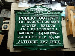
An early sign being restored

Have you ever found your footpath ploughed up, or a stile that would challenge a mountain goat? Help is available, thanks to one of Britain’s oldest societies for the protection of walkers’ rights. The Peak and Northern Footpaths Society was formed in 1894, but has its roots in an even older Manchester footpaths society dating back to 1826. Today, post-pandemic, the Society is stronger than ever, with about 1,300 members spread over Lancashire, Yorkshire, Derbyshire, Cheshire and nearby areas. Although it does organise regular walks on both sides of the Pennines it is far more than a walking club, liaising with local authorities on a range of issues, and most noticeably erecting signs throughout its region.

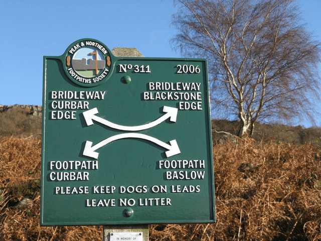
A more modern version

There’s something very reassuring for a walker who finds one of their signs at an uncertain crossroads, and currently there are 551, maintained by a dedicated team who also repaint them when necessary. In addition the Society has 172 footpath inspectors who are responsible for monitoring the paths in one or more parish. All these, as well as the staff at the Stocktport base, are volunteers, so that thousands of miles of paths, spread over five or more counties, are effectively kept open by the combined efforts of hundreds of unpaid people who share an enthusiasm for the right to walk freely.

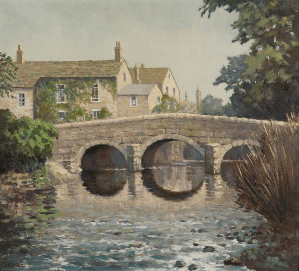
Bridge at Kirklees partially funded by the PNFS

Quite recently the Society has also started helping to pay for footbridges at critical points on the footpath network. This is a recognition that local authorities, who are actually largely responsible for footpath maintenance, either can’t or won’t do their job. Although there are responsive councils, due to years of ‘efficiency savings’ rights-of-way staff have been repeatedly cut back, so that in this region we are lucky to have such a dedicated voluntary body doing part of the job for them!

There are many benefits to joining the Society, which only costs £15 a year for an individual, but perhaps the main one is the knowledge that you are contributing to the maintenance of one of our greatest unsung assets, our footpath network. See:

http://www.peakandnorthern.org.uk/membership/index.htm

Harboro’ highlife?

Harboro’ Rocks seen from the High Peak Trail

A couple of miles west of Wirksworth, just above the High Peak Trail, Harboro’ Rocks are a distinctive limestone outcrop rising to 379 metres. The summit offers a splendid view of Carsington Water to the south and the Via Gellia valley to the north, while providing practice pitches for climbers. The Rocks have been the subject of several archaeological digs, the latest reported in the Derbyshire Archaeological Journal (Makepeace 1990 and 2004). According to these, evidence was found of a Late Bronze Age or Early Iron Age settlement: pottery fragments, domestic animal bones, a flint tool and a button. There is also a remarkable cave in which Daniel Defoe found a lead-ming family living in 1720, and which clearly could have been occupied in prehistoric times.

Cave at Harboro’

However, this picture ignores three factors. First, why should anyone settle on such a bleak and elevated spot, with no source of water? The thesis also fails to mention that the Rocks are near the junction of two important ancient routes: The Street, which was engineered by the Romans over an older ridgeway and ran from Wirksworth to Buxton, and the Portway, which headed north from Harboro’ towards Mam Tor and beyond. Finally, the name ‘Harboro” goes back to at least c. 1200 CE and may mean ‘shelter’ or ‘fortified place’, according to Cameron (1959). What must be significant is that this name crops up on two other hilltops along the Portway’s route: Arbour Hill outside Dale and another Arbour Hill in Wollaton.

Burdett’s map of 1762 showing roads west of Wirksworth and position of the Rocks (arrowed)

So my suggestion is that this was not the site of a Bronze Age ‘settlement’, but could have been a fortified campsite for travellers on these two important routes. This would account for the sparse nature of the finds from the excavations – people were travelling light. Similar to the caravanserai found in the Middle East, these campsites seem to have been spaced every six or seven miles along the Portway and would have given the travellers some security for themselves and their animals when they stopped for the night. The next, going southeast, is Alport Height, and to the north, Cratcliffe Rocks.

Inns for travellers were part of the Roman road system, but I doubt whether any were provided in such a backward area as Derbyshire. We can only guess how these campsites were organised; whether locals sold water and provisions to travellers, and how they were maintained. However, there is enough evidence to suggest that these places provided vital protection for long-distance wayfarers until the growth of towns and the development of the modern inn during the medieval period.

Baslow and beyond

East end of Baslow old bridge

Driving on the busy A623 through Baslow today, it is easy to miss the medieval bridge next to St Anne’s church. Yet this was part of an important route in the eighteenth century: carrying the turnpike from Monsal Head to Chesterfield, while before then it carried packhorse traffic heading for East Moor and Sheffield. In 1500 an order was issued forbidding the carriage of millstones over the bridge; presumably their weight was damaging the earliest structure (which may have been wooden at that date). The small stone hut at the end of the bridge is sometimes called a watchman’s shelter, but elsewhere it is presumed to be for a toll collector. However the entrance is so low it is hard to imagine how this would work, unless the job was given to a child!

Lady Well, Bar Road

The old route can be followed from the bridge by crossing the main road and following School Lane uphill. This takes you through the heart of the old village but then continues more steeply uphill as Bar Road. Although this name may suggest a barrier or turnpike, according to Dodd and Dodd (1974) Bar was a name widely given to tracks that led down from the moors. Rather confusingly, Burdett’s map of 1762 tautologically names the river that flows through Baslow into the Derwent ‘River Barbrook’. Higher up Bar Road, beyond the houses, is the Lady Well, providing a welcome drink for travellers and their animals before climbing the last stretch up onto the moor. Once on the top, various landmarks such as the Eagle Stone and the Wellington Monument provide guidance.

Painting of the old bridge

Gell the Roman?

When I was a child we were occasionally driven into Derbyshire as a holiday treat, and coming down the Via Gellia was one highlight of such trips. It seemed a very romantic route, winding and well-wooded within the steep-sided valley, with mysterious caves inviting exploration. Today the road seems a little less fascinating, more overgrown with trees, and with massive quarry trucks weaving round every bend, yet it is of historical interest in that we know (unusually) when and why it was built, and by whom.

Philip Gell the hunter

The Via Gellia is not the only road in Derbyshire to be named after a person; for instance there is the Sir William Hill near Eyam, but it must be a unique case of a Latinized family name! The Gell family had lived at Hopton Hall for generations, near where they had profitable quarries and lead mines. Philip Eyre Gell (1723-95) inherited the estate at the age of 16, but postponed marriage till he was 50, in 1773, when he married the 16-year-old Dorothy Milnes. Their first son, another Philip, was born in 1775.

Burdett’s map of 1791 shows a track from Cromford to the mill where the Bonsall Brook drops down the Clatterway, but nothing beyond that point. The building of the Via Gellia is generally dated to 1791/2, and was designed to allow carts of lead ore or stone to travel down from the Hopton area to the canal and lead smelters at Cromford. Nobody knows who gave it its name, but one possibility is Philip Gell’s second son Wiliam, an archaeologist who had visited the ruins of Pompeii. Perhaps his interest in Roman civilization and knowledge of Roman road names such as the Via Appia led him to christen his father’s road in Roman style, hinting at an improbable family history dating back over a thousand years?

Tufa Cottage, situated about half-way down the route, must have been built by the mid-nineteenth century, originally for a gamekeeper on the Gell estate. Tufa is a kind of porous limestone found locally, with a distinctive coarse texture. Today it is notable for the cable car in the front garden!

Mr Wright paints Cromford

Wright: Arkwright’s Mill in the late eighteenth century

Paintings and prints can help us understand the development of the road system, and reveal historical features not shown on maps. As Matlock Bath became an established tourist attraction in the late 1700s, visitors were also keen to visit Arkwright’s mill just up the road at Cromford, and be impressed by the scale of the buildings. One of these ‘industrial tourists’ was Joseph Wright of Derby, who painted the mill both by day and at night, when the rows of candlelit windows must have been a remarkable sight in this very rural location. The painting above appears to have been made from a location close to the modern High Tor cafe by the Cromford crossroads, looking down the road towards Cromford Bridge. But this area has been radically changed by cutting through the Scarthin Rock, a process begun in 1817 but not finally completed in modern form until 1962. The painting clearly shows the mill leat on the far side of the road, which led to the aqueduct above the road (damaged quite recently and sadly never replaced). The Bonsall Brook is shown on the nearside of the road (not visible today), and the main building is taller than today’s mill. In the distance the tower of Crich Stand can be clearly seen, which at the time of the painting had been recently (1785) rebuilt in stone by Francis Hurt, a major local landowner.

Wright: Willersley Castle and Cromford Church

Another view of the area has the Matlock Bath road in the foreground, and is framed again by Scarthin Rock. It is difficult to find this viewpoint today due to the increase in tree cover: in Wright’s time the valley was quite bare. Both Cromford church and Willersley Castle must have been very recent when this was painted; in fact the church was not finished until 1797, the year of Wright’s death. The painting illustrates the first appearance of the church; the current porch was added in the mid-nineteenth century. Next to the bridge the small fishing house is clearly visible.

Wright: Cromford Mill by night

The third painting is an example of Wright’s interest in dramatically-lit night scenes. Although the view is from a similar spot to the first picture, the road now runs to the left of the mill, not the right. It must be assumed that this is artistic licence, since the road in the first picture is so clearly on the line of the present one. Clearly, the details of such pictures cannot be assumed to be reliable, but it’s worth noting that the two-storey building in the foreground, which is not shown in the first view, survives today in the same form.

On the road with Joseph Andrews

Henry Fielding (1707-1754)

Many of the earliest novels were effectively ‘stories of the road’, their plots centred on the journeys their heroes were making – books such as Don Quixote and The Pilgrim’s Progress – while the form is still popular today e.g. The Lord of the Rings. This format provided the possibility of introducing a rich cast of characters and a variety of adventures, but also gives the modern reader an insight into travel at that period: naturally a dramatized picture but one that had some basis in reality. One of the best early ‘road novels’ is Joseph Andrews by Henry Fielding, published in 1742. Joseph, the hero, is a poor unworldly servant who flees the unwanted advances of his aristocratic mistress, Lady Booby, in London and sets off to visit his sweetheart, Fanny, in rural parts. He has only walked a few miles before he is robbed and stripped naked by a couple of heartless footpads, who throw his apparent corpse into a ditch.

Joseph resists temptation

Luckily for Joseph a stagecoach pulls up, but every single passenger rejects the idea of rescuing the injured man – the ladies on account of his nakedness – until a lawyer points out that if they don’t take him to an inn they are possible accomplices to his murder. Only the postillion is prepared to lend Joseph his greatcoat, which allows him to board the coach. The coachman takes the injured man to the nearest inn, the Dragon, where he gets a sympathetic welcome from Betty, the chambermaid, who prepares a bed, and Mr Tow-Wouse, the landlord. However, neither Mrs Tow-Wouse, nor the local surgeon, nor the parson are prepared to help Joseph; the landlady complaining bitterly of her husband’s kindness and moaning that Joseph should have gone to an ale-house (inns, of course, preferred customers from the gentry).

Ale-house or inn?

All this in the first few chapters, and there follow enjoyable satires on inn-keepers, surgeons and vicars, culminating in Mrs Tow-Wouse discovering her husband taking advantage of Betty’s good nature, and Betty’s rapid departure. Happily, Joseph meets an old friend and together they set off for more adventures en route to Fanny. None of this needs be taken to be a realistic portrayal of eighteenth-century travel, yet it does reflect popular fears and concerns about the perils of wayfaring.

Clegg’s travels

The chapel at Chinley today

James Clegg (1679 -1755) was for many years a minister at Chinley Chapel, near Chapel-en-le-Frith in north Derbyshire. There are no surviving pictures of him, but we know more about his life than is usual thanks to his diary, which he kept from 1708 until his death. As it was frequently necessary at that time to have several ways of earning a living he also had a farm and trained as a doctor, a vocation which would have fitted in well with his spiritual duties. The record he kept of his journeys in the diary gives us a valuable picture of personal movement in the pre-turnpike era. He was originally from Lancashire, and family concerns caused visits to the Manchester area, as well as to Chesterfield to see his sister, but he also occasionally went to Lincolnshire, Nottingham and Derby, besides Macclesfield and Leek. In addition there were many shorter journeys for medical and religious reasons in the Chapel district.

Clegg’s tomb at Chinley Chapel

The longest journeys he made on horseback were just under thirty miles, and as the average speed of a rider at this time is thought to have been about four miles an hour (given the state of the roads) this journey would have meant seven hours in the saddle. An analysis of his travels in the first six months of 1730 shows that he rode about a thousand miles overall, with a noticeable increase as the days got longer, from 69 miles in January to 286 miles in May. Clegg rode his mare in all weathers, although he rarely mentions this except when extremely snowy. Occasional phrases in the diary remind us of the hazards of travel in the period:

… the night being very dark I narrowly escaped a dangerous fall into a stone pit which my mare jumped into’.

However, despite such episodes Clegg’s 76 years are a testament to his remarkable versatility and vigour.

Afoot with Karl Moritz

Karl the wanderer

Karl Moritz was a prolific German writer who, in 1782, spent two months touring England, reaching as far north as Derbyshire. Clearly an adventurous character, what is especially striking is that he traveled on foot, when all but the poorest went on horseback. This gives his writings an unusual perspective, and his experiences, at a time when foreigners were rare in these parts, provide an interesting insight into the realities of travel in the late eighteenth century. Leaving Derby (‘a small, but not very considerable town’) he finds the village children very civil, bowing to him as he walked. In Duffield (‘a long and extensive village’) he is pleasantly surprised when, at the inn, he is shown into the parlour for a meal. This is in contrast to previous inns, where foot travellers were relegated to the kitchen.

The Bear, Alderwasley, today

It is interesting to try to reconstruct his journey from Duffield to Matlock. The turnpike was a ridgeway through Belper Lane End and on to Bolehill and Cromford, and he speaks of staying the night at an inn ‘about five miles from Matlock’. This could have been the Bear at Alderwasley, which is shown on a map of 1761 as ‘Brown Bare’. Here he finds the kitchen full of boozy farmers, and as he accidentally fails to drink the landlord’s health he is sneered at for his ignorance. Naturally he was pleased to leave ‘this unfriendly roof’ the next morning and head for Matlock Bath, which produced the standard romantic reaction:

The situation of Matlock itself surpassed every idea I had formed of it. On the right were some elegant houses for the bathing company … to the left, deep in the bottom, there was a fine bold river, which was almost hid from the eye by a majestic arch formed by high trees, which hung over it.

Nineteenth-century painting of High Tor, Matlock

After seeing this ‘Paradise’ Matlock town was disappointing (‘scarcely deserves the name of a village, as it consists of but a few and miserable houses’). From there he walked to Bakewell, enjoying the scenery:

The whole country, in this part, is hilly and romantic. Often, my way led me, by small passes, over astonishing eminences, where, in the deep below me, I saw a few huts or cottages lying.

After passing through Ashford, en route to Wardlow, he fell into company with two other walkers, one being a talkative saddler. Karl was surprised to find that he could quote from classical authors such as Homer, reciting passages from memory. The saddler also warned him to avoid Wardlow and head for Tideswell instead, which would offer better lodging.

Moritz’s visit must have been partly inspired by Matlock’s early reputation for romantic scenery, and of course he would be followed by many more tourists in the next two centuries, eager to experience the wonders of the Peak.

Too many ways?

Section of the Portway below Robin Hood’s Stride, aka the Limestone Way

It took 30 years for the first national long-distance trail, the Pennine Way, to be opened. In 1935 an article by Tom Stephenson suggested the creation of the route, inspired by American models such as the Appalachian Trail, but it was not opened until 1965, after years of haggling with landowners such as the water companies. Today its 260-odd miles from Edale to just over the Scottish border are still a formidable challenge, but it has been joined by the development of many more such paths.

The Ecclesbourne Valley Express

The various long-distance paths in Derbyshire have been developed for different reasons. For instance, the relatively new Ecclesbourne Valley Way (11 miles) provides users of the Ecclesbourne Valley Railway with the chance to walk all or part of the route from Duffield to Wirksworth. The Limestone Way (46 miles from Castleton to Rocester) was set up by the local council to promote tourism in the area. The 55-mile Derwent Valley Heritage Way, from Ladybower to the Trent, was created for similar reasons, and to tie in with the World Heritage Site status of the valley. A glance at the Ordnance Survey map will reveal more (green diamonds on the 1:25,000 map), such as the Midshires Way, Peak Pilgrimage or the Cuckoo Way.

On the Portway at Alport Height

Most of the recently created routes link up existing rights of way and waymark the entire track. As such they provide walkers with an alternative to circular walks, although clearly sections can be followed separately. However, only the Derbyshire Portway (55 miles from Sneinton, Nottingham to the Snake Pass) can claim to follow the approximate route of an ancient trackway. The problem with some of these recent routes is a lack of maintenance. It is surprising how quickly signposts disappear, waymarks are hidden by foliage, and even field boundaries are removed. Attempting to walk the Midshires Way recently we found that in the centre of one large field near Palerow Lane the route makes a 90 degree turn, which we missed as there was no marking at all, yet I imagine that few walkers want to be glued to a walking app. Providing proper waymarking, stiles and undergrowth clearance on these routes would be a trivial expense, and would certainly encourage more people to take to the hills.

Riding with Cobbett – 2

Statue of Cobbett at Farnham

In the early modern period, gentlemen – and the more daring ladies – preferred to travel on horseback. William Cobbett, touring England in 1822 for his masterpiece ‘Rural Rides’, explains this preference:

My object was … to see the country… and to do this you must either go on foot or on horseback. With a gig you cannot get about amongst bye-lanes and across fields, through bridle-ways and hunting-gates …

From his saddle Cobbett meets a rich variety of fellow travellers, who he reacts to with typical vigour:

On the road-side we saw two lazy-looking fellow, in long greatcoats and bundles in their hands, going into a cottage. ‘What do you deal in?’ said I to one of them, who had not yet entered the house. ‘In the medical way,’ said he. And, I find that vagabonds of this description are seen all over the country …

Near Uxbridge he mentions his amusement at seeing ‘in all various modes of conveyance, the cockneys going to Ealing Fair’, which sounds like a print by Hogarth come to life. Cobbett strongly sympathises with the situation of the rural labourers, as when he crosses the River Wey:

Here we found a parcel of labourers at parish work. Amongst them was an old play-mate of mine. The account they gave of their situation was very dismal. The harvest was over early … now they are employed by the parish … to break stones into very small pieces to make nice smooth roads lest the jolting, in going along them, should create bile in the stomach of the overfed tax-eaters.

Late nineteenth-century gypsy encampment

Cobbett is more positive when he meets a group of gypsies, whom he finds physically impressive:

At Cheriton I found a grand camp of gipsys, just upon to move to Alresford. I had met some of the scouts first, and afterwards the advanced guard, and here the main body was getting in motion. One of the scouts that I met was a young woman, who, I am sure, was six feet high …. The tall girl that I met at Titchbourn, who had a huckster basket on her arm, had most beautiful features. I pulled up my horse, and said, ‘Can you tell me my fortune, my dear?’

Still open for business – the Holly Bush at Headley today

One of Cobbett’s best qualities is the ability to laugh at himself. On one day’s ride he got thoroughly lost, as he refused to use the turnpike road, and spent hours being misled on bridle-ways by a guide, all in the pouring rain. He writes:

At the Holly Bush at Headley there was a room full of fellows in white smock frocks, drinking and smoking and talking, and I, who was then dry and warm, moralised within myself on their folly in spending their time in such a way. But when I got down from Hindhead to the public house at Road Lane, with my skin soaking and my teeth chattering, I thought just such another group, whom I saw through the window sitting round a good fire with pipes in their mouths, the wisest assembly I had ever set my eyes on.