Derby at the crossroads

This early plan of the town of Derby, drawn about 1760, shows how small the town was 250 years ago. The central area is framed by the Derwent to the east and Markeaton Brook to the west, at that time still an open stream. The town is divided into five parishes: All Saints (now the cathedral), St Alkmund’s, St Peter’s, St Michael’s and St Werbergh’s. There is only one bridge (St Mary’s, still in use) giving access to the Nottingham road. The Silk Mill is shown, as are other signs of small-scale industry such as a ‘pot works’ and a ‘copper mill’. The urban core is surrounded by what look like orchards, but may be market gardens.

The second map, made at the same time, gives an equally vivid idea of the size of Derby then, when settlements like Chester Green or Darley were well outside the built-up area. The turnpike roads are clearly shown, with numbered miles. The London road runs through Osmaston, the Nottingham road goes past Spondon (or Spoondon), the Chesterfield road via Little Chester, and so on. By the second half of the eighteenth century regular coach services ran from the county town to all the major Midlands towns, and Derby was an important stage on the Manchester- London route, where passengers would spend the night.

The Old Bell Hotel, Sadler Gate

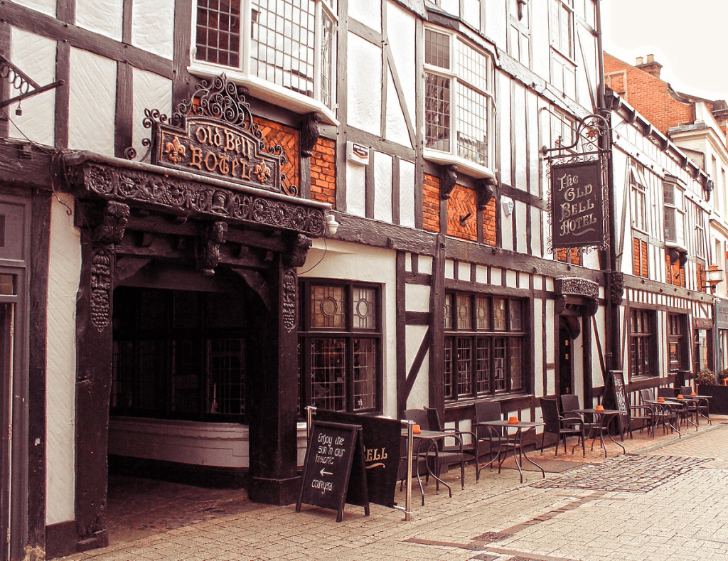
Road travel in the eighteenth century was transformed by both the use of steel springs on coaches after 1764, and the growth of the turnpike system. This is shown by the reduction in journey time on the Manchester to London route, from 62 hours (with two overnight stops) to 18 hours by the end of the century. ‘Flying Machines’ were advertised in the Derby Mercury in 1760 starting from Derby’s George Inn at a fare of £1-8 shillings. This is the equivalent of about £237 at modern values; a reminder that coach travel was not only uncomfortable but also very expensive. Among other Derby coaching inns were the Talbot and the Old Bell, the latter apparently the only survivor. Even on relatively smooth turnpikes, horses would soon tire, and would need changing regularly to maintain timing. By 1767 a coach left Derby three times a week at 9 pm and arrived in London by 7 pm the following day. Despite the (relative) speed, it’s easy to imagine the discomfort of this journey with only brief meal stops, and perhaps gain a new perspective on the comforts of travel on Midland Mainline!

Sources:

Burdett, P. (1791) Map of Derbyshire Derbyshire Archaeological Society

Twells, H. (1943) ‘Derby’s Flying Machines and earliest coaches’ DAJ 64: 64-82

All you ever wanted to know about paths

Jack Cornish is Head of Paths at the Ramblers, which must be an excellent qualification to write on the subject. His recent book, The Lost Paths, sets out to be ‘A History of How We Walk from Here to There’. Ambitious in scope, the 19 chapters include such familiar subjects as pilgrim routes and turnpikes, but also cover topics like the growth of railways and the effects of the new post-war towns on traditional paths. Some of his material, such as the enclosures of the eighteenth and nineteenth centuries, may be familiar to any reader with an interest in history, but other topics, for instance the loss of rights of way due to military requirements during the Second World War, are unusual.

The author has assembled a fascinating range of detail, such as the vogue for ‘pedestrianism’ in the nineteenth century, when large bets were put on improbable feats of walking, such as London to York and back in six days. But his concerns are not only historical, since he discusses the need to make access to the countryside more diverse and welcoming for minority groups. If anything, the reader may feel that he has tried to include too much: it is interesting to know how many bricks were used to build London’s first railway (six million) but not really relevant to the stated theme – there’s a certain loss of focus.

Yet his palette is impressively broad in terms of geography, and Derbyshire readers may enjoy his description of a walk from Cromford to Rowsley via Bonsall Moor, which he undertakes as a recreation of the ‘mystery hikes’ which were apparently popular between the wars – hikers would board a train for an unknown destination:

‘The drama of the landscape hits me quickly. Minutes after stepping off my train, my path takes me along the bottom of a massive cliff face. Trees grow up high, directly out of breaks in the rocks, their leaves rusting and falling to the ground’.

Cornish’s own involvement in the walking he writes about is clear, and he effectively balances these personal reports with the more historical details. He is also good at recounting disputes with landowners over rights of way, and sets the inevitable Kinder trespass story in the wider context of the long-standing struggles for access all over this country.

I would certainly recommend The Lost Paths to all fellow walkers, though with a couple of caveats. The title doesn’t really do justice to the scope of the book, which is much broader than it suggests, and the illustrations – small black and white engravings – add little beyond decoration.