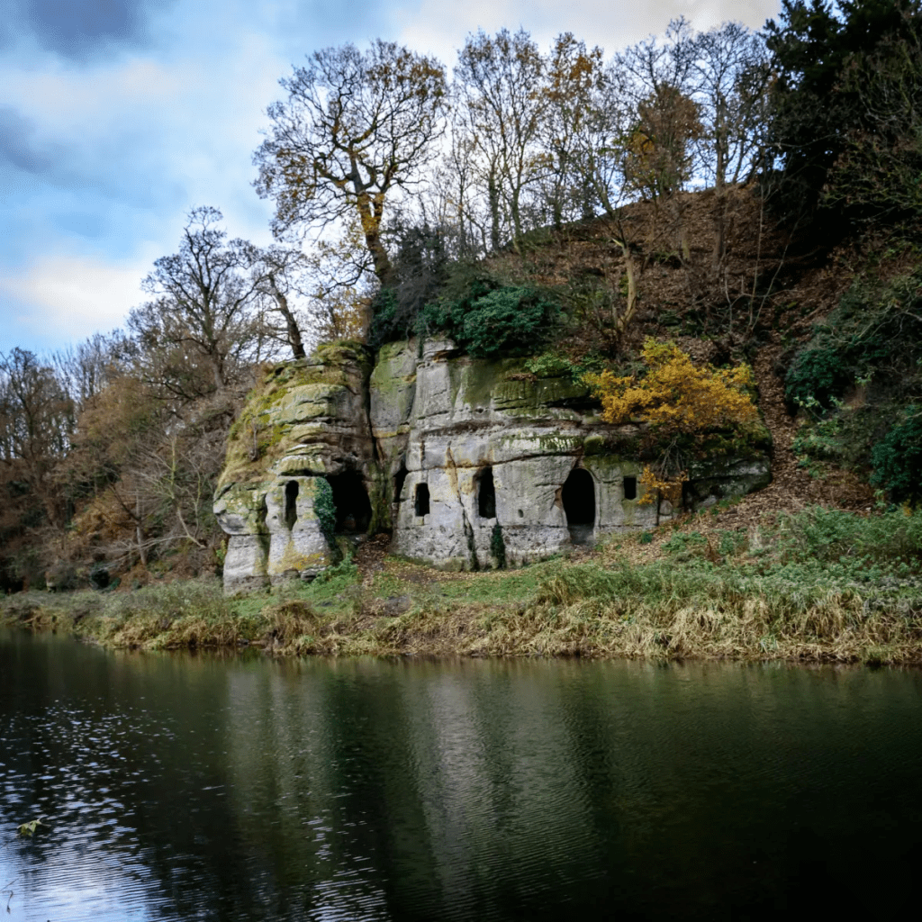
The ferryman at Anchor?

Anchor Church today

On the steep south bank of the River Trent, a short walk from Ingleby village, this rock-cut structure may have been used since the ninth century. Although the photo suggests that the river comes to the doorstep, in fact this is a pond, probably a remnant of an earlier course of the river, which has now shifted into a new channel to the north. Clearly cut out of sandstone, it is now thought that this was the refuge of the Saxon saint Hardulph, who had been deposed as King of Northumbria in 806 CE. He was buried at the nearby church of Breedon on the Hill, which is dedicated to him.

An interior view

The next stage in its history began in the thirteenth century, when it was the cell of an anchorite or hermit, hence the name Anchor. It is a mistake to imagine a hermit as a wild and solitary figure, leading a life of lonely meditation, and shunning contact with the world. Repton church and priory was quite near and may have been linked to the hermitage. It is also possible that the hermit was a part-time ferryman, at a time when the Trent ran at the foot of the rock. Burdett’s map of 1767 shows two ferry crossings nearby and upstream, one at Twyford and the other at Willington. Ferries were clearly quite common up to the nineteenth century, as a simple alternative to a costly bridge. Not only would this have given the hermit a useful function, but it could also have provided a small income.

An eighteenth century idyll

The hermitage presumably fell out of use with the dissolution of the monasteries in 1538, and the next records are from the eighteenth century when the landowners, the Burdett family of Foremark Hall, modified the structure for use as a summerhouse. This provided a suitably Gothic atmosphere for elegant alfresco parties, as can be seen in the print above. Sir Francis Burdett was a notable Radical who was actually briefly imprisoned in the Tower of London for libelling the House of Commons. Today the site is Grade II listed, and can be visited by footpath from Ingleby.

The hermit of the bridge

The causeway in the old days

Swarkeston Bridge was once the only crossing of the Trent between Burton and Nottingham, carrying traffic on the north-south route through the Midlands to Derby and beyond. At this point the river flows through low-lying meadows which flood regularly, and so the road is carried across these on a causeway about three quarters of a mile long. Most of this is medieval, although the actual river bridge was rebuilt in 1801. The whole structure is a clear illustration of the importance of river crossings in the past, and the resources that were devoted to constructing them. In this case, the legend tells of two unmarried sisters who lived on the north bank, and during a flood watched helplessly as their lovers tried to cross the torrent on horseback, before being swept away. As a result they spent all their resources on building the causeway, thereby impoverishing themselves.

Less peaceful today

Even when wealthy donors funded a bridge, maintenance was a constant issue. The Church seems to have been responsible for most bridges, and consecrated a body of men called ‘bridge hermits’, who were given an adjacent chapel to live in and were responsible for collecting tolls to pay for repairs. There are records, for example, of the Bishop of Ely in 1493 appointing a Robert Mitchell to the post and giving him a special outfit to wear. Although the bridge chapel at Swarkeston has disappeared there was also a chapel of St James by Chesterfield Bridge, while ruins of a chapel remain by Cromford Bridge. The best surviving example is by St Mary’s Bridge in Derby, which until the nineteenth century was the only crossing of the Derwent in the town.

Bridge and chapel in 1835

A list of the tolls charged (pontage was the term) for Swarkestone Bridge in 1275 is evidence of the extraordinary variety of goods traded in the region in medieval times. Tolls ranged from a farthing to 6 pence a load, although pedestrians were apparently not charged. This is a short extract from the list, but one wonders how the bridge hermit could assess all these tolls:

  • Any load of grass, hay, brush or brushwood – a farthing
  • Any horse, mare, ox or cow – a farthing
  • Any skin of horse, mare ox or cow- a farthing
  • Any pipe of wine – a penny
  • 5 flitches of bacon, salted or dried – a farthing
  • A centena of skins of lambs, goats, hares, squirrels, foxes or cats – a halfpenny
  • Every quarter of salt – a farthing
  • Every pack saddle load of cloth – three pence
  • Every sumpter load of sea fish – a farthing
  • Every load of brushwood or charcoal – a farthing
  • Every burden of ale – a farthing

Snowmotion

A recent winter view of Youlgreave

Winter has never been the best season for travel, but in the past it must have been far more difficult than today. Not only were roads much worse, but at times the weather seems to have been much colder. Especially in the upland areas of Derbyshire farms and villages were likely to be cut off by snowdrifts, with the constant threat of hunger if people were unable to reach markets. According to the Youlgreave Churchwardens’ records:

This year 1614 began the greatyst snow that ever fell within many memorye. And for heaps or drifts of snow they were very deep; so that passengers both horse and foot, passed over gates and hedges and walls it fell at ten severall times, and the last was the greatest … it continued by daily increasing until 12th day of March …

Snowdrifts at Farley above Matlock in 1947

The freezing winter of 1947, still within living memory, was made worse by the decrepit nature of the country’s infrastructure, worn out by years of war. Heavy snow began in late January and continued well into March. Conditions were primitive in many parts of Derbyshire, as recorded by a Mrs Alsop of Hulland Ward near Ashbourne:

All the local men were called by the council to leave their jobs to help clear the roads. This was all done by hand and shovels – no mechanical diggers in those days. The strong northeast, gale-force winds daily filled the roads. The men worked seven days a week for six weeks or more. … Younger folk trudged to Ashbourne (five miles or more) for bread.

In the Peak conditions were worse and neither roads or railways could be kept open, despite heroic efforts. Around Buxton, Longnor and the Staffordshire side of the Dove valley bombers were used to supply isolated settlements. Thousands of pounds of flour, sugar, jam and tinned goods were dropped by parachute. Tragically, one of the planes crashed on Grindon Moor, killing all eight on board. The weather finally relented in early March, when the landlord and landlady of the Barrel Inn at Bretton could leave the bedroom where they had been trapped for the past five weeks, having been dug out by rescuers.

Source: The Derbyshire and Nottinghamshire Weather Book (1994) Markam, L.