Church paths and coffin paths

Looking into Edale from Hollins Cross

In medieval England many parishes, especially in upland areas. were larger than they are now, and parish churches consequently were more dispersed. Although not everyone attended church regularly, for most people a churchyard burial was critical, since that was the key to an afterlife. As a result coffins often had to be carried several miles to the nearest consecrated churchyard. An extreme example is Edale, where the funeral processions from this scattered community had to cross the ridge into the Hope Valley via Hollins Cross, which marked the site where the coffin could be rested while the pall bearers had a much-needed rest on this four or five mile journey to Hope church.

Paths around Horsley church (centre)

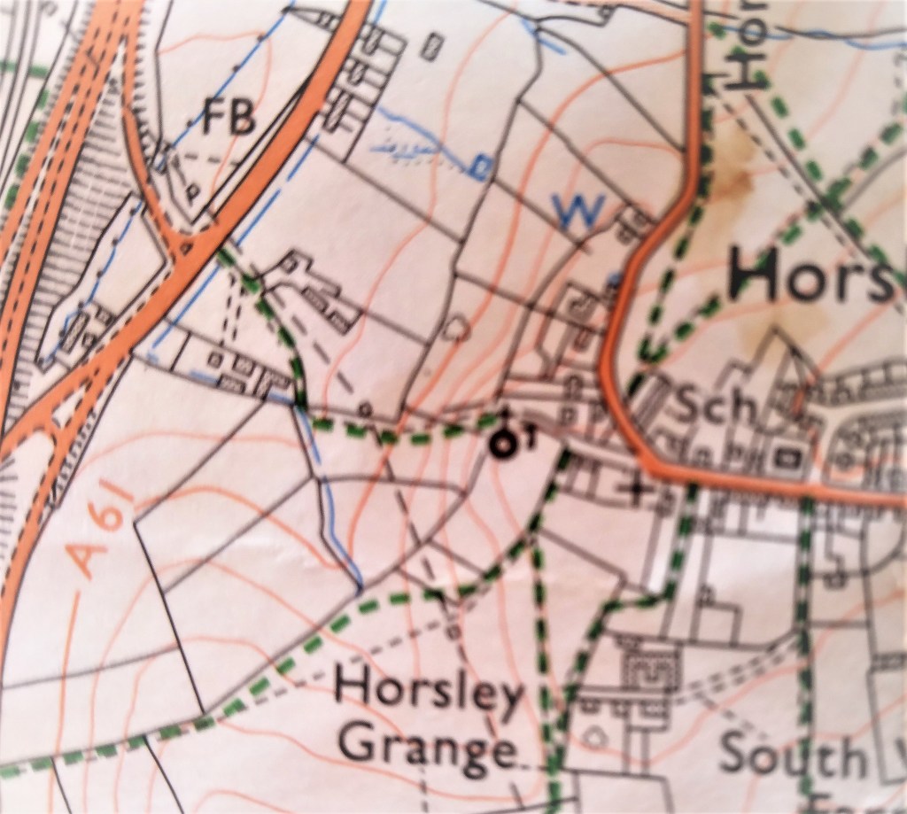
Many churches are at the centre of a network of paths, as can be seen in the case of Horsley, to which at least five footpaths lead. Other examples include Bonsall, Crich and Morley. Of course these routes were not only for funerals – they would also have provided a direct route for Sunday worshippers. Especially before the growth of non-conformist chapels in the eighteenth and nineteenth centuries, many comunities were quite distant from a place of worship; for instance Riber folk had a very steep walk down to St Giles at Matlock.

Horsley church can be seen in the distance at the end of this field path

In some parts of Britain a folklore grew up around these ‘coffin paths’ or ‘lych ways’, which were thought to be haunted by the spirits of the dead. Shakespeare’s Puck, in A Midsummer Night’s Dream, says:

Now it is the time of night,

That the graves all gaping wide,

Every one lets forth his sprite,

In the church way paths to glide.

Signposting the Peaks and Paths

Sign at the junction of five paths near Alderwasley

Many progressive social movements, such as the Cooperative Society, started in the Manchester area, and in 1894 this was the birthplace of one of Britain’s oldest footpath protection clubs, the Peak and Northern Footpath Society. Today it operates in Lancashire, parts of Yorkshire, Derbyshire, Cheshire and Staffordshire, with its headquarters in Stockport. Partly thanks to the pandemic, which drove so many people to explore their local areas, the society has become even stronger and more active, with over 1,300 members. To some extent this may also be the result of so many local authorities being unable or unwilling to maintain the footpath network.

An early model

Originally founded to obtain access to the high moors of Kinderscout, the society developed a concern for all rights of way for walkers in its area. It soon started to mark these with its distinctive signposts, a vital reassurance at a time when many walkers could not afford maps (while map apps hadn’t even been dreamed of!) Today there are over 550 distinctive aluminium signposts scattered around the five counties, maintained by a team of dedicated volunteers. In fact the PNFS is entirely run by volunteers, a remarkable example of cooperative achievement. These volunteers include 172 footpath inspectors in 730 parishes who regularly walk the paths and report any faults to a path database.

Another popular route

Although a great deal of fuss is made of the so-called ‘Mass Trespass’ of 1932 the PNFS has been effectively defending the rights of walkers for well over 100 years, challenging planning applications and forcing landowners to open up paths that they were trying to block. In addition, the Society has also helped pay for many footbridges at crucial points of the path network, and organises a regular programme of long-ish (and longer) walks on both sides of the Pennines. A quarterly magazine, inevitably called ‘Signpost’ keeps members informed of developments. Why not join – it’s only £15 per year? See: http://www.peakandnorthern.org.uk/

Tolls, riots and Rebeccas

Toll cottage and toll gate at the National Museum of History in St Fagan’s.

Many toll houses survive in Derbyshire (see previous blogs) but the only surviving ensemble of cottage, gate and board of charges is found at the National Museum of Wales, near Cardiff. This was moved to the Museum from its original location near Aberystwith. The list of charges (see below) gives a fascinating insight into the traffic that used the turnpike roads in the early nineteenth century. Sixteen different kinds of horse-drawn passenger vehicles are listed, including chariot, Berlin, landau, chaise, phaeton, vis a vis and calash – all charged at six pence per horse (over £2 at modern values). Agricultural traffic was rated at four pence per animal, unless the cart was pulled by an ass, in which case it was only two pence. Droves of large animals like cattle cost the drover ten pence per score, while flocks of sheep were only five pence. It is easy to imagine the disputes that could have arisen about whether an animal was a cow or a calf (half price) or how many animals were in a drove!

The list of exemptions is also revealing. Farmers leading horses to work on the adjoining fields were free of charge, as were attendees at Sunday services, or funerals. Waggons carrying vagrants or prisoners were also free, as was military traffic and clergy doing parish business, sheep going to be washed and people taking part in county elections. Again, there seems to be plenty of scope for argument in such a lengthy list!

A contemporary image of the Rebecca riots

Despite these exemptions, ordinary people commonly hated the turnpikes, which seemed to take away a basic freedom – to use the ‘King’s highway’ without paying. This was especially the case in Wales, where an agricultural depression between 1839-42 caused widespread misery. This lead directly to the Rebecca riots, when protesters disguised themselves in women’s clothing and attacked and burned the toll gates, which had come to represent the general burden of taxation on the poor.

The Waters of Life and Death

Burycliffe Troughs, Elton

It is easy to forget the significance of a good water supply for both residents and travellers, something which is taken for granted today. But less than a century ago, up to 1940, the village of Elton was dependent for its water on Burycliffe Troughs, half a mile away, water which had to be laboriously carried by householders in buckets. Yet nearby Youlgrave had built its own water system in 1829, as indicated on its central cistern. Though this is not in use today, the village still maintains its independent supply, and provides it much cheaper than Severn Trent!

Youlgrave cistern

In nineteenth-century villages water was not usually piped to individual houses. Instead villagers collected it from wells scattered around, like this attractive example, also from Youlgrave, titled ‘The Gift’ and dated 1876. Similar examples can be found in many Derbyshire settlements.

The Gift, Youlgrave

Springs and wells had symbolic value in Christianity (and probably also in pagan beliefs). A late example of this is St John’s chapel in St John’s Road, Matlock Bath, a remarkable Arts and Crafts structure of 1895 built over a well, presumably a reference to St John as baptist. The stained glass windows also illustrate ‘The Waters of Life’ and ‘The Waters of Death’.

Well below St John’s chapel.

Many drinking troughs and wells can be found outside villages, as a critical part of the old transport infrastructure. The spring-fed example below, found near the top of the long climb out of Wirksworth and just below the Malt Shovel crossroads, would have provided a welcome drink for horses labouring up the incline, as well as for cattle and other animals being driven to and from market.

Drinking well on Wirksworth – Whatstandwell Road

Sadly, many of these wells have become choked with debris and allowed to dry up. It would be a positive addition to the landscape if they were cleaned and restored – and any passing horses would be very thankful.

Bridge building

Below Matlock bridge

In the current dry weather it’s quite easy to climb down and inspect the underside of the arches of Matlock bridge, a structure thought to date from the fifteenth century. As can be seen in the photo, this reveals a clear joint between the original structure and the widening carried out in 1904, which allowed two-way traffic on the bridge (since reduced to one-way in the latest traffic scheme). This is a reminder that most pre-twentieth century bridges would have only been wide enough for one cart or coach at a time, as is still the case with One-Arch Bridge at Chatsworth.

Holme Bridge north of Bakewell

Some were still narrower, such as Holme Bridge, on the River Wye upstream of Bakewell; just wide enough for a train of packhorses to cross. This is a reminder that bridge building was high skilled and thus expensive, yet bridges were absolutely critical to the transport network. The earliest bridges probably had a wooden superstructure resting on stone piers: easier to construct but liable to be washed away in any flood. All-stone bridges, with arches and breakwaters to deflect floating debris, were commonly constructed from the twelfth century but their cost was often met by a local monastery or abbey. In addition, tolls were frequently charged to pay for their upkeep.

St Mary’s bridge chapel, Derby

Important river crossing often had chapels attached, as with St Mary’s bridge in Derby (the only bridge in medieval times) or Cromford bridge (now ruined). The chapels would have provided a shrine for travellers to pray for a safe onward journey, and doubtless to leave an offering for bridge maintenance.

Bridge over River Bradford at Youlgrave

With most ancient bridges, establishing a date is almost as difficult as dating a road. The example above, with its simple round arch, and too narrow for a cart, could be anything from a hundred and fifty to a thousand years old, and would probably have been repaired many times after especially violent floods.