The lost fords of the Derwent – 2

Savepenny Lane looking towards Duffield on the opposite bank

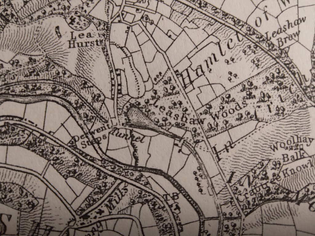
The road layout south of Belper has changed hugely in the past 230 years. Before the Strutts built Milford bridge in about 1790 there were no bridges between Belper bridge and Duffield bridge. Milford was only a hamlet, and its name was originally ‘Muleford’, but with the growth of industry a better all-weather crossing was needed, as well as the construction of the impressive weir. Downstream the Derwent was forded at a point near the current railway station, as shown on Burdett’s map of 1791, and then near the church Duffield bridge is thought to have been built as early as the thirteenth century. In the eighteenth century this crossing was part of the Derby-Chesterfield-Sheffield turnpike route, and so would have been quite busy.

Burdett’s map showing river crossings near Duffield

The Duffield ford must have been more convenient for villagers, especially those going to Makeney or Belper, as well as for drovers moving cattle. In the eighteeenth century and earlier Makeney was a more important settlement than Milford, and it lay on the route of the Portway, which is thought to have crossed the Derwent nearby. The Holly Bush Inn claims to be one of the oldest in the county, and may have served long-distance travellers as well as locals. It may be significant that a holly bush is one of the earliest inn signs, as in the saying ‘A good wine needs no bush’.

The Holly Bush at Makeney

The route from Makeney to Duffield via the ford was once known as Savepenny Lane, since it allowed users to avoid paying the toll which the Strutts charged on their new bridge. However, this route was blocked by the Strutts; deepening the river at that point and blocking the lane on the west bank. The curious result is that today the lane still exists on the east bank, and in fact has recently been confirmed as a BOAT (byway open to all traffic), although it is a cul de sac. An ideal stroll, perhaps, before moving on to a lunchtime pint at the Holly Bush?

The Darley Mystery

St Helen’s, Darley Churchtown

Darley Churchtown is a small part of the large village of Darley Dale. Today it is easily by-passed as it lies off the A6, although it was on the line of the old Matlock-Bakewell turnpike. It has several curiosities, all centred on the church of St Helen’s. The most obvious is right outside the church porch: a huge yew tree, over thirty feet in circumference, and claimed to be anything up to 2,000 years old (see: The Sacred Yew, Chetan and Brueton). Even if this early date is taken with a pinch of salt, it may well have been growing before the Conquest, and would pre-date the existing church (which has a Norman font). It is certainly the largest of all the Derbyshire yews; other notable examples grow at Allestree and Doveridge.

Yew tree in St Helen’s churchyard

If you walk from the churchyard heading south, then take a field path to the right you find yourself walking along a reed-fringed dike, heading for the cricket ground at Darley Bridge. This winding path is still a parish boundary, which suggests it may be the old course of the Derwent, which has since shifted more to the west. This would mean that the church site was virtually an island, with the river running right beside it: even with the Derwent in its present course the church has often been flooded. Yet this is not the only church in this valley built on flood-prone sites: Duffield is another. Could this be an example of the belief that island sites were sacred places? An alternative possibility is that in the early church the river was used for baptism.

Another oddity can be found by walking from St Helen’s in the opposite direction, along the track north towards Rowsley. Just past the school is Abbey House, a substantial Victorian building. The Ordnance Survey map from 1896 marks ‘Remains of Abbey’ at this point, yet according to historians there never was an abbey at Darley Dale. Confusingly, the local abbeys were at Darley, just north of Derby, and at Dale near Ockbrook. So what was the origin of the idea of a Darley Dale abbey?  Curiously, the exact site of Derby’s Darley Abbey has never been identified, though it is presumed to have been on the site of Darley Park. That abbey was linked to St Helen’s Priory in the town, which has the same dedication as is found at Darley Churchtown. Perhaps the safest assumption would be to say that the religious site at Darley appears to be very ancient, quite possibly Saxon, that it could have been a semi-artificial island, and may well pre-date the abbey at Derby.

The lost fords of the Derwent – 1

Railway bridge on Ladygate leading to Old Matlock

River crossings have always been critical points on the road network, and originally these would have been fords, passable for riders in normal conditions, and possibly having stepping stones for those on foot. From medieval times onwards fords on the Derwent were mainly replaced by stone bridges, though their location is still remembered by the place names Bamford, Grindleford, Cromford, Homesford and Milford (from north to south). The original name for Matlock appears to have been Mestesforde (i.e. in the Domesday Book), and many historians have assumed that this ford was near the site of the current bridge. But the nucleus of old Matlock is actually at Starkholmes, not near Crown Island, and so it has been argued that the ford was near the point where Ladygate Lane now crosses the river on a footbridge.

Well below St John’s Chapel

The westward route would have climbed up the hill, past the nineteenth century St John’s Chapel (built over a perpetual spring), and up to Bonsall, near where it linked up with Salters’ Way. The more modern route of Salters’ Lane, leading to Matlock Bridge, developed after this bridge was constructed, although the date of the original bridge is not clear. The access to the bridge on the east side was easy, but because this land (i.e. Hall Leys) flooded regularly (and still does) development may have continued around St Giles for some time.

The site of Homesford from Sanderson’s 1835 map

A few miles downstream, the Homesford Cottage pub (still advertised as selling Kimberley Ales) has become a guest house, and the name Homesford is not found on the OS map. Yet Sanderson’s map from 1835 shows a road from Upper Holloway running down past Lea Hurst (Florence Nightingale’s home) and over Gregory Tunnel on the Cromford Canal. The name ‘Derwent Steps’ by the river suggests a well-established set of stepping stones, with presumably a ford beside for carts and livestock. Today the Derwent can still be crossed here on a footbridge, suggesting that this was an ancient route, but there is no sign of any steps in the currently fast-flowing, turbulent river!.

A walk on the Portway

The Portway as Islington Lane

This walk, which can stand alone or be incorporated into a longer route, gives a taste of one of Derbyshire’s oldest roads, and incorporates many features of historic (or even prehistoric) travel. Starting behind the Miners’ Standard pub above Winster (car parking generally possible opposite) , the track runs north between stone walls. Today the track is labelled as part of the Limestone Way, although Islington Lane, an older name, is a reminder of the miners’ settlement here in the boom days of lead mining. This old road was replaced by the Ashbourne turnpike, now the B5056, which zig zags down the slope to allow carriages an easier incline.

Looking towards Cratcliffe Rocks from the end of Dudwood Lane

After about a mile you cross the Elton road and continue on Dudwood Lane, downhill on what is now a tarmac surface. On the right is the site of the Portaway lead mine, once a substantial producer, which provides clear evidence for the route of the old road. At the bottom of the hill you bypass the cattle grid and start climbing towards Cratcliffe Rocks, with the twin peaks of Robin Hood’s Stride on the left. These rock outcrops must have provided clear landmarks for medieval travellers, and the path runs between them. Evidence has been found at the top of the Rocks of prehistoric habitation, probably to provide shelter for travellers: the summit certainly provides excellent views of the route. Another feature is the medieval hermit’s cave, found in the woods below, which is discussed in a previous blog (Hermits and their Hermitages, 6th August).

Cratcliffe Rocks

Now the track runs beside Robin Hood’s Stride, one of the many Derbyshire features named after this hero. Its striking profile with the rocky pinnacles also gave it the name ‘Mock Beggar’s Hall’. However, the most interesting features of this area are found on the other side of the path, on Harthill Moor, where the stone circle suggests a Neolithic dating. Known as Nine Stone Close, there are actually only four uprights, and there is a suggestion that they may have been re-erected quite recently. Less obvious is an example of cup-and-ring marking on a boulder, a Bronze Age feature not fully understood by archaeologists, but possibly associated with long-distance trackways.

Nine Stone Close

From here the walk can extended on the Limestone Way to Youlgreave, or even to Bakewell via Alport, but the simplest option is to head back towards the Miners’ Standard, where a good lunch and a decent pint can usually be found!