Dark Lanes and Holloways

Longwalls Lane above Blackbrook

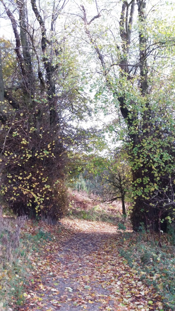
How many ‘Dark Lanes’ can you find on the Ordnance Survey maps of Derbyshire? I know several, for example the one running from Wheatcroft towards Plaistow Green, but there are probably more. In practice these lanes are usually shady holloways, so that the meaning of the name is obvious. But what is the origin of holloways, which are found all over the county, though more commonly on sloping ground?

Over hundreds of years’ use, these tracks, which were most likely no more than packhorse routes, became eroded by the constant wear and tears of hooves and boots. Rain would erode the surface soil until bare rock was reached, as can be seen on Longwalls Lane above. There may well be a relation between the depth of the holloway and the age of the route, though that would be difficult to calculate. But what is clear is that a deep cut lane, lying a yard or more below the surrounding fields, must be several hundred years old.

Holloway near Lea

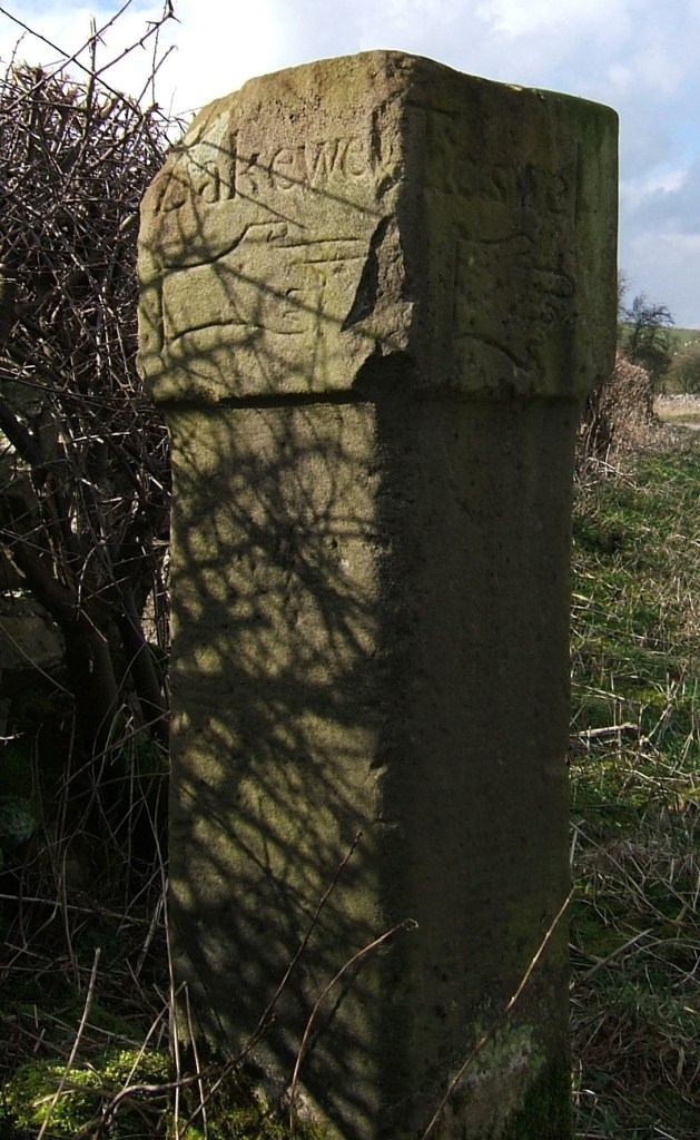
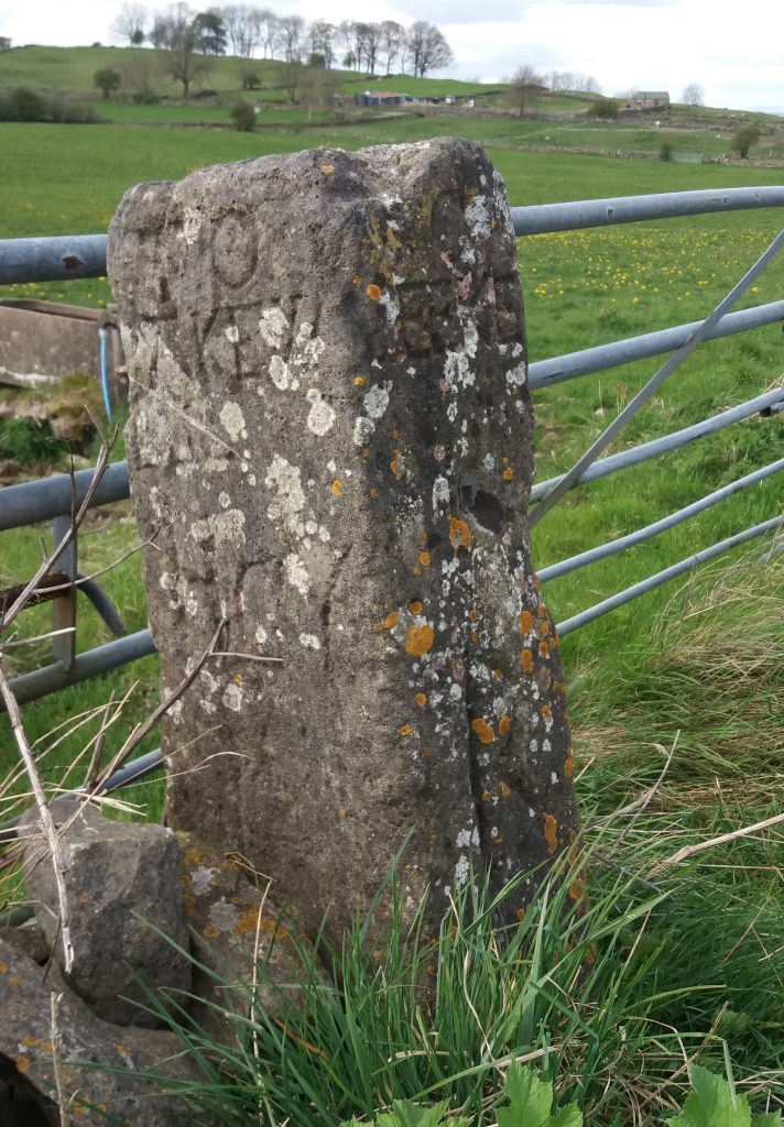
The picture above shows a good example of an ancient holloway, running between Lea and Upper Holloway. Unusually it can be partly dated from an adjacent stile stone (below) of 1780, meaning that the holloway was in use 240 years ago (and probably many more). A steep road in Holloway, leading up to the moor, is called The Hollow, and must have linked to the Lea route as well as giving the village its name.

Dated squeeze stile, Lea

Over time, some holloways became waterlogged, especially in winter, forcing road users to travel alongside. The old path bottom gradually became overgrown and clogged with saplings and brambles, so that the right of way moved parallel but above. Today it seems reasonable to estimate that any holloway is earlier than an enclosure road (most of which date to the early nineteenth century), and may well indicate the local medieval road network.

The Gatekeepers

Tollhouse near Holbrook

The arrival of turnpike roads in the mid-eighteenth century created a new type of job: tollgate keeper. Because the gates had to be manned day and night, accommodation had to be provided for the keepers, although presumably there was little traffic after dark. Many of these tollhouses, such as the one above on the Derby-Chesterfield turnpike, have survived, their original function indicated by their closeness to the road.

The task of collecting tolls was often auctioned off by the turnpike trusts on an annual basis, but the tollhouses and tollgates would belong to the trusts. Providing these added to the considerable cost of developing the turnpike roads, creating debts which, in many cases, would never be repaid.

The joys of gate keeping at night are vividly suggested by Dickens in his early novel ‘The Pickwick Papers’. Pickwick and Wardle are chasing Mr Jingle’s post chaise after midnight, when they reach a tollgate:

After a lapse of five minutes, consumed in incessant knocking and shouting, an old man in his shirt and trousers emerged from the turnpike-house and opened the gate. ‘How long is it since the post-chaise went through here?’ inquired Mr Wardle.

‘How long?’

‘Ah!’

‘Why, I don’t rightly know. It worn’t a long time ago, not it worn’t a short time ago – just between the two perhaps.’

Although toll gates are not marked on Burdett’s map, some are shown on Sanderson’s 1835 map marked as TB (toll bar). In some cases they gave the name to the settlement that grew up around the gate, notably Ambergate, where the tollhouse was near to the confluence of the River Amber with the Derwent. This may also apply to Bargate near Belper and Codnor Gate on the Cromford and Langley Mill turnpike.

Tollhouse on Steep Turnpike in Matlock

Surviving tollhouses can be a concrete reminder of the route of a turnpike road, which often followed a course which seems strange to us today. The example above at the foot of Steep Turnpike, in Matlock, should be no surprise, given the name of the road (note the walled-up doorway beside the road). But the cottage below, In Hopton, is a reminder that the Oakerthorpe to Ashbourne turnpike ran through the villages of Hopton and Carsington: the road beside Carsington Water is modern. Again, note the bricked-up doorway.

Probable tollhouse at junction with the Dene, Hopton

Conquering the stoop

Guide stoop at top of Crowhill Lane near Bakewell

Nearly fifty of these stone pillars survive in Derbyshire, providing vital clues to the medieval road network. ‘Stoop’ is a Scandinavian word for stone, and they have proved suitably durable, many surviving for over three hundred years. They were erected about 1709 to (belatedly) comply with an Act of 1697 which required direction stones to be put up at road junctions in remote moorland areas, where travellers would be likely to get lost. The majority have inscriptions on four sides, and these should indicate the direction of the nearest market towns. The example above shows a hand pointing to ‘Bakewel’, while the other sides indicate the directions of Tideswell, Buxton and Winster. It is notable that the stone now stands at a T-junction; the fourth route was closed with the opening of the turnpike road on what is now the nearby A6.

Guidestoop above Winster on road to Grangemill

This illustrates one of the values of these stoops: they show the routes that were in use pre-turnpike and pre-maps. The Winster stoop, above, provides another example. It is thought that originally it stood at the end of Bonsall Lane, and indicates Wirksworth, Bonsall and Bakewell. The fourth town marked, however, is Leek, over 15 miles away via Pikehall, but clearly a significant destination at that time. As with some other guide stoops, this one has been used as a gatepost, since most stoops would have become redundant with the arrival of better signposted turnpikes later in the eighteenth century. Nearby, at Shothouse Spring, another stoop (on private land) is no longer on any road or path, although it was clearly erected at a one-time crossroads.

Guidestoop at Alport Height

The Alport stone (showing Derby, Wirksworth and Ashbourne) is another example of a stoop at an apparently remote junction, but clearly thought worth marking in 1709. In fact its position on the Portway suggests that it would have been a more important route at that time. To properly envisage early eighteenth century travel we need to remove most of the dry stone walls and grassy pasture, and go back to a landscape of open scrubby moorland, crossed by the occasional track. In this setting it is easier to imagine the reassurance that the guidestoop would have given the uncertain traveller.

(For a detailed guide to all surviving stoops see ‘The Guide Stoops of Derbyshire’ by Howard Smith)

A walk around Horsley Castle

This 4-5 mile walk includes a medieval castle and a section of the Portway, plus another ancient holloway. Parking is available at various points, but perhaps the simplest is at Coxbench, on the road parallel to the A38 embankment that leads to the kennels, marked MP on the map above. Follow the path up by the kennels, and then take the right-hand path up into the wood. The area to the west has been extensively quarried and the path is effectively following the edge of these quarries. The path then changes direction, turning east, and the ruins of Horsley Castle can be seen on the right.

Like several other Derbyshire castles (Duffield, Pilsbury) little remains of this one, beyond a clump of rough masonry on a mound. It is easier to see the layout in winter, before the trees are in leaf. Little is known of the history of the castle, which is dated to the twelfth century. Clearly most of the stone was robbed when it went into decline. It is nearly a mile from Horsley village, and is presumably sited here to take advantage of the high ground and possibly the proximity of the Portway, which is the route of the footpath, offering good views to the north and west. On the Historic England website it is said that the castle ‘overlooks the strategic Derwent Valley’: clearly impossible given the high ground between here and Duffield!

The castle ruins

From here continue eastwards to Sandy Lane, and then follow this uphill to the settlement of Brackley Gate. The route turns sharp right here, downhill towards Horsley Carr, but note that if you continue on the top road to Quarry Road you will cross the line of Ryknild Street, one of the most important Roman roads in Derbyshire, although now invisible here. The track descends through dense woodland, and when this opens up on the right, take the path that leads you to a tunnel under the A38 road. You now cross, in quick succession, the road to Little Eaton, the Bottle Brook, and the course of the old railway, before turning left on the Alfreton Road for a few hundred yards. Just past the Bell and Harp pub take the road to the right which runs up past houses before climbing more sharply through the wood. This track, in part a holloway, may have been a church path to Duffield church (but also to Duffield bridge).

After half a mile turn right onto the field path running north, and then bear right beyond Daypark, where several tracks lead down to the Holbrook road, here named as Port Way – the only surviving ‘official’ naming of this old route. From here it is less than a mile downhill to Coxbench, where you turn right and then left under the A38 again, back to the starting point.

Church path to Horsley from the Holbrook Portway

The way through the woods

In Bow Wood near Lea Bridge

Over time, many routes have been abandoned, due to changes in settlement patterns, agriculture or the construction of better, easier roads. The medieval route through Bow Wood from Castletop farm to Lea Bridge, shown above, is now a rough track, but its previous status is revealed by the stone gateposts, indicating a width suitable for carts or carriages.

The image of the lost road has always had romantic appeal, an appeal explored by Kipling in his poem ‘The way through the woods’:

They shut the road through the woods

Seventy years ago.

Weather and rain have undone it again,

And now you would never know

There was once a road through the woods

Before they planted the trees.

It is underneath the coppice and heath

And the thin anenomes.

Only the keeper sees

That, where the ring-dove broods,

And the badgers roll at ease,

There was once a road through the woods.

Yet, if you enter the woods,

On a summer evening late,

When the night-air pools on the trout-ringed pools

Where the otter whistles his mate,

(They fear not men in the woods,

Because they see so few)

You will hear the beat of a horse’s feet,

And the swish of a skirt in the dew,

Steadily cantering through

The misty solitudes,

As though they perfectly knew

The old lost road through the woods …

But there is no road through the woods.

The pre-turnpike road from Rowsley to Bakewell

Today some of the ‘lost roads’ survive as footpaths with public rights of way, kept open by dog walkers and hikers. However, especially in high summer when the vegetation reaches shoulder height, and encroaches on the path from both sides, it is easy to see how fast an unsurfaced route can disappear. Perhaps the surprising thing is the number of roads that have survived over hundreds or thousands of years, rather than those that have disappeared.

The story of the stones

Stone near Wirksworth-Brassington road about one mile west of Wirksworth

It seems likely that single standing stones like the one above, which is over two metres high, have been used as route markers for possibly thousands of years. Stone is readily quarried in north Derbyshire, and once erected they are extremely durable, although some may have been broken up when the commons were enclosed. But in an open, moorland landscape they would have clearly stated ‘here is the route’ and would have been visible a mile away.

No-one knows how many such stones survive today, and not all are marked on the OS map, unlike the stone illustrated. They can be confused with gateposts, but these are generally shorter and have holes bored in them to attach hinges. Some have been worked so that they have been roughly squared, although they have no inscription, as with the stone below, which can be found at SK 299521, just off the public footpath but clearly visible from it. The location is in a direct line from the top of Alport Height to the alignment of Prathall Lane, leading into Gorseybank, southeast of Wirksworth, which might have been the route of the Portway in early medieval times.

Looking north to Middleton and Cromford moors

A third stone near Wirksworth can be seen opposite the Malt Shovel Inn, near the crossroads of the Alfreton-Ashbourne turnpike with the route down to Belper from Bolehill, although it must be much older than these. It is marked on an early nineteenth century map as ‘menhir’ and may well indicate a very early route of the Portway, avoiding the steep descent into the town by circling it on the east and north sides. As with the other stones, this is on private land, but is clearly visible from the road.

In common with many other prehistoric and historic sites, we can never know the full story behind these enigmatic stones, but this basic supposition – that we are looking at ancient route markers – is supported by the use of similar stone markers (but with lettering) for guide stoops in the early eighteenth century and then the introduction of regular milestones on the turnpike roads.

Stone near the Malt Shovel pub

Using maps to research old roads

Maps are an obvious choice in researching the road network of the past, but they have several limitations. There are no accurate maps of Derbyshire’s roads before the mid-eighteenth century, when Peter Burdett published his inch-to-a-mile map of the county in 1767 (see section above). We can assume that the road network presented by Burdett was essentially the same system that had operated since medieval times, but many minor roads and paths were not included.

Burdett marks the new turnpike roads with solid lines, and shows the milestones, while broken lines are reserved for less important roads. The map reveals many changes over the past 250 years: East Moor covered a much larger area, for example, while the centre of Matlock was focused on St Giles, rather than Crown Square as today. Some of the place names are unreliable, so Whatstandwell is written Hotstanddell – perhaps the surveyor misheard a local accent!

Burdett’s map was revised in 1791 to include new industrial sites such as coal mines and the Cromford canal, but the next large-scale map was Sanderson’s map of 1835, ‘Twenty miles around Mansfield’, which covers the eastern part of Derbyshire and shows field boundaries and many road names.

This section of the map, covering a similar area around Crich, shows the growth of enclosures in the early nineteenth century over East Moor, as well as displaying the road network in more detail. At a scale of two and a quarter inches to the mile it was the largest scale map so far produced, and so is more valuable in some areas than the Ordnance Survey one inch to the mile map of Derbyshire, first produced in 1840.

Clearly all such early maps have their drawbacks and omissions, but for road historians they provide an invaluable reference source, full of clues to the landscape of the past.

Hermits and their hermitages

Sneinton Hermitage

Hermits are generally imagined to be solitary recluses, who adopted an isolated life to focus on spiritual matters. Yet little is known about the lives of individual hermits, which are first mentioned in Britain about 700 CE. Most surviving ‘hermitages’ are natural or man-made caves, and a remarkable feature of our region is the four hermitages on the route of the Portway; two in Nottingham and two in Derbyshire. This distribution suggests that the hermits who lived there helped travellers on the road, either with practical information or possibly with their religious issues. Hermitages were sometimes linked to a monastery or abbey, and in our case one was connected with Lenton Abbey west of Nottingham, while Dale Hermitage was a forerunner to Dale Abbey, built close by.

Nineteenth-century painting of ‘druidical remains’, Nottingham by W. Bradbury

Sneinton Hermitage, a mile east of the centre of Nottingham, is cut into the sandstone rock on which much of the town was built. It is now protected by steel railings, and was apparently larger before the site was developed by railway construction. Travellers disembarking from boats on the River Trent would have approached the town this way.

The second hermitage, illustrated in the painting but wrongly described as ‘druidical remains’, is now on private ground behind a modern block of flats on Castle Boulevard. Hermitage Walk, a street in the Park above, used to give access to the caves, which, judging by the painting, were given a parkland setting at some point. The most unusual feature of this group of caves is a rock-cut chapel known as St Mary de la Roche, which may have been the work of friars and could have been a pilgrimage centre before the site was acquired by the monks of Lenton Abbey in the thirteenth century.

Dale Hermitage

The third hermitage, and the most accessible, is in an idyllic woodland setting near Dale in southeast Derbyshire. At this point the Portway descends a steep slope, and a hermit could have given travellers practical guidance. The photo shows a series of holes cut in the rock face above the door, which presumably allowed a wooden extension to be built in front of the cliff face. According to legend, a Derby baker was told in a dream to come and live in Depedale, and he was the predecessor to the monks who established the Abbey, now almost entirely demolished, in about 1200 CE.

Cratcliffe crucifix

Cratcliffe Hermitage can be found by forking off the main path up to Robin Hood’s Stride on Harthill Moor. It’s a bit of a scramble to reach it, but the position is spectacular, looking back over the Portway towards Winster. The rock opening is flanked by two old yew trees, presumably planted in the nineteenth century, and railings protect the remarkable carved crucifix on the wall inside. Unusually, there is a record in the accounts of Haddon Hall (only two miles away) of the hermit selling rabbits to their kitchen in 1550, so apparently he had survived the Dissolution of a few years earlier.

Taken together, these four sites provide a possibly unique insight into the reality of medieval travel. Among the various types of wayfarers would have been pilgrims, heading for shrines in Dale or Lenton Abbeys, who may have supported the hermits in return for their prayers for a successful journey. Other travellers would have been glad of information about the next stage of the journey, and possibly suggestions about where to find food and shelter for the night.

Cromford Bridge

Upstream view of bridge

It is easy to forget how crucial bridges were to the medieval traveller, who could otherwise be delayed at a ford for days, waiting for the river to be passable. Many bridges, including Cromford, were probably originally timber structures with stone piers.

The name ‘Cromford’ means a ford on a (river) bend, and it seems likely that the ford was roughly in the same place as the bridge, just below the point where the Derwent curves out of Matlock Bath. This must have been a vital crossing point, linking the route descending Cromford Hill from Wirksworth and beyond with the road to Starkholmes and old Matlock, plus the older route up along Hearthstone Lane, and the road to Lea Bridge going through Bow Wood.

Dating bridges is always difficult since most have been widened and frequently repaired. In this case it can be seen that the arches are pointed on the upstream side, but more rounded on the downstream, suggesting a substantial rebuild from an original packhorse width. It is generally thought to be fifteenth century, but may be older.

What makes this bridge so special are the ruins of a bridge chapel on the west bank – not to be confused with the later fishing house. Bridge chapels were built to allow travellers the chance to pray for a safe journey and perhaps leave an offering for the upkeep of the bridge. Only a handful survive in Britain, and this example may have been built at the same time as the bridge. It became ruined after the Reformation, but was excavated and repaired by the Derbyshire Archaeological Society in 1951.

Next door to the chapel ruins is the more recent fishing lodge, which has very recently been given a new stone roof. Over the door is the inscription ‘Piscatoribus sacrum’ meaning sacred to fishermen. It may well have been built by the Arkwrights, possibly for their water bailiff. Their grand house, Willersley Castle, dominates the view on the opposite side.

The fishing lodge

Another, easily overlooked feature of this busy bridge is a stone inscription ‘THE LEAP OF MR B H MARE JUNE 1697’ on the southern parapet, marking the spot where a Benjamin Hayward leapt on horseback from the bridge into the river. Presumably the river was in full flow at the time as apparently both horse and rider survived.

Mare’s leap

The bridge is near the terminus wharf of the Cromford canal, opened in 1794. But it was also the rather unlikely starting point of the Cromford Bridge and Langley Mill turnpike road, which ran from there along the east bank of the river towards Lea Bridge, and then on to Holloway, Crich and Bullbridge. This road seems to have opened in the early nineteenth century, and would have provided a faster link with Nottingham and district, replacing the old hilly route past Castletop and through Bow Wood. This is the road which was badly affected by flooding in late 2019 and has been closed ever since.